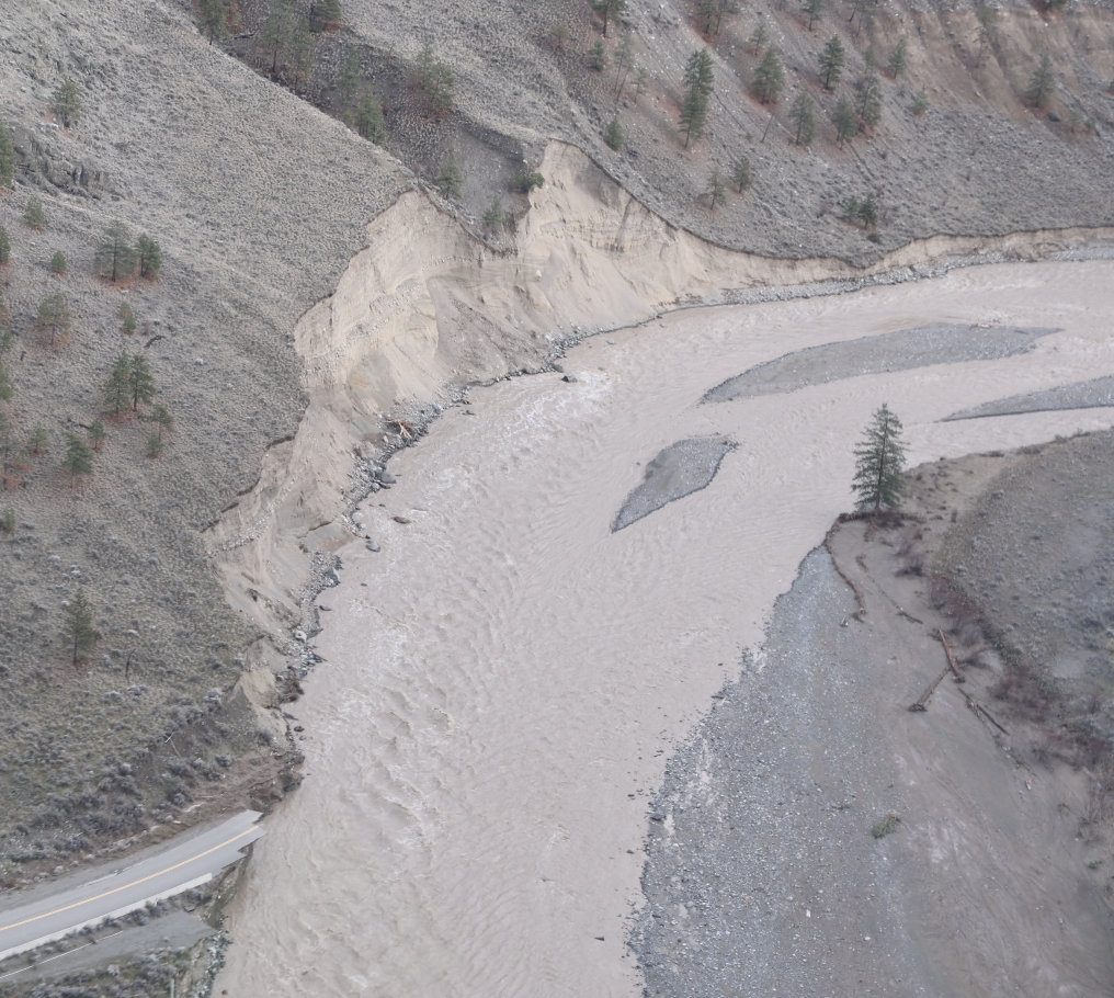
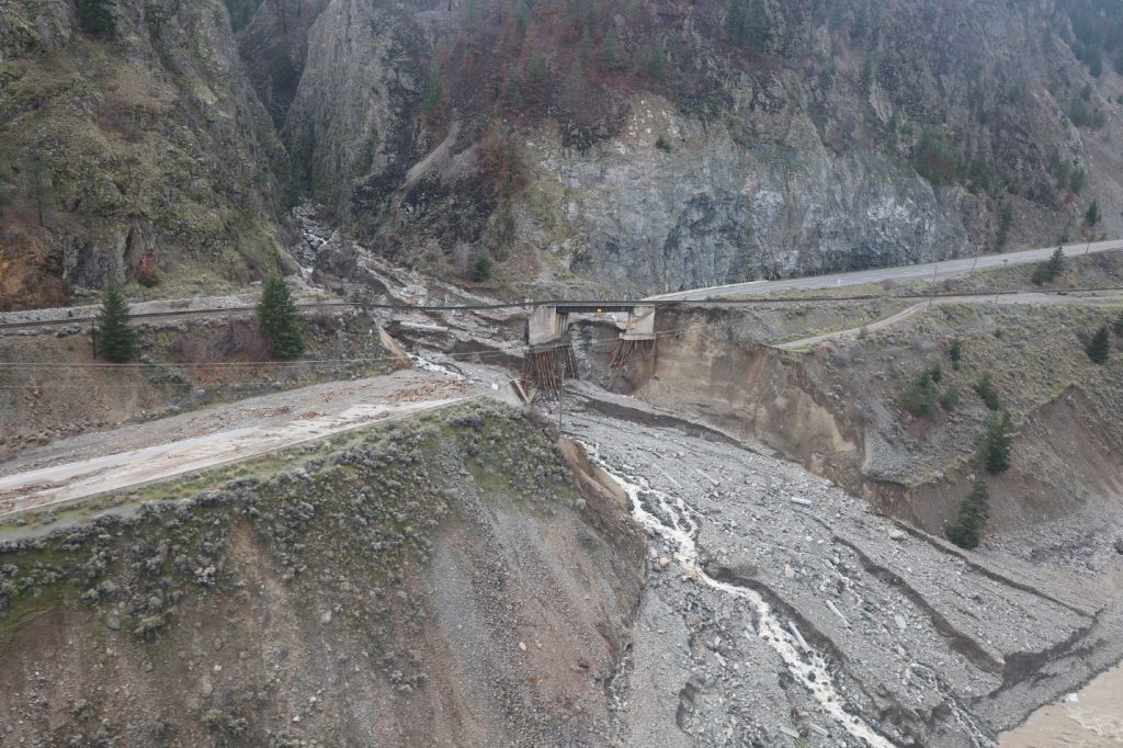
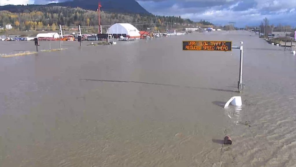
The south coast of BC is often referred to as the “Wet Coast” – a lighthearted nod to the high levels of rain that fall here annually. However, during the BC flooding of November 2021, a series of atmospheric river events dropped an unprecedented volume of water across the southwestern area of the province, resulting in a widespread flood and catastrophic damage. Major bridges were destroyed, large sections of highways sunk into rivers. Every major route connecting the Lower Mainland to the rest of Canada was cut-off, stranding tens of thousands of people, damaging homes, impacting huge volumes of livestock, and halting the movement of citizens and billions of dollars in goods and services. It was intense and unprecedented. This is the story of our role during the incredible event, our work to re-establish connections in and out of the province and our plans to rebuild BC highways better.
Our Response During the Crisis
As the ministry responsible for managing BCs provincial highway system, we’re no stranger to emergencies – our staff regularly respond to weather and traffic events on BC highways during flood and fire seasons. But the scale of this event and its devastating impacts were far beyond what our ministry had ever experienced. Initially, the atmospheric river event of November 14-15 seemed like a typical November “Pineapple Express”. However, it quickly became clear that rainfall levels were higher than expected. As water levels rose, ministry staff jumped into action closing highways and communicating closures and impacts out to the travelling public.
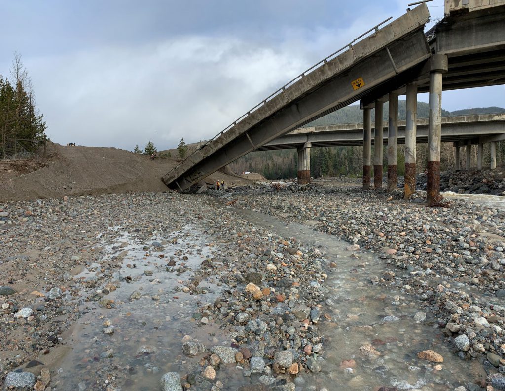
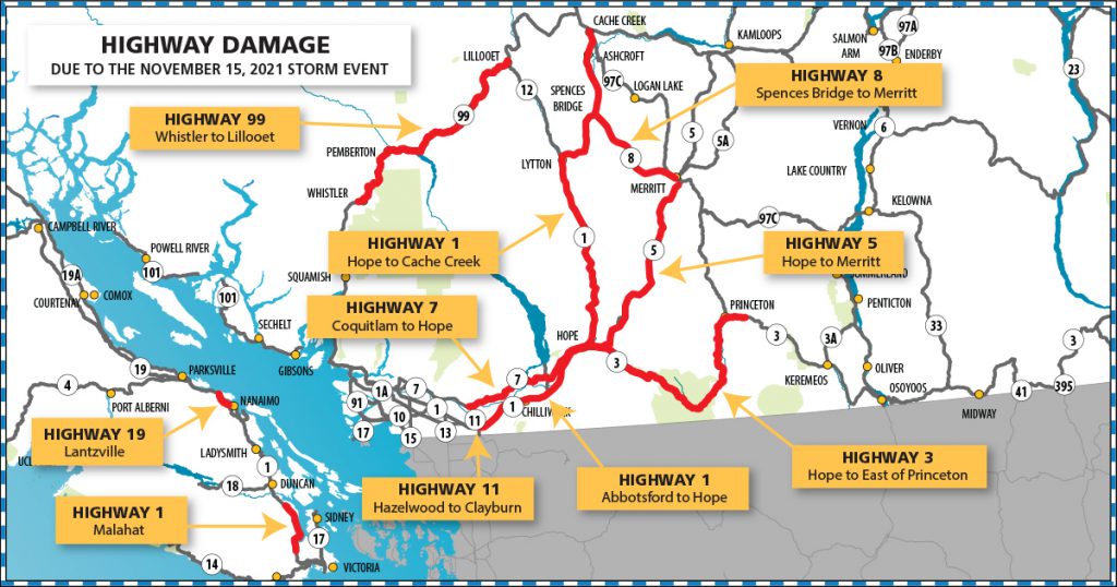
Once the weather system had passed, the ministry was able to deploy engineering, geotechnical and operational staff into the field to perform corridor assessments and bridge inspections. All told, more than 300 sites on Highways 1, 3, 5, 7, 8, 11, 19 and 99 were impacted due to water damage, ranging from minor to complete loss of infrastructure.
The ministry, along with provincial emergency management, local municipal governments and the federal government, quickly pulled together with a common goal: to get highways re-opened, people home and supply chains restored during the BC flooding. Emergency Operations Centres were activated and plans were developed to mobilize resources to establish emergency reconnection. Highway 3 was prioritized for immediate repair, to provide a corridor for essential goods and services while crews worked around the clock to re-establish connections on the badly damaged Coquihalla Highway; however, the windy, two-lane road was considerably slower going than the Coquihalla and winter conditions meant additional delays.
A provincial state of emergency was declared on Nov. 17, 2021 (lasting until January 18, 2022). Early on, that meant fuel restrictions were put in place across southwest BC, and routes were limited to essential travel only, to ensure that life-saving services and essential supplies could be delivered. To ensure the public was kept informed of the rapidly changing situation, our own communications team here at TranBC, was active throughout the emergency, communicating new developments and sharing updates as required.
We created teams for each impacted corridor and included ministry and maintenance contractor staff, Indigenous environmental and archeological monitors, consulting engineers and construction firms. They worked in synchronicity, 24/7, designing, constructing and monitoring progress in real time.
Boundaries between jurisdictions, contracts, and communities relaxed in favour of collaboration, speed, and safety. The priority was restoring safe emergency vehicle access and emergency supply chains, and access for public health and other support services. Teams coordinated safe exits for hundreds of vehicles stuck between multiple mudslides. They worked with the agriculture sector to ensure safe passage for livestock at risk of starvation and collaborated closely with emergency responders to provide emergency access for communities that were without supplies, clean water, and power, or to bring in supplies where road access was not possible.
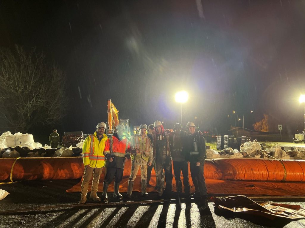
Other scenarios required a different level of response. To protect Highway 1 around Abbotsford, from further damage from a breach of the Nooksak River, a temporary “tiger dam” was installed. This was an unprecedented collaboration by the Canadian Forces, Abbotsford emergency responders, local First Nations and the ministry. It took place with over 70 volunteers working throughout the night to hold back the threat of more flooding.
Reconnecting Our Roads
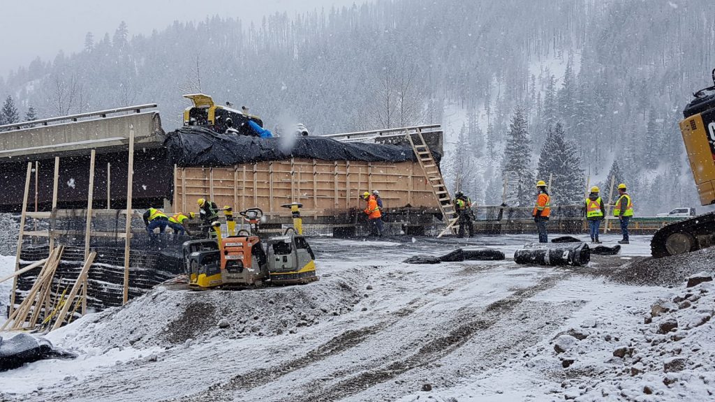
Work restoring damaged highways took place at more than 300 sites and was performed by thousands of people and hundreds of pieces of heavy equipment. Challenges were numerous, including a second (and third!) atmospheric river event, winter storms (with temperatures below -20 Celsius and higher than average snowfalls) as well as health precautions due to the COVID-19 Omicron variant.
Each obstacle was faced with determination and commitment to continue the work. These monumental efforts to safely reopen routes and reconnect BC’s supply chain were realized in under two months, with Highway 5 re-opened to commercial vehicle traffic on Dec. 20, 2021 (just 35 days after the flood event) and then opened to all traffic on January 19, 2022. Other impacted locations took longer to reconnect, with Highway 1 opening on January 24, 2022, after the installation of a temporary acrow bridge at Jackass Mountain. Highway 8 remains in active recovery, with work continuing seven days a week to re-establish connection on the corridor.
British Columbians (and the rest of the world) followed this incredible progress and celebrated our collective success in reconnecting our roads and communities once more. We want to thank everyone for their support and understanding during this extremely challenging time. It was truly appreciated.
Our Plan for Building Back Better
The people who build and maintain roads in British Columbia have a reputation second to none, and their response to this disaster was remarkable. Working day and night, this team of dedicated folks completed temporary repairs that allowed many areas to reopen. However, the damage is extensive and it will take years to fully recover. Now that we’ve turned the page from emergency response, we are focused squarely on building back better — making sure our highways network is strong, resilient, and reliable for the new climate reality we’re in.
Through the B.C. Highway Reinstatement Program, we’re undertaking the long-term reinstatement of critical transportation infrastructure damaged by extreme weather events of November 2021. We will be engaging with communities, local governments, Indigenous communities, and stakeholders to discuss the potential long-term transportation solutions at each project site.
Since 2015, the ministry has had a policy that all highway infrastructure designs must consider future climatic events. Our design engineers and consultants must consider what can be done to make our roads and bridges more resilient, so they remain reliable and open, over the entire design life of our infrastructure. This policy applies to new infrastructure, rehabilitation work on existing infrastructure and repairs to damaged infrastructure, such as what occurred on highways 1, 5 and 8.
Examples include:
- pile driving bridge footings
- upsizing culverts
- bridging areas of concern where culverts are no longer suitable
- redesign of drainage channels for future flow
- better armouring of slopes
Recognizing that the science of adapting infrastructure to climate change is relatively new and still evolving, we are constantly learning from each event that occurs, and the November event has given us new data to consider as we review and enhance our policy to be even more resilient to future climate events. We have partnered with groups like Engineers and Geoscientists BC to create guidelines to assist designers, and the Pacific Climate Impacts Consortium at the University of Victoria, in providing future climate modelling for designers to use as they consider future climate events. All of this work will help BC’s highway designers create infrastructure that will be more resilient to future climate events.
What Does this Mean for You?
The exceptional damage from the flooding and our efforts to rebuild better mean that travellers on BC highways can expect improvements but not without significant delays over the next few construction seasons.
We’re working hard to coordinate these works across the province to help minimize those delays; however, travellers are encouraged to plan ahead, give themselves plenty of extra travel time and be prepared to stop while we repair our roads. DriveBC.ca, our traveller information system, is your best bet for information about any event on BC highways that are impacting travel.
Our construction is not just limited to flood recovery — it includes all the other projects we’re working on across the province, like our Highway 1 Kamloops to Alberta Four Laning Program, which continues at multiple locations on the corridor. In order to keep travellers informed of anticipated delays between Vancouver and the Alberta border, we’ve updated our Trans-Canada Highway Four-Laning advisory site to include estimated travel times for the Coquihalla Highway as well. If you are planning on travelling between Hope and the Alberta border this summer – make this advisory site your first stop and build our estimates into your travel time.
The road to recovery has begun and we are looking forward to making BC’s transportation infrastructure the best it can be. We appreciate your patience as we continue to work toward better highways for all your future travels.
If you found this article interesting, you might also like these stories
>>> Meet BC SIMS – Our Seismic Infrastructure Monitoring System
>>> DriveBC Agents – A 24/7 Channel to BC Highway Information
>>> How We Are Fighting Wildfire Impacts at Elephant Hill
>>> What is Freshet? Hint: It’s NOT an Air Freshener
>>> Are These the Most Amazing Emergency Vehicles in BC?
Hi, great article. can I get the list of stakeholders of the project, so that I can analyze them as well
Hi there, Deep
Here’s a link to more information on works underway and different groups involved. https://engage.gov.bc.ca/bcfloodstrategy/
Hope this is helpful!
Please investigate the practicality of boring tunnels instead of running highways along stretches where washouts are a risk. Tunnels don’t experience landslides and are safe in earthquakes and floods. Moving forward, it isn’t very practical to continue to run our highways along embankments that are to wash out any constructions the next time an atmospheric river hits.
Hi Kolten – thanks for connecting with us here. Unfortunately, not all rock and geography in BC is suitable for tunneling. When we plan projects, analyzing options is a critical part of our process. We evaluate the pros of those options against their technical difficulty and cost to build and maintain. If a design includes tunnels while achieving the objectives within the available budget, they might become part of the final solution. We are currently reviewing our infrastructure in recently impacted areas, as well as the surrounding areas they are located in, to get a better sense of how they might be impacted by the effects of climate change and what ways we can help mitigate those impacts. Thanks again for connecting with us to share your suggestion.
Could you please provide updates on restoration of the various trails and facilities for walking, cycling, and off highway vehicles that were affected?
Is there a plan to shift more freight to rail in order to reduce ghg emissions from trucking and improve safety?
Thanks!
Hi there Desmond – thanks for your question. We have shared it with our staff in the area and will let you know what we hear back.
Hi again Desmond – do you have a specific area or network of trails you are interested in learning more about? In regards to your question about trucking – the ministry is currently developing a Goods Movement Strategy, in an effort to provide leadership and coordination among transportation industries and achieve greater coordination between roads, railways and ports. This strategy will also support provincial climate change goals to reduce GHG emissions. Here’s a link to more info: https://strongerbc.gov.bc.ca/plan/
Well Written Article.
Many Lessons were Learned and Will be used in The Present as well as The Future.
Some Things can’t be Learned in A Laboratory or Class Room.
Keep up The Good Work.
It really bothers me to think the government of the day that thought they where doing something good when they removed the toll and infrastructure on the couqihalli highway I spent a good many years employed on the construction of it and had come to realize that it costs a lot of money to build and maintain our highway system in our province in the mountainous terrain and what a great way to share the cost with the rest of the continent and I think think that when politicians make stupid decisions like that they should be held responsible for decisions like that compare a normal passenger vehicle could pass through the toll both at a cost of $10.00 and travel our beautiful country on a 4 lane hi way was really cheap in place of saving 100kmm plus travelling our existing number one hiway and I think the system should be replaced or instated as soon as possible let’s let the rest of the North America pay for our highway systems. Thank you 😊
Glen, thanks for sharing your opinion about tolls on BC highways, including the Coquihalla.