
The Coquihalla is one of the most popular highway mountain passes in BC. You’ve probably driven it a few times, whether as a commuter or a BC traveller, or TONS of times as a commercial driver. But how well do you know this stretch of highway?
GENERAL STATS
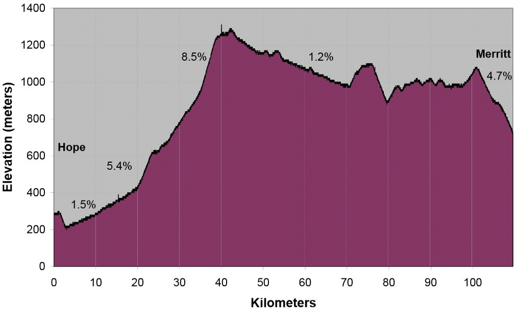
- The Coq starts near sea level at Hope and then gains over a kilometre in elevation in less than 50km distance.
- Highest elevations:
- Coquihalla summit: 1,244 m
- Surrey Lake summit: 1,444 m
- The length of the Coquihalla, per construction phase:
- Phase 1 from Hope to Merritt: 110km
- Phase 2 from Merritt to Kamloops: 87km
- Phase 3 from Merritt to Kelowna: 127km
- Travel time savings:
- vs. the old Highway 3 Route – from Kelowna area you save approximately 70km of travel or/and an 1h30mins
- vs the old Fraser Canyon Route (Trans Canada) – from Kamloops via the TCH you save approximately 70km and 1h 10mins
- Coquihalla Opening:
- Phase 1 opened in May 1986 (Hope to Merritt)
- Phase 2 was completed on Sept 4, 1987 (Merritt to Kamloops)
- Phase 3 was completed on Oct 1, 1990 (The Coquihalla Connector from Merritt to West Kelowna )
- Named the Coquihalla because it generally follows the Coquihalla River and uses the Coquihalla Pass
- The small signs in the shape of old steam locomotives, with Shakespearean names, along the highway commemorate approximate locations of the Kettle Valley Railway
WINTER
- The Coquihalla averages 1,350mm of precipitation of which 1,150mm falls as snow
- The annual average peak snowpack (depth of snow on the ground) is 235cm at the summit
- Winter maintenance:
- Average amount of winter abrasive used yearly: 40,000 m3
- Average amount of anti-icing liquid used yearly: 3 million litres
- During storm events, in addition to other equipment and snow plows VSA maintenance uses 3 tow plows which can clear two lanes at a time. Two of these plows spend 100% of their time on the Coquihalla from Hope to Kamloops.
- There are many “tools” engineered into the design of the Coquihalla Highway to reduce the likelihood of avalanches affecting the route, which is why the Coquihalla sees less frequent closures for avalanche hazard and avalanche control than many other mountain passes in the province. These defenses include:
- Road alignment designed to use Boston Bar creek as a natural catchment area
- Ten earth structures (stopping dams and mounds) which you probably wouldn’t notice because they are now covered with vegetation.
- There is also one concrete stopping wall and one snow shed
- Since the winter of 1990/1991, in regards to avalanche closures…
- Less than one closure per year due to avalanche hazard, specifically .96 per year over 25 years
- 13 out of the last 25 years had no closures due to avalanche hazard
- Of all the 24 avalanche closures, 11 were under 2 hours
- The top 3 reasons for closures on the Coquihalla (in order of time spent) are
- Vehicle incidents (such as stalls, vehicle fires, trucks spinning out, etc.)
- Collisions (when a vehicle crashes into something) and the subsequent investigation and clean up
- High avalanche hazards
TRAFFIC
- Highest daily volume for traffic:
- BC day long weekend (29,114 on August 1, 2014)
- Percent of that truck traffic: 22%
- Annual Average Daily Traffic (AADT): 10,569
- 3.3 million Annual VKT/km (VKT/km represents the annual vehicle kilometres travelled, divided by the length of the roadway)
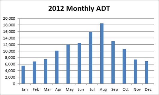
- Busiest traffic month: August (based on 2012 stats)
- The Coquihalla has twice or more the volume of traffic compared to any other highway that crosses a mountain path in BC (based on 2012 stats)
- From 2004 to 2010
- Truck traffic increased 6%
- Personal vehicle traffic increased 5%
We hope that answered some questions or piqued your curiosity around the Coq. It’s an interesting stretch of highway that comes with its unique challenges but our district staff and maintenance contractors will continue to monitor the Coquihalla and keep you moving as efficiently and as safely as possible.
Did you find this content interesting? Check out these related links:
How often is the Coquihala closed for all reasons (avalanche, blizzard, vehicle stalls, accidents etc)?
On average how many days per year is the road closed for all reasons and for what duration?
Hi Richard.
Thanks for connecting with us here. We have some some data in an excel file that we can send you about this. What would be the best email to send that to?
So…what’s the grade for north of the snow shed?
The grade on the “Snow Shed Hill” between the Great Bear Snow Shed and Zopkios Brake Check is 8%. Safe travels!
In May 2022, I drove the Coquihalla to/from my way to Edmonton for the first time. Stunning scenery and an engineering marvel. It was a little nerve wracking in my little Toyota Matrix but I am glad I did it. I will be driving that route every other month during the “non-snow tire” months.
I am now glued to the TV show “Highway Thru Hell” and have a much better understanding of the miss-adventures of travel along the Coquihalla and how easily accidents can happen.
At the top of this website, you provided good general statistical information. Thank you!
Hello Anne and thank you for your message. Despite recent challenges on the lower portion of the highway, the Coquihalla does indeed remain a marvel of engineering. Now that you are a Highway thru Hell fan – you might be interested in some of our Highway Thru Hell content:
https://www.tranbc.ca/2012/11/01/5-things-to-learn-from-watching-highway-thru-hell/
https://www.tranbc.ca/2013/01/09/highway-thru-hell-the-complete-tranbc-interview-series/
Safe travels!
why is a portion of the highway called “the smasher?”
Hello Randall – thanks for connecting with us here. We can’t say for sure however, we can venture a guess that this term was coined by commercial truck operators who experienced one or more vehicle incidents at the summit/tunnel location.
How long will it take to drive the Coq at an easy sight seeing pace? Is there a highwqy that runs the complete length of Canada?
Hello John,
Thanks for your questions. The travel time between Hope to Kamloops is approximately 2 hours. The Trans-Canada Highway is your best bet for longest continuous stretch of road across Canada. Hope that this information is helpful. Safe travels.
What are the concrete “bunkers” visible along the #5 highway between Hope and Merritt?
Hello Greg. Thanks for your comment. There are remnants of a few structures which might be visible along this stretch: Avalanche bunkers – where avalanche techs might have set up and used older military style explosives to trigger avalanches in the area; avalanche benches – which are installed to stop the flow of snow onto the highway; or there is also the remnants of an old telecommunications gondola, which carried service workers up to the peak of Dog Mountain “back in the day”. Without knowing exactly the location you are referring to exactly, we would guess that one of these is what you’ve seen. We hope that this is helpful. Safe travels.
Ran it opening day may long weekend in 86 no signs for brake check at top of smasher it was quite the ride coming over the top at 100 km apparently motor ways put 6 in the runaway lanes that week so I was told
Thanks for sharing, Dan!
Can you tell me the amount of fatalities on this pass since it opened?
Hi there Marijke,
Thanks for connecting with us here. Unfortunately, we don’t have this information. ICBC tracks these statistics here: https://www.icbc.com/about-icbc/newsroom/Pages/Statistics.aspx
It looks like the statistics presented on the page don’t go back to 1986, when it originally opened, but you might be able to reach out to ICBC for more information. We hope that this information is helpful. Safe travels.
What are the round cement bunker like structures along the highway??
Hi there Cass – thanks for your question. There is an installation of concrete blocks along the highway placed there to block avalanche flow. Without knowing exactly the location you are referring to exactly, we would guess that is what you’ve seen. Safe travels.
The round concrete blocks your referring too are at the widened breaks in the highway barriers where the Military used to pull off and set up and shoot up into the snow packed mountains for avalanche control.
Now they just drop bombs from the helicopters in the exact location of the avalanche hazard.
Good info, glad I don’t have to drive it this winter (no tourists or school trips!)
In the line “The Coquihalla averages 1,350mm of precipitation of which 1,150mm falls as snow,” below the graph, you might want to change the units of measure. It should be cm, not mm. 1,150mm is a measly 1 meter and 15 cm 🙂
Cheers
Peter
Hi there Peter,
Thanks for your message. We reached out to our weather and avalanche group for clarification and they let us know that the issue is the difference between measurement of precipitation and snowfall. Precip is the water equivalent of the accumulated snowfall plus the amount of any rainfall, measured in mm. So when we said 1150 mm falls as snow, then that’s the water equivalent of the snow. Rule of thumb conversion from water equivalent to snowfall is about 10:1, so that would have been approximately 1150 cm of snow, but we were talking precipitation, not snow depth. Hope that this information is helpful.
Time to think about a toll road again
Thanks for your comment anonymous. At this time, we are not considering making the Coquihalla a tolled route.
Why we already paid for it plus some. Why pay for it again?
Do you guys know the annual snowfall for Thar peak? I know you said 235cm snowpack but I doesn’t specify how much snow actually falls annually.
Hi Scott,
Our local avalanche staff has let us know that while we don’t have a weather station there, we do have the following info to share:
1. There isn’t actually a single number to answer the question, because freezing levels very so much in the mountains around the Coquihalla.
2. At road level (1220m), we receive annually an average of about 1150cm of snowfall (235cm average snowpack). This year we were way below average, receiving only 674cm of snowfall.
3. At ridgetop (1660m) our average is 1850cm of snowfall, and this year we only received 1269cm.
Hope that this helps!
Does an agency record statistics for the number of highway road closures per year?
Hi there – this information is availabel via the DataBC DriveBC catalogue here:https://catalogue.data.gov.bc.ca/dataset/historical-drivebc-events
Depending on what you want to see (all closures in BC? Specific highway corridor? we might be able to provide more specific information).
Thanks!
Could you tell me what the annual accident statistics are for the last five years?
Hi Bruce,
This information is collected by ICBC – here’s their contact information:
https://www.icbc.com/about-icbc/contact-us/Pages/default.aspx
If you have specific routes which you are interested in, you may want to identify those as well. Thanks for your comment!
I have not been able to find information on Surrey Lake Summit on the website. I was wondering if you had the information on the percent grade climbing up Surrey Lake Summit. Also I read that Surrey Lake Summit was formerly known as Clapperton Creek Summit. I was hoping you could either confirm or deny this. Any information would be very helpful.
Thank you
Hi Emmanuelle,
We are looking into this for you. Stay tuned.
Is it true Surrey Lake Summit was formerly called Clapperton Lake Summit? Why the change? (I found the info on Wikipedia, but no explanation)
Also if the steepest part of the Coquihalla between Hope to Merritt is the “Smasher”, is there an equivalent between Merritt and Kamloops? And what is the % gradient?
Thank you!
Hi Sarah,
We are looking into this for you. Stay tuned.
Hello,
Could you provide on how many times the Coquihalla has been closed during the winter months and whether that closure was due to an incident (i.e. an accident) or some other factor? Number of closures for the last 10 years would be sufficient.
Thank you.
Hello Barinder,
We have the information but it is in a graph format and this platform won’t support graphics in the comments. We have sent you an email instead. Hope that this helps!
What are the bunker looking things on the side of the highway?
Hi Fayne,
What you see are likely the old avalanche howitzer guns and bases that are roadside within avalanche paths. We used to use the guns for avalanche control in the area, but the ministry now use helicopters to detonate explosives and trigger controlled avalanches. Here’s a blog we wrote about our avalanche program and with a video of an controlled avalanche completed using a helicopter: http://tranbc.ca/2016/03/24/what-its-like-to-watch-an-avalanche-from-a-helicopter/
I do not see a lot of information about bicycles on the highway. I plan on riding van to Calgary in June 2016.
Do you have information to supply?
Hi Brian,
There are some portions of the Coquihalla where cycling is prohibited. Here is a link with more information on BC highways and cycling restrictions: http://www2.gov.bc.ca/gov/content/transportation/driving-and-cycling/cycling/cycling-regulations-restrictions-rules
Hope this helps!
The government website you provide states that the entire Coquihalla highway (i.e., Hope to Kamloops) is restricted. But that’s not the entire story because there are signs on the highway directing bicyclists, so clearly it can be used. How confusing! Can you guys find out the answer to Brian’s question? I would like to know, too.
Hello David,
We have sent this question forward to the area operations manager for review. Stay tuned.
When can you count on there being no more snow on the Coq? Sometime in March?
Thank you,
Claire
Hi Claire,
Snow can fall on high mountain passes in BC, such as the Coquihalla, well into the spring and occasionally into the summer. Winter tires are required on high mountain passes in BC until March 31st at the least. We recommend that you check DriveBC before you travel, specifically the webcams, to get an idea of snow levels along the route. Here is a website with more information about winter tires and where they are required in BC: http://www2.gov.bc.ca/gov/content/transportation/driving-and-cycling/driving/traveller-information/seasonal/winter-driving/winter-tires-and-chains. Our BC HighwayCams also have a weather feature on each cam which will give you an idea of forecasted weather along the route. Hope that this helps.
Very helpful, thank you!
Thanks.
Please feel free to delete my original post if you wish.
Bob
I am puzzled by the statistic “Annual vehicle kilometres travelled (VKT): 3.3 million” which appears in the page about the Coquihalla. I saw this in the Vancouver Province this morning and wondered if it could be true – it was easy to trace it to this web page.
I note that you give average daily traffic at 10,569 which works out to 3.9 million trips per year. If the total distance travelled is 3.3 million km, this works out to less than 1 km per trip. Unless my logic is incorrect, something is wrong here.
To get a comparison I went to easily available statistics from Alberta
http://www.transportation.alberta.ca/Content/docType181/production/LinkTrafficVolumeVehicleClassTravelESAL2014.pdf
which shows MVKM (Million Vehicle Kilometres) for many highway segments. The numbers are in general much higher than the corresponding 3.3 million KM quoted for the Coquihalla.
I would appreciate your clarification of this statistic.
Cordially,
Bob Gordon
Vancouver
Hi Robert,
We are looking into this for you.
Hi Robert,
Thanks for bringing this to our attention. The original statistic should have read 3.3 million annual VKT/km, instead of 3.3 million annual VKT. VKT/km represents the annual VKT divided by the length of the roadway, and provides a good relative indicator of the average intensity of usage over the length of each highway. Hope that this helps.
Thanks for the explanation.
I think that publishing the annual VKT would be more meaningful to the general public. Also the total trips in addition to the average per day – these are impressive numbers showing the importance of the Coquihalla to travellers in BC.
Best wishes
Bob
Appreciate the suggestion. Thanks for reading.
I have driven the highway dozens of times, the majority being 97C, but lots to Vancouver too. It’s a fine highway. But being its a high mountain road, you have to be prepared and drive to the conditions. NO highway should be demonized because of the idiots who don’t know what they are doing. Too much horsepower with too little brains.
It was a mistake to take the toll off the Coquihalla hwy. Reinstate the toll to pay for highway maintenance; any $$ not used on the Coq. can be used for maintenance on other BC highways.