
Avalanches are mesmerizing – at least from a safe distance, whether that be via video, photograph, or directly from a helicopter.
No one gets closer to the action than our avalanche control technicians. They trek to remote mountainside avalanche weather stations (all 58 of them) and trigger blasts with strange-sounding equipment such as Gazex Exploders and Daisy Bells. So, who better to capture the awe inspiring images of avalanche control work?
In celebration of this weekend’s Avalanche Awareness Days, which includes community events in B.C.’s mountainous regions, we picked out a few of our favourite photographs showcasing how the ministry keeps you safe from sliding snow. Enjoy!
Now that’s a light show. You can’t blame this avalanche technician for taking a moment to soak in the mountainous landscape after de-riming (removing ice buildup on sensors) the Bear River Ridge weather station near Stewart. His next step was to make wind sensor and mast repairs. Our avalanche technicians use these stations to monitor avalanche risks.
Avalanches can hit from both sides of Bear Pass, a 65-kilometre stretch of Highway 37A between Meziadin Junction and the coastal community of Stewart. You can almost hear the thunderous roar of this aptly named “avalanche train.” But don’t worry, this section of highway was closed and the avalanche was triggered by our avalanche team.
There are about 70 avalanche paths in Bear Pass, active between November and May.

Our maintenance contractors bring out the heavy machinery to clear snow off highways hit by a controlled avalanches. Depending on the amount of debris, it takes between two and four hours to clear it all and reopen the highway.

Isn’t avalanche control work gorgeous? In this shot, taken just this past December, two plumes are visible from explosions used to trigger avalanches in Bear Pass.
The avalanche control mission was successful in protecting the highway by initiating several size 2.5 to 3.5 avalanches and one size 4 avalanche (pretty big, considering the scale tops out at 5). Several of the avalanches, which had enough power to destroy a vehicle and even a wood framed house, hit the closed highway. With quick action from the avalanche control team and road maintenance contractor, the highway closure was kept to three hours, start to finish.
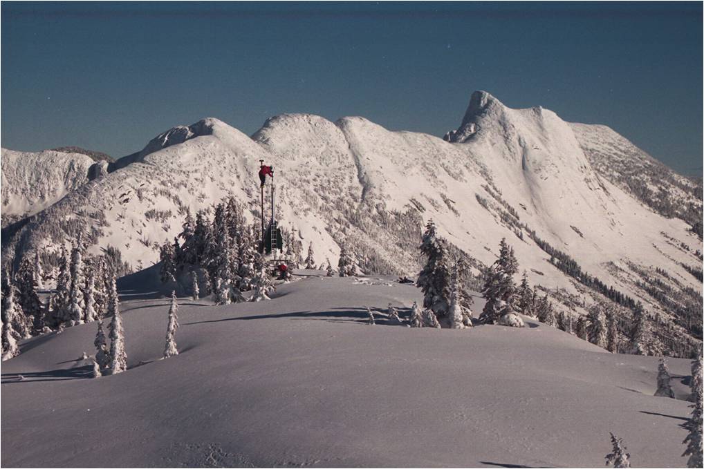
High above the Coquihalla Highway sits the Great Bear Remote Avalanche Weather Station (RAWS). This weather station helps avalanche technicians monitor and develop weather forecasts in their effort to protect the widest snowshed in the province – the Great Bear Snowshed.
In this picture, high above the weather station, one of our avalanche technicians is busy cleaning ice off the station’s sensors.

You may notice avalanche warning signs in your travels through mountain passes such as Kootenay Pass (pictured above). This sign is one of two types used to identify avalanche prone areas. If you spot one of these signs, please don’t stop to admire the view – keep moving for your own safety.
RELATED LINKS:
- Avalanche Control Gets an Intelligent Radar Boost
- Watching the Weather Helps Improve Safety on BC Highways
- How to Keep Traffic Moving in Avalanche Country
- Behind the Scenes: Hanging from a Rock Face for Avalanche Safety
- Seven Things You Need to Know Before Travelling the Coquihalla and BC Mountain Passes
Do you have any questions about this or anything else we do? Let us know in the comments below
Hello,
My name is Drew Carnwath and I am a producer for The Discovery Channel.
I am very keen to feature your avalanche control team for our flagship series “Daily Planet” – seen in over 120 countries.
Feel free to contact me via this email or by phone – 416.821.8103
Thanks,
Drew Carnwath
Producer, “Daily Planet”
DISCOVERY CHANNEL
416.821.8103
Hi Drew,
I’ve passed along your info to our Government Communications group. They’ll follow up with you.