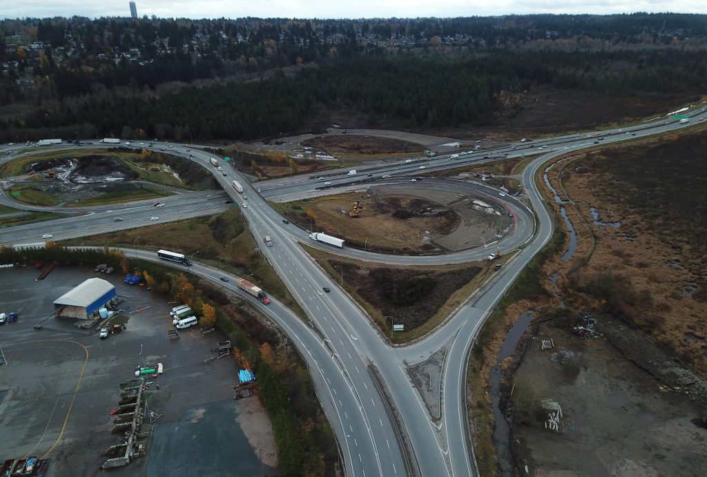
The term “laying the groundwork” gets thrown around in reference to all sorts of activities, campaigns and areas of study. But if you really want to get literal about it, look no further than the Highway 91/17 Upgrade Project in Delta BC.
The project includes upgrades to the existing Highway 91/Nordel Way Interchange and the construction of three new interchanges at the intersections of Highway 91C/Weigh Scale, Highway 91C/Highway 17, and Highway 17/River Road.
That’s a LOT of ground to cover.
Thing is, the project area is close to the Fraser River, which means most of the surface soil is composed of silt and sand – far from ideal conditions for this type of infrastructure. If highway construction were to happen without first “laying the groundwork” in the form of ground improvements, the infrastructure would be at serious risk of instability and future damage.
Ground Improvements: What Does That Mean?
Ground improvements is the term used to describe techniques that consolidate, stabilize, and strengthen soil to meet engineering and design requirements. Simply put, we must ensure the ground will remain stable while bearing the weight of the loads being placed upon it.
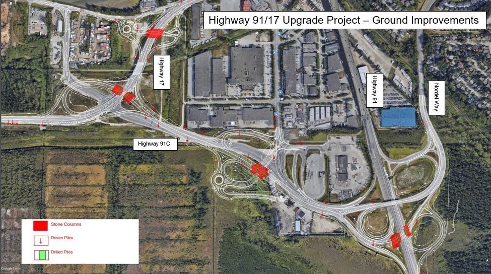
There are three ground improvements techniques our design-builder, Pacific Gateway Constructors General Partnership, is using for the Highway 91/17 Upgrade Project: preloading and surcharging, installing stone columns, and using pile foundations.
Preloading and Surcharging
Preloading and surcharging involve placing fill material, such as sand, on the surface of the ground prior to construction to consolidate – or strengthen by bringing together – the underlying soil.
The surcharging part involves placing an excess amount of fill material to accelerate consolidation. This can take the form of temporary fill embankments, constructed to a height that exceeds the final surface level in the design. These embankments are then cut back to the design level after the consolidation process has had a chance to do its thing, which can take anywhere between two and 24 months, depending on ground conditions and what is to be built on it.
We anticipate a total of 600,000 cubic metres, or 240 Olympic-size swimming pools, worth of sand will be used for pre-load and embankment work.
Stone Column Installation
Stone columns are an effective way to stabilize surface soil composed of silt and sand. The process involves using a vibrating probe to push layers – or columns – of gravel into the ground. The vibrating action compacts the soil and the stone columns create a foundation for the construction project. The builder is installing approximately 2,000 stone columns, varying in depths from 12.5 m to 34.5 m, for the Highway 91/17 Upgrade Project. On average, it takes about two minutes per metre of stone column.
If the process is hard to visualize, this video from sub-contractor Menard Canada Inc. will give you a good idea how stone column installation works:
Pile Foundations
Pile foundations are used when the soil can’t bear the weight of the structure that is being built on top of it without the possibility of the soil expanding, contracting or shifting. Piles can be made of steel, concrete, or wood. For the Highway 91/17 Upgrade Project, the design-builder is installing piles by a pile drilling rig or a vibratory pile driver. Thirty-two reinforced concrete piles will be used in the construction of the project’s bridges/overpasses, and 30 steel piles will be needed for highway overhead directional signage.
Here’s a summary of what all these ground improvements will allow for:
- Highway 91 at Nordel Interchange – upgraded ramps to and from Delta, improved acceleration and deceleration lanes and additional through-lanes for Nordel Way traffic crossing over Highway 91.
- Highway 91 Connector at Nordel Way intersection upgrades – combination of direct access roads and additional turning lanes to remove one signal light and improve all movements, including significantly improved access to and from the Nordel Way commercial vehicle inspection station and truck parking area.
- A new interchange at Highway 17 and Highway 91 Connector (Sunbury) and improvements to the River Road connection – replacing the existing signalized intersection and eliminating the need for an at-grade rail crossing to access the highway.
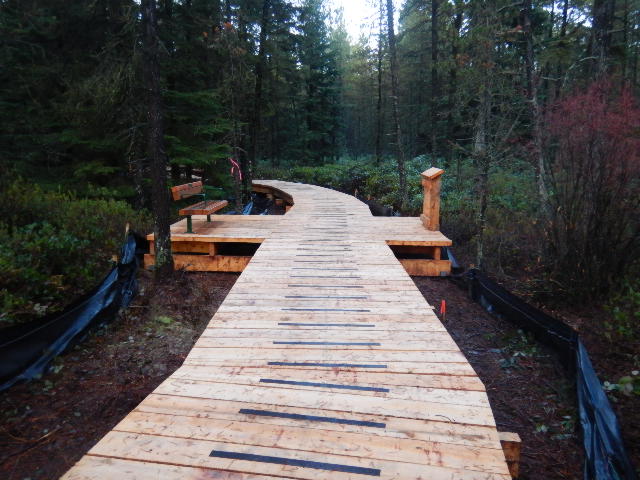
Burns Bog Delta Nature Reserve
With all these major works happening, we know how important it is to maintain the integrity of nearby Burns Bog, which provides such a valuable natural space for local wildlife to live and for people to enjoy.
The design-builder follows construction management plans based on best practices to avoid or minimize potential environmental impacts to Burns Bog, including air quality and dust control, soil erosion and sediment control, as well as protecting vegetation, wildlife and aquatic resources. Meanwhile, we’re doing environmental monitoring to ensure all commitments are being followed – this will continue after the project is finished to make sure long-term environmental protection measures are successful.
We’re also working with Indigenous groups, City of Delta, Metro Vancouver and stakeholders such as the Burns Bog Conservation Society to explore ways to improve conditions, where possible.
You may have already heard that a 170-metre section of the Delta Nature Reserve boardwalk was realigned as part of the project, opening to the public in December 2020. Maybe you’ve already visited it. The new alignment makes features such as the hardhack meadow more accessible and includes four new viewing platforms and four new memorial benches. The realignment provides space for a new vehicle ramp connection between Highway 91 and the Nordel Way Interchange.
We’re excited to watch this project progress and will continue to update you through our social media platforms, including Flickr, where we are regularly posting images in our Highway 91/17 Upgrades Project album. We are also sharing drone flyover videos to show progress. Here is a look at the project as of September 2021:
You can also keep informed about any project-related traffic impacts by checking DriveBC events pages:
For more information about the Highway 91/17 Upgrade Project or to sign up to receive project updates:
- Email: info@pgcgp.ca
- Project construction phone line: 1-866-561-4641
Interested in learning more about our projects that are enhancing transportation infrastructure in BC? Explore these suggested blogs:
>> How the Zipper Truck Will Help Your Alex Fraser Bridge Commute
The person or people responsible for the design of these interchanges should be immediately fired. How this project got approved along the way requires a full scale investigation. The minister of transportation shoukd be impeached and jailed. it is so bad it makes the 200th St. Overpass on Highway #1 look good. Wow.
Hi there, Zak – thanks for sharing your opinion with us here. Is there something in particular you would like to flag for us?
I second that motion. Makes the Los Angeles 10 level interchange look like child’s play.
Seriously, I have never been on a more confusing intersection than this. It was bad before but now it’s worse. I get so stressed out going through there especially during peak hours. The new upgrade don’t seem to make anything better, not for commercial vehicle or personal vehicle. No proper signs are posted when old exits closed or new exits open. Nothing is updated on GPS for people who are not familiar with the area. Simple conclusion, it’s more of an accident prone highway upgrade than anything else.
Hi Jessie – thanks for connecting with us to share your concern. We have shared it forward with project staff and will let you know what we hear back.
Hi again Jessie. The project team recognizes the importance of having clear signage, and is installing new overhead guide signs to help drivers navigate the area as construction on the Highway 91/17 Upgrade Project progresses and new roadway configurations open to traffic. If there are additional locations you identify that would benefit from increased signage, please let us know and the project team will conduct a review. For more information, please visit https://www2.gov.bc.ca/gov/content/transportation-projects/highway-91-17-deltaport/highway-91-17-deltaport-overview/highway-91-17-deltaport-construction-traffic.
We hope this is helpful. Safe travels.
Hey there, highway planners…
“Laying the groundwork” also points to doing something with highway construction to bring housing prices back to normal during a two-decade long Housing Crisis.
In the spring of 2022 house prices are at 7-times over the government affordability threshold, and poised to climb higher to 8-times over by the fall of this year.
How is the Highway 17 improvements “laying the groundwork” to righten the ship in the runaway Housing Crisis?
“Steps to a Strong Foundation”—thinking at the community level, and not just the project level—suggest that a new highway would be a way to move people to new homes, and not just goods.
That would imply that a ‘double function’ is being planned that will add supply to the overheated housing market. A double function that was foremost in mind when Hwy 17 was first planned in 1960.
Yet I can find no documentation of this ‘double function planning’ on the Highway 17 project website. How come? No plans?
Traditionally, highways have been planned on a hub-and-spoke model. The highway is the spoke, the hub is the destination. For Hwy 17 we are told that the endpoints or destinations are the ferry terminals in Swartz Bay and Tsawwassen.
However, the spokes are supposed to accommodate housing all along the way. That is not mentioned.
The preservation of Burns Bog commendable. How is this project proposing to ‘conserve’ our way of life as a community by being a positive contributor to lowering the cost of housing and adding product to the markets?
A question that pre-supposes entails having the new footprints of settlement designed to be in balance with nature.
Again, one commends the construction of a new nature trail. But how about construction for the rest of us? We are suffering under the burden of a Housing Crisis pushing prices to 8-times over the government threshold for affordability by this fall, according to industry analysts.
How about if that nature trail connected two neighborhoos, designed with a net-zero environmental footprint, one at each end? Why has not this type of planning been used?
That’s a LOT of ground to cover. I know. But that’s what Canadians expect from government.
One expects no less from our professional engineers and planners advising government.
Sure, update a highway system to four lanes. At 1,200 people per hour travelling in one direction, we are providing movement for 2,400 people or 400 trips in each direction.
Not a great deal of people movement for all that money. We will offer comparisons to other modes of transportation below. Google gives the overall cost of the project as:
$245 million (just slightly over)
$3.18 million per km (using a 77 km length)
One has to travel to a Wikipedia page to get the project facts:
Length: 121 km (this doesn’t add up: 33 + 44 = 77 km; ferry distance = 75 km)
Existed: 1960 – present (so 1950s planning)
Vancouver Island: 33 km
Endpoints: Victoria Harbour to Swartz Bay
Supported Residential Intensification: NIL (or not reported)
Lower Mainland: 44 km
Endpoints: Tsawwassen to TCH 1; Hwy 15; Golden Ears Bridge
Supported Residential Intensification: NIL (or not reported)
Distance travelled by the Tsawwassen-Swartz Bay Ferry: 75 km
Major Cities: Victoria, Delta & Surrey
BC FERRY CAPACITY & COSTS
$542 million for the three ships ($181 million per ship)
Capacity: 370 vehicles (average 2.2 persons per vehicle or 800 passengers)
Total Passenger Capacity: 1600 passengers (800+ foot passengers—never seen it that full)
150 people – maximum bus capacity arriving every half hour
Ferry Trip: 2.5 hours (allowing for boarding, but not sailing waits)
800 passengers by car
200 passengers by bus
Total BC Ferries Tsawwassen-Swartz Bay carrying capacity
400 pphpd
COMPARISONS
*BC Ferry
$181 million per ship
400 pphpd Passenger capacity
*4-lane Hwy 17 upgrade 2 SOV lanes each direction)
$3.2 million/km
2,400 pphpd Passenger capacity
8-lane highway (3 SOV + 1 HOV lane each direction)
$6 million/km
6,000 pphpd Passenger Capacity
Modern Tram (14 car train set)
$50 million/km
105,000 pphpd Passenger Capacity
Skytrain (maximum 4 car train set)
$200 million/km on viaducts
$600 million/km subway
15,000 pphpd Passenger Capacity: (same for both designs)
*Does not support any additional new housing along the route
Why are we building more road capacity without planning for housing at the same time?
In providing your answer please consider that facts like the Hwy 17 crossing ALR, and sensitive natural reserves like the Burns Bogg, are existing conditions at the time of project planning and funding.
First question is, taking existing conditions as a given, why has the Hwy 17 planning and implementation process failed to deliver housing as part of the long-standing paradigm of constructing highways-and-houses?
1. How is the Highway 17 improvements “laying the groundwork” to righten the ship in the runaway Housing Crisis?
2. When are we going to realize that a 400 people per hour in one direction link between Vancouver Island and the Mainland represents a choke point in our economy?
3. I’ve driven the Hwy 17 corridor and find the signing horrendously confusing. When is BC Highways going to adopt the US highway system of signing (i.e. signing every lane, rather than the exit or destination)?
The lane-signing protocol places a down-pointing arrow over the lane, displaying the destination on top. The BC Highways signs place up-pointing arrows, and bending to the right arrows for exits, creating ambiguity as to whether I am on the right lane or not.
Hello Lewis,
Thanks for connecting with us here. Given the specific and detailed nature of your questions, we encourage you to reach out directly to project staff for the Highway 91/17 improvements project, here: Info.HWY91_17@gov.bc.ca
Project staff may not be able to speak to your housing related questions, but should know where to direct you for more information in that regard.
Hope this is helpful to you.
Current hwy 17 and 91 .the exit off river Rd eastbound to hwy 17 eastbound a second “roundabout” that seems to be triangular in shape and not conducive to normal driving .it doesn’t look to be temporary as red colored stamped concrete is used in it’s construction.what a waste of money !!! A more curved design would be better .I can only imagine a tractor trailer failing this manuever …this must be reworked !!!
Hi there Don,
The red stamped concrete circle area has been specifically built to accommodate tractor trailer traffic as they move around the circle. This apron is meant to allow the trailer to move around the circle (as their length prohibits it). Hope that this information is helpful!