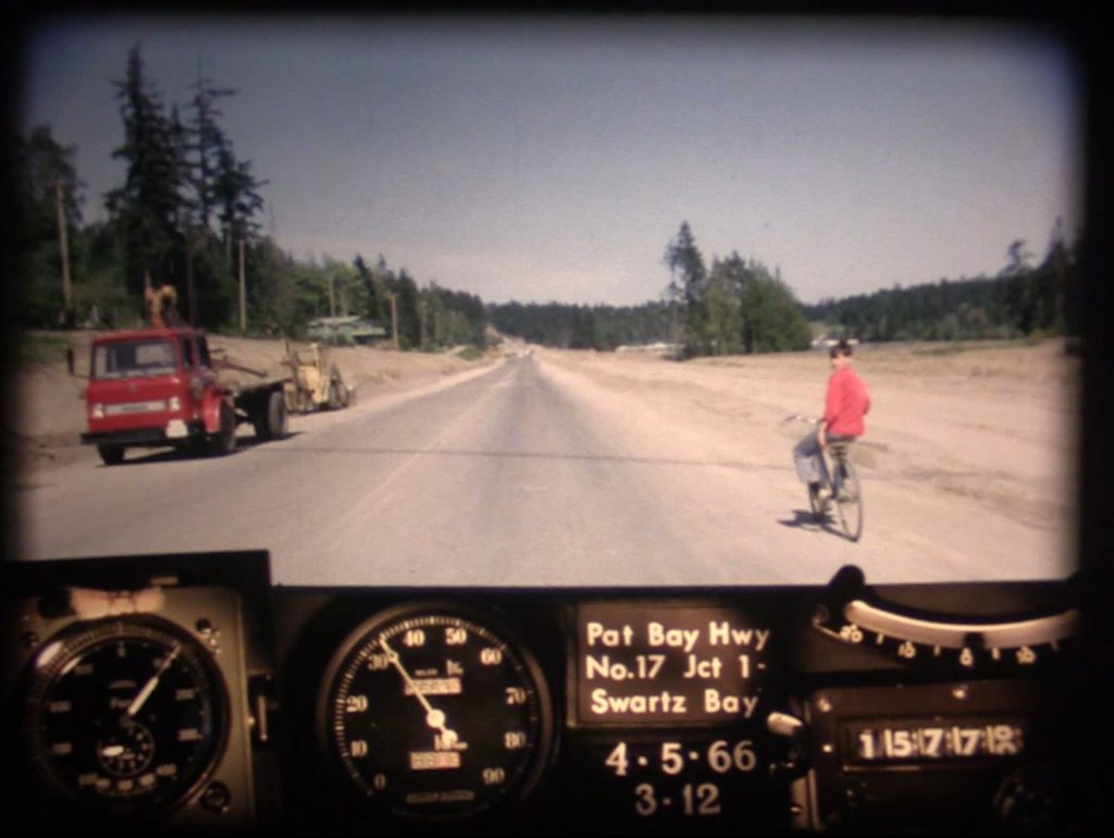
Hey Victoria! Are you ready for your time travel close up? That’s right folks, we’ve pointed our BC Road Trip Time Machine at Highway 17 on Vancouver Island and captured the provincial capital as it was in the spring of 1966. We know you are eager to see it so, hop in and get ready to roll down memory lane.
About Highway 17 (Patricia Bay Highway)
This busy corridor actually consists of two separate highways, one on southern Vancouver Island, the other on the lower mainland, connected by a ferry.
Known locally as the Pat Bay Highway, the island section of BC Highway 17 runs between Victoria and the Swartz Bay Ferry Terminal, north of Sidney on the Saanich Peninsula.
A lot has changed on this route over the years, almost too much to list, so keep your eyes peeled for these video highlights:
- (0:05) Prior to the current alignment separating north and southbound traffic via the Blanshard extension (1978), Highway 17 started on Douglas Street near Carey Road. Before the highway was officially numbered in the 1960s, it was called East Saanich Road along a large portion of the route.
- (0:10 – 0:16) In 1966, McKenzie Avenue was a small rural street with no connection to Highway 1. Highway traffic travelled alongside the Swan Lake/Christmas Hill area, then across McKenzie Avenue, towards Royal Oak. If you look closely, you can see school children along either side of the highway, possibly heading to Pacific Christian School nearby.
- (0:32) Quadra Street joins up with the highway on the right. The Quadra Street overpass, connecting with the Royal Oak shopping area won’t be built until the 1970s.
- (0:36) Junction of Highway 17 and 17A (also known as West Saanich Road). This route accessed the famous Butchart Gardens, as well as the ferry across the Saanich Inlet to Mill Bay. 17A was a formal alternate route through the peninsula. Highway 17A was designated in 1962, but lost its designation in 2000.
- (0:45-0:53) Before the divided highway of today, Highway 17 ran directly in front of Beaver Lake Park, along what is now called Elk Lake Drive.
- (1:00) Haliburton Road on your right
- (1:16) Sayward Road Intersection
- (1:40) Keating Cross Road exit
- (1:42) East Saanich Road continues off to the left
- (1:48) Island View Road intersection
- (2:07) Mt. Newton Cross Road intersection
- (2:40) McTavish Road intersection
- (2:58) Beacon Avenue Intersection and Sidney
- (3:07-3:37) Road widening work to and from Swartz Bay Ferry Terminal
- (3:27) Wain Road intersection
What are Photologs?
“Photologs” were created to capture road condition information across the province and give our engineers the ability to study a particular stretch of road without having to travel into the field.
The original photologs were collected by rigging a camera onto the dash of a car that took still images every 80 feet or so and then running them all together as a single film. Pretty cool, eh? As far as we know, the “Highways Department” (as it was then known) was the first organization in Canada to collect information this way.
Looking back on these old reels reveals a lot more than just pavement condition. The camera installed onto the dash of a car and driven over 9,000 km of BC highways captured some incredible glimpses of our province during the heyday that was the 60’s. So, sit back, relax and watch this glimpse of a world long gone by in the rear-view mirror.
Are you patiently waiting to see footage of a particular BC highway that we haven’t shared yet? Let us know in the comments below. Check out our favourite still images from this film and from other photologs; or, see films of other BC Highways captured so far on our journey. You can also check out some of our other historical content here:
- BC Road Trip Time Machine: Travel Back to Highway 14 in 1966
- A BC Highways Perspective of the Hope Slide
- BC Road Trip Time Machine: See Vancouver as it was in 1966
- See the Construction of the Fraser Canyon Highway in Historical Photos
- Snapshots in Time: Who is the “Highways Department”?
Thank you for posting this Photolog. Wonderful time travel opportunity. Being new to the area and a history buff, great to see how things have evolved and what’s still the same.
Thanks Josepha, we agree!
We moved onto Falaise Cres. in 1958 before all sections of Pat Bay were joined up. The school bus blocks our house. Wonderful place to grow up,open fields, forests to build forts, Beaver Lake to swim in.
🙂 🙂 🙂
Thanks for sharing your memories with us, Gordon. We love to hear them.
Could one of you tell me what year the highway opened between Balfour and Kaslo?
Thanks in advance
Good morning!
While there likely was an unofficial route between Balfour and Kaslo before it became an official numbered route, this stretch was officially designated BC Highway 31 in 1973, Hope that this information is helpful.
Delightful to see no cluster of bill-boards between Island View Road and Mount Newton Cross Road. Not all changes are improvements.
Thanks Jim!
Any chance this can made as a layer on iMapBC?
The digitized 16 mm films that have been released to the public have been assembled as a side volunteer project by certain staff and are not an official activity of the ministry. The data and meta data for the videos have little or no value to the ministry as the core data from which they are derived is not geo-referenced. Also, that archival data has little value for current design or maintenance operations. So, it’s unlikely that this information would ever be made available as a layer for iMap or other mapping services.
This being said, if someone were to make a note of the start and end locations of a video, then plot this as a linear element using, for example, Google’s routing algorithm, then associate the video and its metadata (date, direction, etc) with that linear object…
The only difficulty with this would be that some of the routes would have been realigned since the old photolog was created — in some cases, dramatically.
There might be some opportunity for some citizen volunteer to help out?
great
That was pretty neat.
Glad you enjoyed!
Our family lived at elk lake and in 1971 we along with about 15 other homes were expropriated to expand the hightway and make room for the exicting BEAVER LAKE CRD PART. IT WAS A GREAT UPHEAVL OF OUR FARM AS WE GREW 100,000 MEAT BIRDS. IT WAS STRES ON THE WHOLE FAMILY. I LOVE THE BLACK SWAN CANDY STORE AND ELK LAKE FOR SWIMMING TOOK SWIMMING LESSONS AT THE LAKE AT 7;30 am every saturday. Great smimmers. Love this area. Oh how it has changed
Thanks for sharing your memories, Liz.
Do you have highway 1 Douglas street to the start of the Malahat?
Hi Christian,
Thanks for asking. This is what we have for that area: https://www.tranbc.ca/2015/02/10/bc-roadtrip-time-machine-the-malahat-circa-1966/
What a fantastic trip into the past. I remember when the highway was originally constructed and travel it regularly today. A reminder as to how much things have changed.
Glad you enjoyed it, Paul!
awesome movie brings back memories I was 11 … thanks.. actually still remember like that…
danger