It was the largest known landslide in Canadian history.
The Hope Slide forever changed the landscape of the Nicolum Valley in the Cascade Mountain Range, tragically taking the lives of four motorists who were on BC Highway 3 at the time.
We recently discovered a series of images documenting the incident itself, as well as search and rescue and reconstruction efforts following the slide. As far as we know, only one or two of these images have ever been shown to the public before now.
View the complete set of images on Flickr
A Timeline of the Slide Event
In the early morning hours of Saturday, January 9th, 1965, a snow avalanche blocked the Hope-Princeton Highway, in the Nicolum Valley, just outside of Hope. A queue of motorists on the Princeton side of the avalanche began to collect. Some of them chose to turn around and head back up the mountain, while others chose to wait for crews to clear the slide.
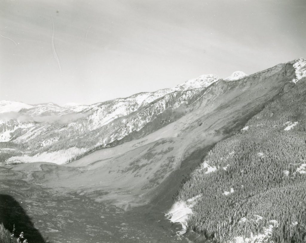
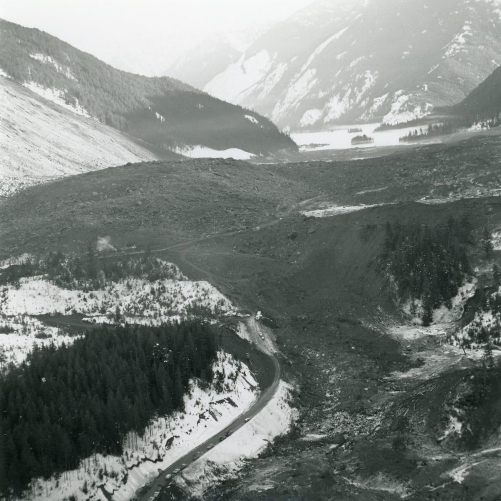
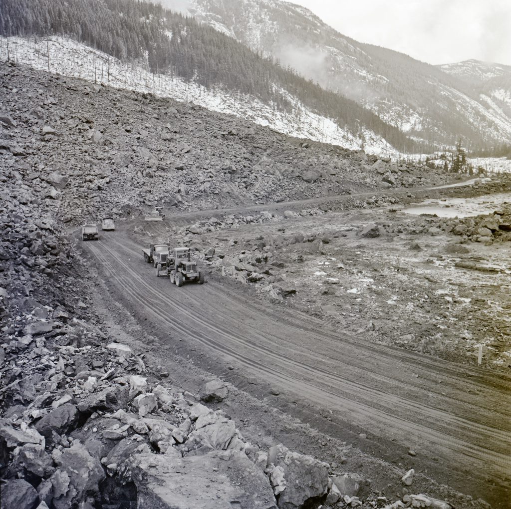
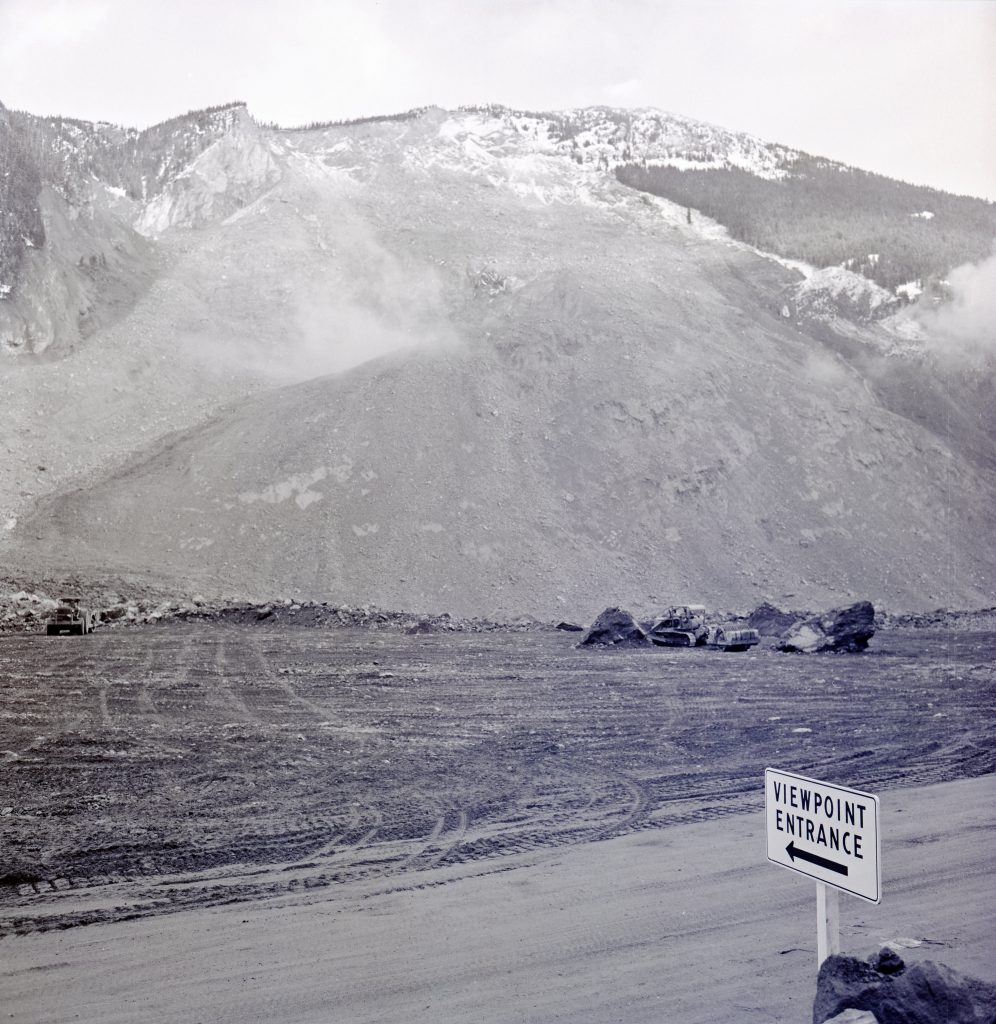
At approximately 7 am, a devastating rock slide occurred at the same location, when half of Johnson Peak collapsed and descended into the valley below. The slide filled the valley bottom with more than 47 million cubic metres of rock, mud, and debris – up to 500 ft deep in some locations. Outram Lake, which had been at the foot of the slide area, was completely displaced. The slide buried a car that had become stuck in the first slide, an oil tanker truck, and a loaded hay truck which had stopped behind the tanker.
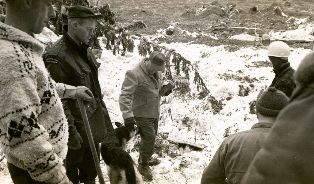
Finally, with the assistance of a search dog, crews were able to recover the bodies of Thomas Starchuck, the driver of the hay truck and Bernie Lloyd Beck, the driver of the convertible. The two other victims of the slide, Dennis George Arlitt and Mary Kalmakoff, were never recovered.
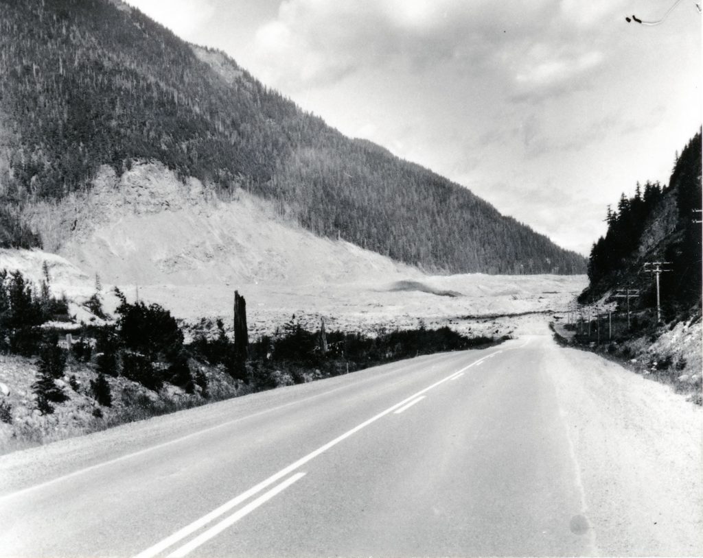
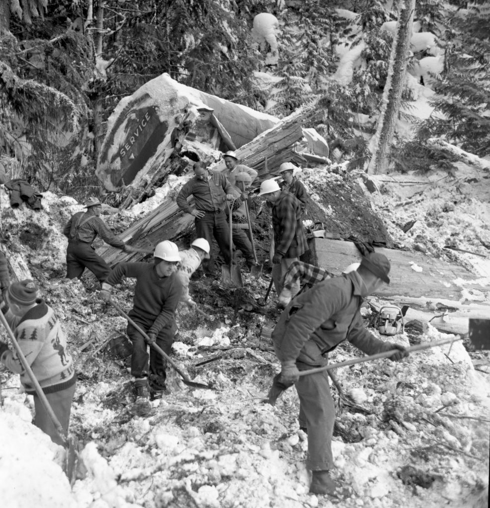
Department of Highways crews worked tirelessly to re-establish the highway connection and in 13 days a drive-able route had been established over the slide.
Related links:
- In the years since the slide occurred, the alignment of BC Highway 3 through the area has changed and developed. Even the slide site itself has begun to recover and is now partially covered in trees – masking the scar that made such an impact.
- View the complete set of images on Flickr
- To get a different perspective of the scale of the slide and the damage it caused, take a trip back in time in our Road Trip Time Machine video and travel the area as it was in 1966, just one year after the slide occurred.
- Interested in seeing more of the ministry’s history in photos? Check out these posts: BC Highway History
Hi there, thank you for sharing these great photos. I’ve been to the Hope Slide a number of times and I’ve always wondered, is the now overgrown road that’s abandoned by the viewpoint the diversion route they’re seen making in these photos? Also, are there any points along the Hope Slide debris field where we can still see the old highway?
Hi Arden,
Glad you enjoyed the photos. This blog post gives you an aerial shot of the old highway alignment and where the new one was rerouted around the base of the debris field: https://www.tranbc.ca/2016/09/22/travel-back-in-time-to-the-hope-princeton-highway-in-1966/ You might also enjoy the Photolog video driving through the area just a year after the slide occurred.
Thanks for connecting with us here.
How did they establish the identity of the two unrecovered victims?
Also, how did they know there were not other vehicles and victims?
Hi Murray,
Thanks for your questions. There is a Wikipedia article on this event which provides more details: https://en.wikipedia.org/wiki/Hope_Slide
Thanks for the history. I heard different stories when I moved to BC. about the Hope Slide .I thick this is more accurate .
Glad to hear you liked it, BRUD. 🙂
As a kid in the late 60’s we drove through the Hope Slide many times. My dad always stopped and we kids jumped out and climbed over all the rocks. My mom would tell us about the bus driver that back his bus out and saved everyone on board. These pictures brought back many memories from my childhood.
Thanks for sharing your memories with us!
I’ve hike/walked to Hope Slide across from Sunshine Valley many times along to old Highway 3. I’ve even hiked/walked on the west side. I think the west side is the temporary road over the slide, and on the east, it was (somewhere) diverted towards the current lookout view, now blocked. Maybe diverted where the current Lakeside Dr ends?
What I can’t find anywhere is an aerial view (map) of the original Highway 3, probably showing the highway tight along the mountain base, between Outram Lake?
Hi there Alan – thanks for your message. You might want to try the BC government historical Air Photo Index: https://www2.gov.bc.ca/gov/content/data/geographic-data-services/digital-imagery/air-photos/index-map-viewer
Hope this helps!
Thanks for the reply 🙂
I couldn’t seem to navigate Google Maps and the index very well but I did find this map which seems to be reasonably accurate when I overlay the lines on a map of the area.
https://4fkwkehyjaa18knruqmhi1qg-wpengine.netdna-ssl.com/wp-content/uploads/2018/10/13732551_web1_180927-ACC-M-Hope-Slide-map.jpg
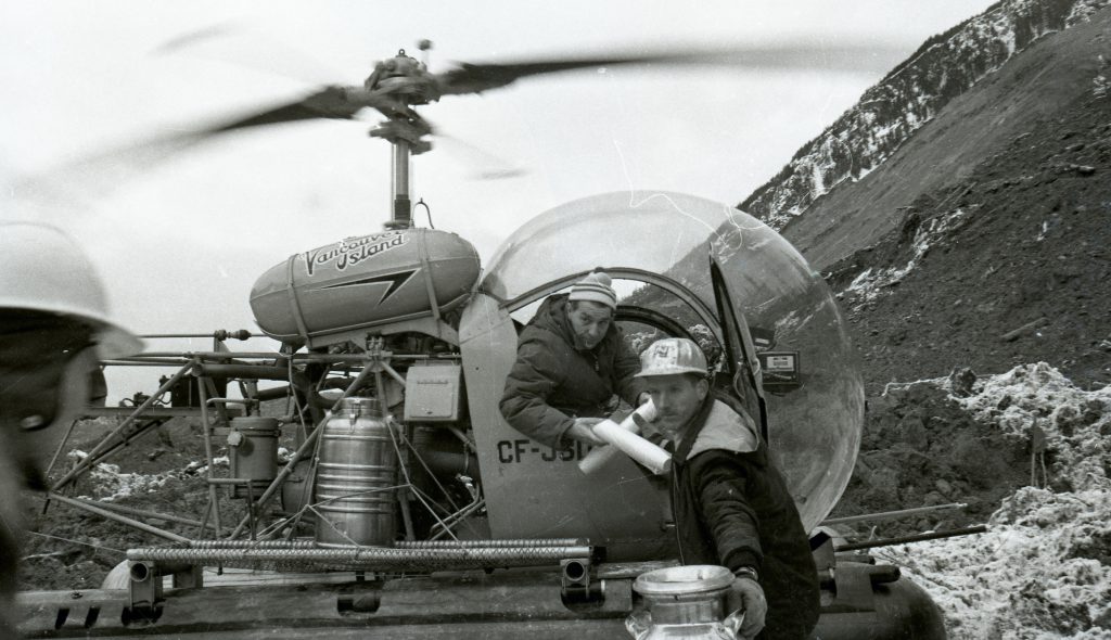
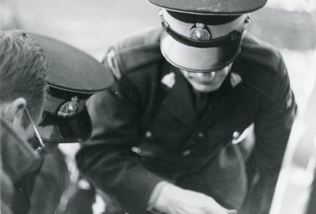
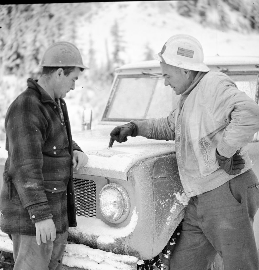
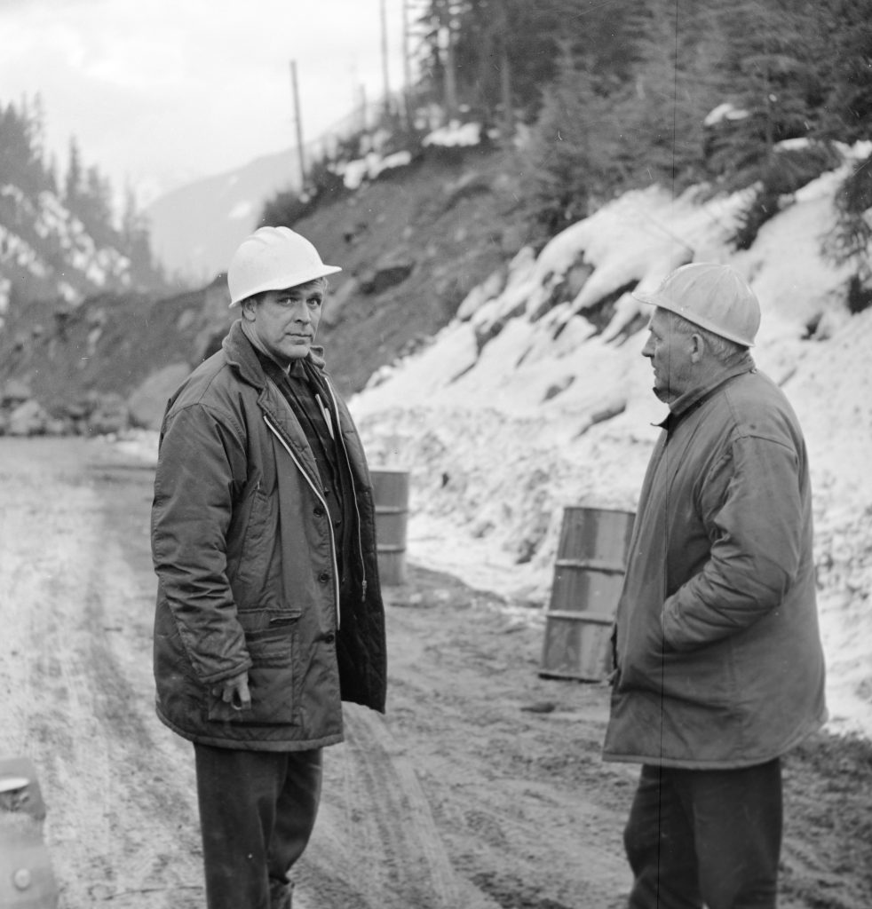
Hi there, These pictures are fascinating. I hope you can help me. In the picture with the two inspectors with white hardhats, can you say more about who they are? I know the guy looking at the camera is forsure my dad. Robert Donald McEachnie. He worked for the Ministry as an inspector for the Board. I reccognize the other guy too but can’t remember his name. My parents history, pictures and such are lost to me. Look forward to hearing from you.
Hello Debra – thank you for connecting with us here. Unfortunately, the images didn’t have names on them. 🙁 We encourage you to view the historical archives of the ministry’s employee newsletter for more information on your dad. Here’s the link to it: https://www2.gov.bc.ca/gov/content/transportation/transportation-reports-and-reference/road-runner-magazine
If you enter your dads name you should be able to find any mention of him in the newsletter that way. We hope that this is helpful. Good luck!
The gentleman on the right is my grandfather, Jack Chalmers.
We have been searching for any photos of the area before the slide. Outram lake in particular. Does anyone have any information on any photos of this area pre-slide?
Hello Mik,
We will keep our eyes open but don’t have anything to share at this time. We hope someone reading this might be able to help or we recommend you reach out the Hope Museum, Yale Museum or even a museum for some of the smaller towns in the Fraser Valley before Hope (Chilliwach, Aggasiz, etc). Good luck with your search!
Was a man named Robert Saucier trapped by this slide? He may have been a passenger on the bus. He was my father.
Thankyou.
Hi Sherron Becker, Thanks for your question about whether your father was on the bus that turned back before the Hope Slide. We do not have that level of detailed information readily available. I believe that it would be complex and time-consuming to seek that historical information from our records, and I expect that the names of those who didn’t die in the slide would not have been recorded by this ministry. Should you wish to pursue that and make a Freedom of Information request, here is some information: https://www2.gov.bc.ca/gov/content/governments/about-the-bc-government/open-government/open-information/freedom-of-information/submit-a-general-freedom-of-information-request I suggest you try some additional sources such as the BC Archives or Hope newspapers.
Are these photos public domain? If not would it be possible to get permission to use them for a documentary series?
Hi Natalie!
The images do belong to the people of British Columbia but use for commercial gain is a bit trickier. Here’s a link to more information on how to do that. If you have any questions, you might want to message us directly (Kristen here).
If you are seeking permission to reproduce all or part of a Provincially-owned material, fill out the Copyright Permission Request Form and we will be happy to process your request. After your request has been submitted and received by our program, we will consult with the ministry responsible for the material to confirm there are no objections to the material being used in the manner requested. If there are no objections, permission will generally be granted. However, if the material will be used for commercial purposes, or the intended use will include modifying the material, a license agreement may be required.
https://www2.gov.bc.ca/gov/content/governments/services-for-government/policies-procedures/intellectual-property/intellectual-property-program/intellectual-property-disposals
Hi, My dad Bob Blumenauer was one of the engineers that worked on the Highway there in Hope. My dad was also on the Alexander Tunnel project as well. I would really like any more information if you have any related to that area.
Hi Michelle,
Thanks for your comment. We will keep our eyes peeled for more historical content in that area, and perhaps it will loop back to work done by your dad. 🙂 Safe travels!
my moms nephew was the driver of the hay truck
Thanks for sharing your connection with us. Truly amazing to hear how many people remember and were linked in some way.
The driver of the Arrow Transfer Tank Truck was Norm Stephinishn [sp] . Norm warned a bus full of people that was behind his rig that rock was still coming down and that they should clear the area which they did and saved a lot of people that day. Norm also rode on the bus to safety.
Thanks for your comments, Don!
My Dad David Hughes was the Greyhound Bus driver that backed all those people to safety.
My father, Roy LeBlanc was a well known photographer and mentioned being at the hope slide.
He was also a personal friend of Mr. Gaglardi’s. I’m curious if some of the photos were taken by him?
Hello Jared – thanks for your message. Unfortunately, none of these images were identified by photographer. Wish we could be of more help!
A follow up story, the year of the slide, was that an RCAF Albatross aircraft crashed into that mountain, when flying in low hanging clouds. I had worked on that particular plane, as a Radar Technician, while in the Force.
Very cool – thank you for sharing with us, Ken! 🙂
There are actually two rock slides on the Hwy-3 Crowsnest Highway…
1) Hope slide near Hope BC and the other
2) Frank Slide in the MD of Crowsnest Pass Alberta east of the Alberta/BC border that occurred in 1903 that destroyed the town of Frank.
Thanks for the comment Richard. Yes, the Frank slide was a terrible event also. As we are the ministry responsible for BC highways, we focussed on the Hope Slide.
I took a walk on the west side of the Old Highway I noticed survey markers along the grown over shoulders. Also a little bit of evidence of machine work out on the rock nearby. I am actually very curious to know if there are plans to preserve that section of the Old Highway.
Hi William – thanks for your question. We have sent it to our local staff and will let you know what we hear back.
Seen your comment
That stretch off road you talk about was a temporary road built in 1966 so traffic could use the road again . Drive from the east edge of slideto see the real original road much closer to the mountain
Not directly related to the Hope Slide, but maybe of some interest to younger readers.
On August 23, 1966, an RCAF Grumman Albatross search-and-rescue aircraft with five air crew members and one passenger aboard was on a routine training flight from home base of Comox to Penticton, in British Columbia, when it became trapped in low clouds and crashed into Hope Slide (the site of a 1965 massive landslide), just east of Hope and about 140 km from Vancouver, British Columbia.
The five Canadian airmen who perished in that accident were:
RCAF Flight Lieutenant Philip Leonard MONTGOMERY,
RCAF Squadron Leader James Leslie BRAIDEN (passenger),
RCAF Flying Officer Christopher John CORMIER,
RCAF Leading Aircraftman Robert Elwood MacNAUGHTON and
RCAF Flight Lieutenant Peter SEMAK.
Captain Robert Reid survived the crash
Thank you for this additional information Grant – yes – this was another tragic loss of life at the site.
I also wrote that story … the Albatross is just one of a number of aircraft that have got into trouble in that airspace and crashed on the face of the mountain. A couple of private pilots have met the same tragic end. I have met Capt. Reid.
Hi Gerald,
I frequently drive through there on my way to/from the coast and always find myself drawn to pull off and simply wonder at the unimaginable forces that reshaped that landscape in 1965.
But further having been a pilot many years ago, the crash of the Albatross and the story told by Capt Reid of how he survived somehow and managed to make his way down in the condition he was in intrigues me to no end. I would love to hike up to the crash site in reverence to those airmen who lost their lives as well as perhaps get a sense of what it might have been like for Capt Reid. I have to presume that there is a trail up there and no doubt that adventurous individuals as myself have done that over the years but I’m unable to find information online giving at least the approximate location etc.
Anyway, thank you for posting this photographic history of the slide.
Thanks for sharing with us Gerald!
I just drove by the slide and was telling my wife that my Dad did an rcaf crash investigation in the mid 60’s there, so I thought I would look it up. He was in charge of all multiple engine plane crashes world wide for the rcaf the last few years of his career. I was 10 at the time living in Ottawa.
I , too, know Bob Reid. He was an RMC graduate and was the Registrar of the UBC Law School for decades.
Drove through this slide area a few times since the slide. These pictures are amazing. Thank you for showing these pictures. Quite a mess. Very interesting, This is historic and I will definitely save them.
Thanks again
Glad to hear your liked them Bob!
Nice and helpful post for me. Thank you so much for sharing.
Thanks for your kind comment Malika.
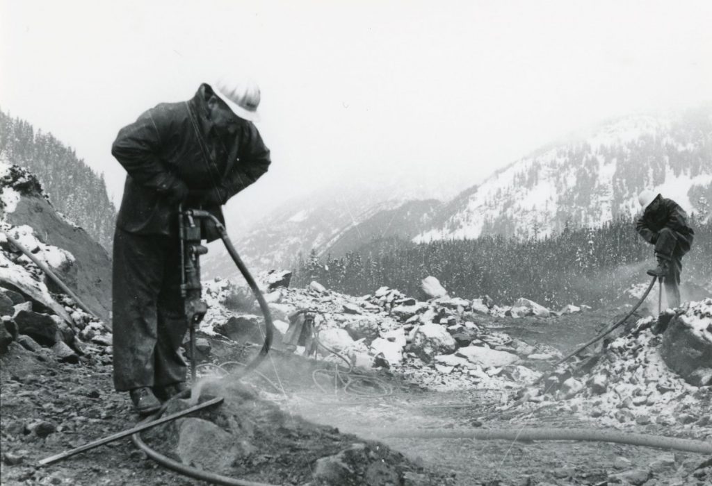
I wonder if you have any more photos of the construction crews? Family lore has it that my grampa was up there drilling and blasting rock for the road. Any photos that show him would be very treasured…
Hi Bill,
Thanks for your message. I can certainly have a look for you. Can I send them any images I find to you at the email address listed here?
Maybe the next one could be the Heather Mountain slide in Glacier National Park (though that bit of the Trans-Canada is federal under Parks Canada Management). It is where the mudslides happen and affect the highway most springs despite the catchment basins and culverts. You can only get a glimpse of it through the trees from the highway. Seen from above (or on satellite images) it is about a 2 km long scar of broken rock below an obvious fault line. Hope if it does go nobody is below it.
Hi Nick – thanks for your comment. Have you mentioned this to the folks in Parks Canada?
They know all about it. There is an engineering report about the slide, which I haven’t seen, and perhaps that is more reassuring than my impression of it. Maybe it won’t come down before the highway is fully 4 laned (i.e. never).
Okay – good to know Nick – thank you.
My father, John Harding, was BC Senior Traffic Engineer at the time and I believe his car is pictured in the one labelled “BC RCMP assisting with recovery.” A Pontiac stationwagon, and I would think he might have been there. There is a person walking nearby away from the camera that we think could be a family member. Remembered by many, being the main route to the eastern part of BC.
Thanks for sharing these.
Thank YOU for letting us know Debra! We are thrilled to hear from folks with such a personal connection to this story.
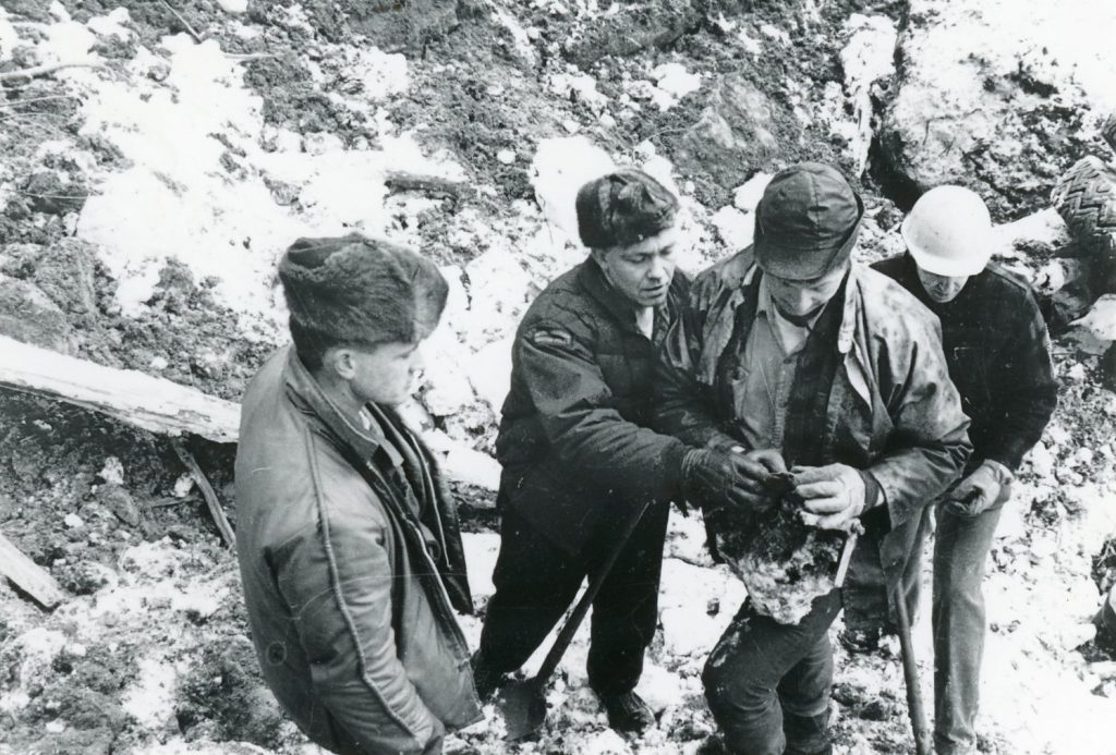
My dad was on the search team (RCMP constable pictured in the 6th photo examining debris). He took many slides of the site and we always stopped at the memorial when travelling by on family holidays .
So amazing to hear this Linda! Thank you for sharing with us.
Hi, we are trying to identify RCMP members in the photos. Any help would be very much appreciated.
Thanks,
Greg
longford1821@gmail.com
The fifth photo from the top (Min Gagliardi with the dog) was printed with the negative backwards. Note the shoulder flash on the RCMP member.
I think you’re right. Good eye.
I remember this very well. Arrived at 5:30 a.m. to do the morning news run at CHWK Radio in Chilliwack. Upon doing the regular RCMP detachment calls Hope RCMP reported they had sent a car to check out a slide up the Hope-Princeton Highway. Called back in a half hour to learn that the whole mountain had come down. Later in the day we had the only on tape interview with then Highways Minister Phil Gagliardi that we fed to news organizations across the country. I was a busy day with the technology of the day.
Hello Gerald – thank you for this recount. We love hearing firsthand from people about this event. It makes it even more impactful and your memory contributes to the story itself. Again, thank you.
Went through there not long after and had to follow a lead car through. It might have still been oneway . What a sight for an 11 year old.
I can only imagine!
I remember the morning my dad was called out to this. He was superintendent of the bridge patrol at the time.
You must mean the famous Norm Wells who was a dear friend and colleague of my Dad Walt Mercer .
The Ministry staff member, second to last picture , looking at the camera is I believe Jim Dennison one of the senior engineers.
I remember this well. I wrote the first news reports of the slide that morning. Working news at CHWK Radio in Chilliwack I arrived at 5:30 a.m. and began the regular police checks throughout the valley. Hope RCMP reported a slide and had sent a car to investigate. Shortly afterwards we learned that the entire mountain had come down. Later in the day then Highways Minister Phil Gaglardi gave us an interview and explained the plan provide a temporary route. It was a busy time providing voice reports and copy — large format reel to reel tape and typewriters.
That would have been hectic, especially in an old school newsroom. Thanks for sharing your memories, Gerald.
Hi, we are interested in licensing these photos for use on Highway Thru Hell. Please contact me to discuss. Thanks for your help!
Hi there Natalie – We’ve just sent you an email outlining the steps to do this. Thanks!
Was there a pullin picnic spot on the mountain side that got covered with the slide. We were out for a family drive two weeks before the slide and stopped and had lunch at the picnic tables. We have always thought that is where we were and would like to get that settled in our minds. Thank you.
Hello Dianne – unfortunately, we cannot confirm if there was a picnic table/rest area at this location prior to the slide. We have not found any mention of it in our research, but perhaps other local folks who read this comment might be able to chime in?
There’s another photo, not shown here, that says ‘am RCMP officer using a metal detector’. It’s not and RCMP officer as the forage cap has no gold band and is the wrong shape. The photos here do show RCMP officers with the right forage cap plus also with the beaver fur hats.
Thank you for this information Greg.
Thanks for this post and these photos!
CBC News is interested in writing a story about them.
Is someone available to talk about the discovery of the photos and the history of the slide?
Thank you,
Chad
Hi Chad – thanks for connecting with us. We’d be happy to talk to you about the photos and the history of the slide. We will respond to you via email with those details.