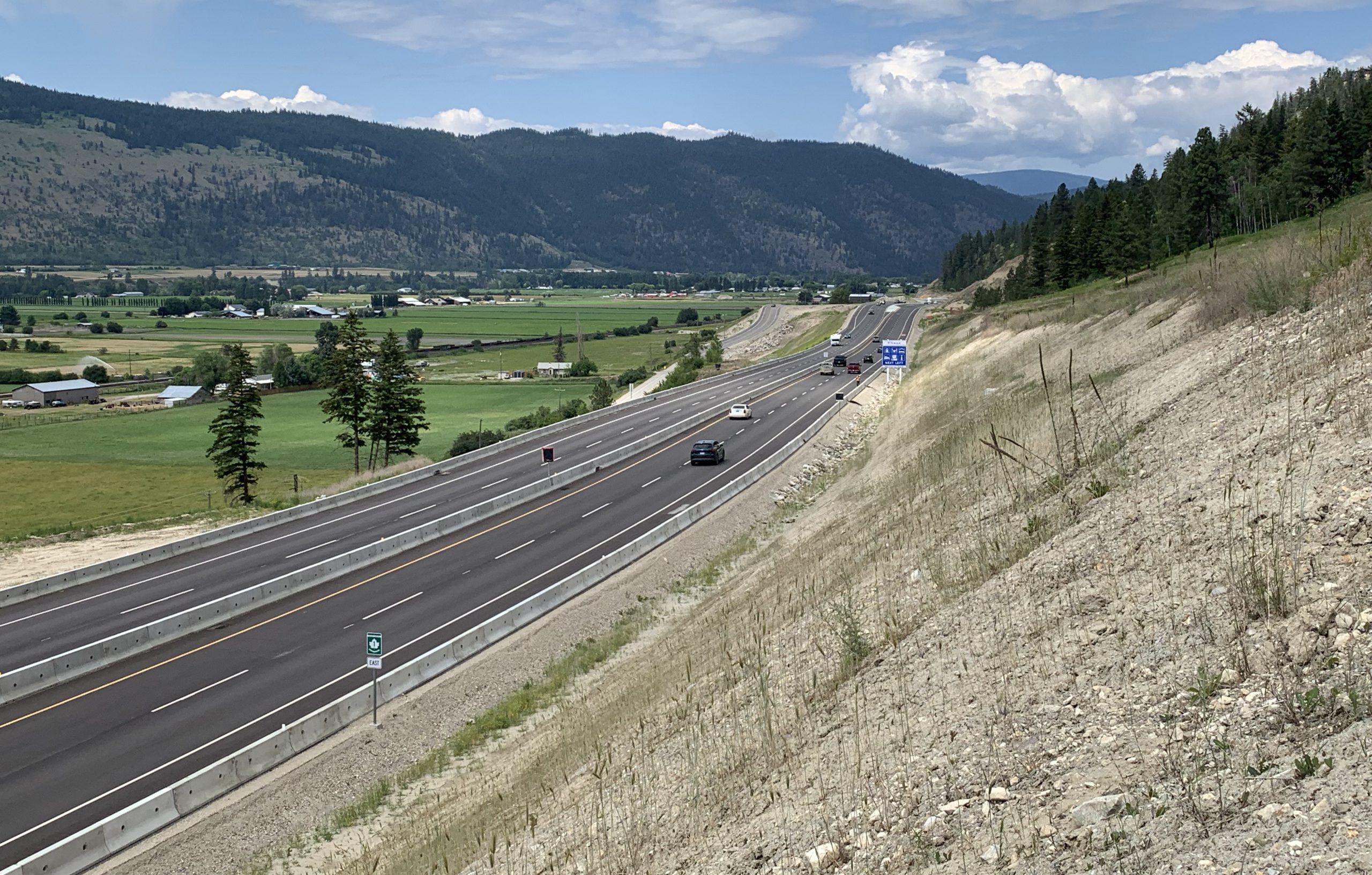
 The Trans-Canada Highway is the primary route connecting BC to the rest of Canada and it’s getting several improvements over the coming years, as a part of our Kamloops-Alberta Four-Laning Program. Much of what makes this route so awe-inspiring also presents some significant challenges during construction. Soaring mountains and rushing rivers don’t leave us much room to work in some spots and that means we will be reducing traffic through worksites or, at times, detouring traffic around them altogether.
We’re doing everything we can to minimize the impact this work will have on travel times along the corridor, but the reality is that delays (and some detours) are inevitable. Despite appearances and even with delays, this is still the most efficient route to take. Here’s what you need to know about what we are up to and why, as well as a reminder to plan ahead and give yourself extra travel time if you will be travelling Highway 1 between Kamloops and the Alberta border over the next few years.
What You Need to Know
We’re monitoring ALL the work happening on the corridor and providing estimated travel delay times via the project update page of the Highway 1 Kamloops – Alberta Border program website. We’ve broken delay times down into four sections (list below), along with estimated delay times for the entire stretch.
- KAMLOOPS TO SALMON ARM
- SALMON ARM TO REVELSTOKE
- REVELSTOKE TO GOLDEN
- GOLDEN TO ALBERTA BORDER
While Kicking Horse Canyon Phase 4 (east of Golden) is substantially complete, the road to final completion includes adding pavement, line painting, wildlife fencing and landscaping. Check for travel impacts and see the traffic calendar.
Delay times listed do not include unanticipated emergency and maintenance activities. If an emergency, such as a traffic incident does occur, that travel delay won’t be captured in our estimated travel times. Like all unexpected incidents on BC highways, you can be assured that we are working hard behind the scenes to get the road open and moving again, just as soon as we can. If you encounter an unexpected delay, check DriveBC.ca for more information on expected delay times, etc.

Local Services
We’re working closely with local communities along the route, such as the Town of Golden, the City of Revelstoke, the City of Salmon Arm and the City of Kamloops, as well as other key stakeholders to make sure travellers can access services, such as food, fuel and emergency services. Many of these local communities have even more to offer tourists and, if you have the time, we encourage you to build them into your trip.
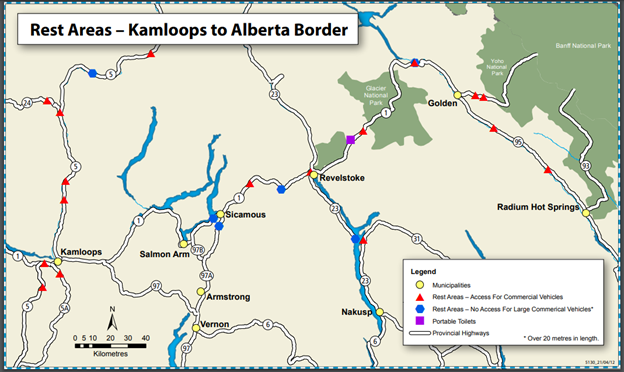
Rest Areas and Wi-Fi
If you need to pull over and just take a break – we’ve got you covered. Some of our Rest Areas along the corridor even have Wi-Fi for you to use. (Wi-Fi is not always accessible on the corridor, so we encourage you to download the map below, in case you need it along the way.) You can also visit our Rest Area website to get detailed information on what other services are available to you at these locations.
Closures to Expect
We know it’s tough but, in order to really “dig in” to the work, some closures will be required. We will be continuously updating the project website and DriveBC with information on closures and delays. There could be extended closures required, along with other overnight and shorter closures and delays, so don’t forget to check the travel advisory page for updates! If you are planning a trip on BC Highway 1, please check these sites for traffic impacts so you can “know before you go”. And don’t forget to follow us on Twitter, Facebook and Instagram to get more info and some amazing photos as these projects move forward!
Info on Highways Through Federal Parks
Did you know that wherever a highway in BC passes through a national park (such as Glacier or Yoho National Parks) the road in that section is the responsibility of the federal government and Parks Canada? We’re working closely with Parks Canada to make sure that any project work or other delays which occur on these stretches of roadway are included in the delay times reported to the travelling public. There are a number of projects which Parks Canada will be completing in tandem with our scheduled project work, in order to minimize the overall impact to the travelling public.
Respect the Construction Cone Zones
All of this amazing work is being orchestrated on the ground by traffic personnel. Please watch for and obey construction zone speed limits and the directions of staff in the cone zone. The BC RCMP will be monitoring the corridor and ticketing for offenses. Thanks for your patience and understanding as we work hard to deliver on these exciting improvements.
Learn more about the Trans-Canada Highway in BC:
- Share and Share Alike: Federally Run Highways in BC
- 4 Unseen Engineering Marvels in BC
- BC Road Trip Time Machine: Lytton to Revelstoke, circa 1966
- What is So Important about Phase Four of the Kicking Horse Canyon?
- Boots on the Ground: A Day in the Life of a Road Area Manager
- Innovative Rockfall Netting System Aims to Improve Safety at Three Valley Gap
- 10 Things You Don’t Know About the Trans-Canada Highway
Will be travelling on Douglas Lake Road this weekend. Do you know if it has lots of potholes/washboard on hills or has it been graded? Thank you.
Hello Carol – thanks for your comment. This page is only monitored during regular business hours. If you have a question about the condition of a particular road or location, we encourage you to reach out to the maintenance contractor responsible for the area for more information. Here is a list of our maintenance contractors by area and ways you can connect with them. https://www2.gov.bc.ca/gov/content/transportation/transportation-infrastructure/contracting-to-transportation/highway-bridge-maintenance/highway-maintenance/contacts#SA01
We hope this information is helpful. Safe travels.
Is the drive BC site working? I have tried to get on the site for two days now.
Hi Sherri,
Yep – it is up and running. Sounds like you might be running into a cached display problem. You might want to clear you cache and see if that helps. You can do a hard reload by pressing Ctrl and f5 or you can go into your browser and clear your history that way. Hope this helps!
Hello..I am travelling from Sundre Ab to Kamloops BC this weekend, I am looking to see if there are any detours on Trans Canada 1 west, but am not able do so so as BC Travel does not answer my question.
Hi Claudia, we provide 24/7 travel information on DriveBC.ca. That should have any information you’re looking for to plan your travel in BC.
Hi, is there any issue that we have to take care (ex, extra gas…), we’ll be traveling from Revelstoke to Banff next July.
Is the Golden to Lake Louise be closed by July 13th ? i’m asking since Maps and my CAA Travel Planner are actually making us passing thru the 95 to go to Banff.
Thank you Daniel.
Hello Daniel,
Thanks for your message. The Kicking Horse Canyon stretch of BC Highway 1 (the Trans-Canada Highway) between Golden and Alberta may be closed to traffic and require a detour next July. At this time, the schedule of closures is not confirmed but this is a large and longer term project which requires lengthy closures. We encourage you to visit the project website: and also to familiarize yourself with our traveller information website, DriveBC.ca.
The Kicking Horse Canyon project team may be able to give you more specific information on next years schedule at their contact email: https://www.kickinghorsecanyon.ca/contact/contact/
Hi I need to drive to Calgary from Vancouver for an important family situation today? Is this possible?
Hi Maya, it depends on when you’re going and what route you’d like to take.
DriveBC.ca is being updated with the latest travel information to help you plan, including essential travel information. I’d suggest checking it before you travel.
We’ve also created a streamlined version that’s updated when there is any major changes to flooding impacts – https://www.tranbc.ca/current-travel-advisories/
Hope that helps.
heading to Kamloops saturday afternoon from calgary, should i expect closures or long delays
Hi Heather – the KHC site will be under an extended, 24 hour closure until October 7 at midnight. The Kicking Horse Canyon page has a calendar of closures and delays listed on their site: https://www.kickinghorsecanyon.ca/construction/calendar/ and we also encourage you to check DriveBC.ca.
Happy Saturday 😊
A serious observation,
Closing kicking horse is understandable, but re-routing traffic to Radium then back to Hwy 1 DURING WINTER MONTHS, is going to be a FATAL ERROR, and I mean that littereally.
I wish I was wrong, but sadly I will be proven correct.
Hello Larry and thanks for your feedback. The winter construction schedule for the KHC is subject to weather conditions during the winter months. The project site will also be subject to avalanche hazard management as well. Our staff will continue to monitor the corridors during this time, to ensure traffic is moving safely. Thanks again for connecting with us here. Safe travels.
Driving from Revelstoke through Golden to Calgary tomorrow. Is there a chance #1 will be closed east of Golden?
Hi there Brian,
Sorry for the delay in this response. The Kicking Horse Canyon project does have some intermittent delays and overnight closures in place. DriveBC.ca posts more information on those events and the Kicking Horse Canyon project page has a month by month calendar of closures and delays, as well. We hope that this is helpful. Safe travels.
https://www.kickinghorsecanyon.ca/construction/calendar/
I plan to drive from Prince George to Whitehorse. The apps are telling me to drive a crazy non direct route.
I would like to drive going through Dease Lake.
Hi there Victoria,
Thanks for this note. We checked in on the Plan Your Route feature and can see this problem. It looks like it is trying to detour you around a scheduled bridge closure event on Highway 37. The details of the closure indicate that the bridge will be open for travel during most hours (see details below). If you are able to plan your trip around these times, you should be able to take the Dease Lake route.
Highway 37 – Highway 37. Bridge closure planned between Bell 1 Bridge and Deltaic Cr Bridge (35 km south of Bell II). Starting Wed Aug 11 until Sat Aug 14. Full closure planned at Taft Creek Bridge between the hours of 7pm and 11:59pm on Aug 11th, 12th, 13th and 14th. Traffic, with the exception of emergency vehicles, will not be able to cross the bridge. Last updated Mon Aug 9 at 11:40 AM PDT. (DBC-32249)
We hope that this is helpful.
Are there any plans for the Sorrento BC area?
Good afternoon Karen. Thanks for your comment. There are currently no projects on the books for the Sorrento area specifically, however there are improvements underway in the Chase area nearby. You can learn more on those improvements here: https://www2.gov.bc.ca/gov/content/transportation-projects/highway1-kamloops-alberta/chase-four-laning?bcgovtm=buffer
Totally appreciate the work that is consistency on improving the service between Whistler and Pemberton. And in Pemberton I walk a lot for my health. The previous government did zero about tidying up the sidewalks, crosswalks and gravel leftover from
winter. Total high five!