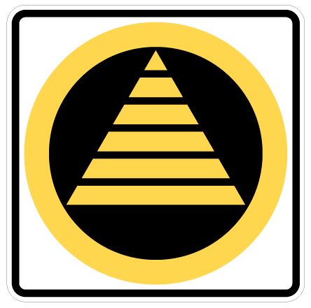
Do you know what this yellow sign means?
Many people who see these signs on Vancouver Island and in the Lower Mainland think they indicate public evacuation routes during an emergency situation, but this is not true.
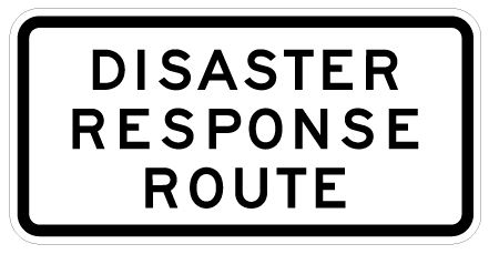
These are Disaster Response Route signs and they indicate routes that are designated for use by emergency personnel only during an emergency situation.
They’re NOT the way to go when you want to get the heck out of Dodge. If you find yourself on a disaster response route during an emergency, exit the route as soon as possible to make way for first responder personnel.
So, what are Disaster Response Routes?
Simply put, Disaster Response Routes (DRR) are network of routes that are best suited to move emergency services and supplies where they are needed in response to a major disaster. DRRs may be activated following a declaration of a local or provincial state of emergency. They are activated only as needed to respond to an emergency or disaster situation and only for as long as needed.
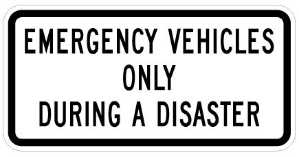
Disaster Response Routes means other roadways can be used for non-emergency traffic, commuting, or the unlikely event of an organized evacuation. Should an emergency, such as a chemical spill, fire or tsunami occur, DRRs will be activated as required and the public will be advised of what routes are open to non-emergency traffic.
Part of a Larger Disaster Response Transportation Network
Transportation is multi-modal – which means the Ministry of Transportation and Infrastructure is responsible, at a high level, for many types of transportation (road, rail, marine and air). Our Disaster Response Route Guidelines include ALL aspects of transportation under the name of Disaster Response Transportation (DRT).
The purpose behind this system is to be able to move quickly to where we need to be…and mobility is the key.
The DRT system is intended to allow all levels of government to align their disaster preparedness plans for more effective emergency response. “Critical routes” will be determined and designated pre-event for resilience planning and priority damage assessment; however, under the new framework, critical routes will be activated with agility to remain responsive during emergency.
Updated Identification System for First Responders on Critical Routes
First responders and emergency personnel were previously given stickers identifying them as authorized to use these essential routes. This identification system has been discontinued and Disaster Response Route permits will no longer be accepted on activated disaster response routes. If you currently have a decal, be aware that they are no longer valid and there are no plans to create more.
Instead, should emergency transportation be activated for emergency responders, other communication methods will be used to clarify and specify who the priority transportation is for. This modernized system will give our highly valued first responders and emergency personnel greater situational awareness to perform their duties safer and more efficiently.
Transportation is a crucial element in response and recovery following a major emergency event. Your awareness and cooperation is necessary to keep these routes clear following an earthquake or other disaster, in the interest of saving lives and protecting property. So, in the event of an emergency – stay calm, listen for updates and please steer clear of DRRs.
Did you like this blog? You might find these related links interesting:
Meet BC SIMS: Our Smart Seismic Infrastructure Monitoring Tool
Where can we find a list of DDRs for Abbotsford?
Hello Sarina,
Thanks for your comment. We suggest connecting directly with the program area staff to see if they have this information: DRR.Info@gov.bc.ca
Hi
How do you apply for this permit/card to be on the emergency route
Hi Taddeo – unfortunately – this program and who gets those cards is currently under review. If you work for an emergency agency – they may be the best point of contact for more information.
Years ago there was a map on this website showing where these routes were so people could avoid them. The map file name was “Lower Mainland-Disaster Response Route Network” 2466-07A 04/24/2008 Perhaps the editor could repost the map
Hello, Anonymous – thanks for your comment. The ministry has recently reviewed its approach to emergency response corridors and going forward, should an emergency, such as a chemical spill, fire or tsunami occur, disaster response routes will be activated as required and the public will be advised of what routes are open to non-emergency traffic at the local level. Hope this information is helpful. Safe travels.
So, why don’t we have emergency evacuation routes?
Hi Bubba,
The general public will be asked not to travel on these routes to allow first responders to stabilize infrastructure and access impacted areas. Smaller side roads will be made available to the public for travel when it is safe to do so but we ask that everyone listen to the radio and television for public service announcements regarding emergency routes and their uses.
What about people that work at hospitals or local agencies that assist in disaster response?
Emergency first responders will be given special permits that allow them to use the routes in the case of an emergency.
Where do I get one of these permits? I am a volunteer firefighter.
Hi Kevin,
We recommend you speak with the Fire Chief about obtaining a permit. There has been a scale back on the number of permits being issued in recent years.