Metro Vancouver drivers are better able to pick the best route for their commute now that the Fraser River Advanced Traveller Information System (Or, FR-ATIS, for short) is operational.
FR-ATIS uses digital message signs at 13 strategic locations to provide up-to-date information about traffic delays on the four major Fraser River crossings:
- George Massey Tunnel
- Alex Fraser Bridge
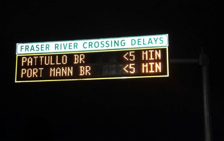
- Pattullo Bridge
- Port Mann Bridge
If you travel Metro Vancouver, you’re probably familiar with the previous digital signs showing the expected total time it will take to travel the crossings. What’s different about FR-ATIS is the way travel time is calculated and communicated.
FR-ATIS shows the current delay across the Fraser River relative to free-flow conditions. Say, for example, it usually takes six minutes to cross the Alex Fraser Bridge, but a stall on the bridge increases total travel time to 26 minutes. FR-ATIS calculates the delay and communicates it to travellers as a 20-minute delay on the digital message signs, along with any delay times of other nearby crossings. These signs are strategically located where drivers can easily change to an alternate route after comparing their options, which helps people make informed choices regardless of the route they use to reach the crossing.
So, where does the delay information come from?
Bluetooth-based sensors collect travel time data throughout the region. These detectors do not collect personally identifiable information but are able to provide the system with accurate travel times across, and in the vicinity, of each crossing. The current travel time is compared with an ideal free-flow travel time to estimate the current delay.
FR-ATIS is another example of how we’re using Intelligent Transportation Systems (ITS) to improve travel in Metro Vancouver and the rest of BC. Other examples of ITS include BC HighwayCams, weather stations, Weigh2GoBC, reversible lane control and Variable Speed Limit Systems.
Want to learn more about ITS? We suggest exploring the following blogs:
>> Have you Heard of Intelligent Transportation Systems (ITS)?
>> How the Lions Gate Counterflow Works
>> How Weight2GoBC Keeps Safe Trucks Moving in the Lower Mainland
Got a question about FR-ATIS or ITS in general? We’d love to hear from you. Drop us a comment below.
These signs can be very helpful, except I’m unclear as to which direction, over the bridges, the delay is! If it notes a 10-minute delay on the Alex Fraser, is that northbound or southbound? I can’t figure that out.
Hello Alan,
Thanks for connecting with us here. The time displayed on the roadside sign indicates the travel delay for vehicles moving in that direction. So, if you’re travelling northbound toward the Alex Fraser Bridge and see the sign, that is communicating the northbound delay to cross. Hope this helps clarify! Safe travels.
So if I’m travelling eastbound on Hwy 17, going under the Port Mann bridge, the sign means what?
Hi there – that would mean that you are looking at estimated delay times travelling east bound. Hope that this helps.
Bluetooth is only a data transmission method, not a data source.
So, where do the Bluetooth sensors get their information?
Hi Don,
Bluetooth devices get their data from available bluetooth signals in smartphone using the route. The more data transmitted and collected, the more accurate the result.
Hope that this info helps!
All Bluetooth devices have a unique ID called a MAC (Media Access Control) address assigned to the hardware (so does Wi-Fi and ethernet) and can be captured whenever Bluetooth is in use.
By having a minimum of two Bluetooth sensors collecting MAC address along the route, you can calculate the average travel speed of a vehicle by comparing the time when a particular Bluetooth passing the first sensor and second sensor.
There is going to be anomalies (i.e.: phone battery running out or taking different route after passing first sensor) but it’s straight forward for the bridge as there is no exit. City of Surrey uses Bluetooth sensors for its municipal roads to show travel times, which are more complicated as vehicle can take detours on local roads.
Thanks, Nor!