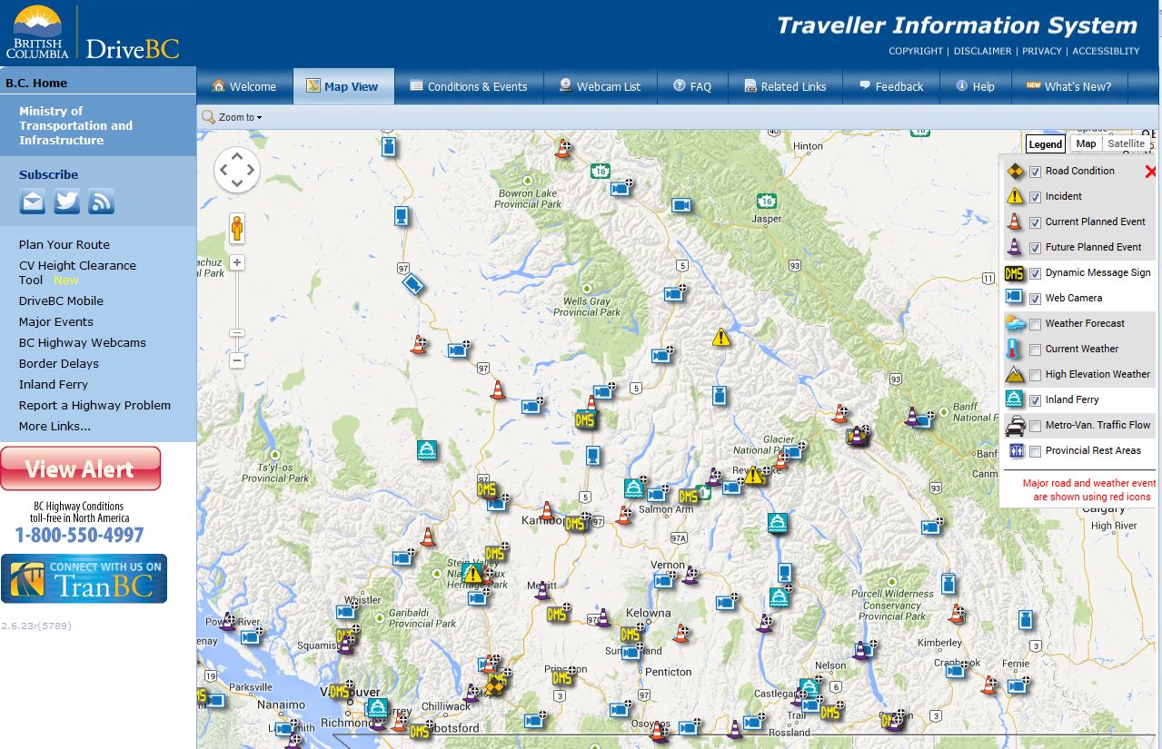
DriveBC is our most popular website and it’s easy to see why. It’s the place you go to find out everything you need to know about road conditions and events across the province and to make informed decisions about travelling, before you head out on the highway.
Some of you have asked us how and when information is updated on the site. It’s a good question and one we are happy to answer (along with a couple of other popular questions). Read on:
1. Where does the information come from?
When an event happens on a provincial highway, whether it’s planned or un-planned, our goal is to get the word out as soon as possible.
Getting and sharing the right information in a timely way means that we have to draw on multiple sources for updates, including:
- emergency services (police, ambulance, fire),
- ministry staff,
- ministry maintenance contractors,
- visual confirmation (BC HighwayCams)
- and – last but definitely not least YOU – the travelling public.
You are one of our most important sources of DriveBC information. That’s why we’ve made it easier for you to report a problem. If you see something that should be included on DriveBC please visit- Report a Highway Problem, to find a contact in your area. You can also find a list of our maintenance contractors and their contact information here. Thanks!
2. How often are events updated on DriveBC?
DriveBC is all about communication and boy is there a lot of communication going on behind the scenes during the lifecycle of an event! Our operations staff, contractors and emergency services are in constant communication during an event to make sure that you have the latest information.
We update DriveBC information every four hours or as conditions change. As soon as there is a development or change in a road condition, it is updated on DriveBC.
The time between receiving updated information and posting updated information on DriveBC is typically around two minutes (that is how often our servers refresh their information). If you are watching our site to see an update and you think your data/image is not current, try refreshing your page. DriveBC does not automatically refresh your screen for you (but we are working on it!) Once an incident or road condition clears, the event is terminated and an “all clear” message is displayed on the website, and a notification is automatically sent to DriveBC subscribers.
3. What kind of events appear on DriveBC?
DriveBC displays information on current road conditions, incidents and future planned events on the provincial highway network.
Wondering which is which?
- Road conditions are weather related events such as fog, black ice, compact snow and freezing rain.
- Incidents are unplanned events that affect the flow of traffic such as police incidents or debris on the road.
- Future planned events are scheduled events that affect the flow of traffic, such as maintenance, special events and construction.
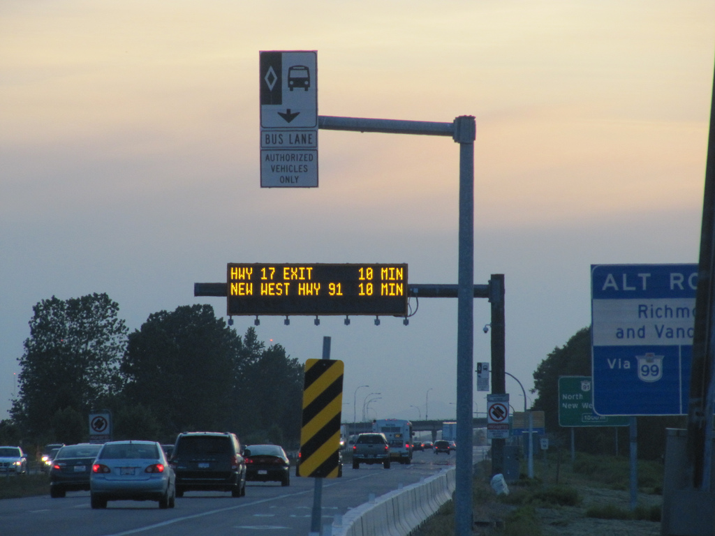
Dynamic message signs found along our highway corridors also display DriveBC messaging and road safety advice and are updated with messaging provided by ministry and maintenance contractor staff as well as our safety partners like police and ICBC who advise us on what BC motorists need to know.
Other Interesting Things You Might Not Know About DriveBC
- We try to keep our messages short and to the point, and if there is a need for more information (such as a longer term emergency situation), we will direct you to a webpage with more details to help you make informed travel decisions.
- If a road condition involves a long stretch of road, events are broken up into multiple smaller sections. We do this because conditions sometimes change in one area and not the other. The multiple events allow us to terminate one and leave the relevant information up for the other areas.
- The map on DriveBC does not show linear events (events that stretch out over multiple kilometres), so it is common practice for staff to input a road condition at the “end” point of an event.
- We work in partnership with Parks Canada to report events on Federal Sections of Provincial Highways.
You can get the latest information on DriveBC by visiting the website, following @DriveBC on Twitter, calling our toll free phone system (1-800-550-4997), subscribing to receive notifications via email, Twitter, text message or RSS feed. More of a visual learner? Check out our DriveBC tutorial playlist on YouTube.
We are always looking for ways to improve DriveBC and your comments help us better understand ways to do that. Submit your comments through the DriveBC feedback portal or by leaving a comment below.

Out east, our highways and freeways all have numbers but also have names. For example the 417 in Ottawa is called the Queensway and we all know what it is. In BC, especially in the lower mainland, the highway system is very confusing. There are no names for the roads. Its Highway 17, or 99, and Highway 1 changes its name three times through metro Van: Highway 1, Upper Levels, Sea to Sky etc. Its very confusing. Is there anything in the works regarding highway naming conventions? Also, Ontario has had those dynamic messaging signs for 30 years. The Ontario Ministry of Transportation has studies and deskbooks available on the best use for those signs. I suggest the BC team check them out and rip what Ontario does for their dynamic messaging. It does nothing for road safety or peoples lives or transportation of goods to have a sign with a message that is constantly stuck on Highway 99 to border 10 min. During rush hour, the signs should read how long the wait is to go through the Tunnel, long before the last exit so people can take an alrernative route should they need to.
Hi Michael,
Thanks for connecting with us here and for your comments. We shared your comment with our Traffic Engineering branch who gave us the following information for you.
Many highways in BC have local names. Here in BC (to name a few) we have names like the Nanaimo Parkway, Crowsnest Highway, East-West Connector, Pat Bay Highway, Lougheed Highway, Sea-to Sky Highway, Old Island Highway, Jubilee Parkway, etc., etc., etc. However the BC Ministry of Transportation and Infrastructure focuses most of its attention on the unfamiliar user rather than the local user and, as such, we follow a numbering convention that is readily mapable.
We are happy to confirm that we use our dynamic message signs to promote safety messaging and public messaging. We also have a program in place which posts the wait times at the border crossings as well as a travel time system for the George Massey Tunnel and the Alex Fraser Bridge on Highway 99 in Richmond and Delta. We hope that this helps answer your questions. Safe travels.
I just want to say thanks for all your hard work. Being a trucker, I rely on DriveBC constantly this past winter, and my trips went for the most part smooth through BC-AB corridor.
Thanks again
Thanks MG, we like that you like it!
It does not appear the ministry updates information on the website in a timely fashion when it is info received from the public. On June 13th, I reported that the rest area on the Malahat Summit was now closed because of the construction occurring there. I received an email back on June 16th that the DriveBC team was currently in the process of upgrading the rest area information.
As of today, July 28th, the DriveBC website still shows this rest area as “open year-round” when it is clearly closed, and will continue to be for the unknown length of time due to the major construction.
There has been more than enough time for this info to be confirmed by emergency services, a ministry employee and/or by the ministry contractor responsible for highway maintenance.
How can you consider the info on the site to be updated in a timely manner if you are not going to use input from the public?
I do not envy a travelling member of the public who has carefully “planned their route” using the DriveBC website, only to be surprised when attempting to stop at rest facilities advertised by the ministry.
Thank you for your time.
Thanks for the feedback Kristina. We are looking into this right now for you. Stay tuned.
Thanks again for sharing this feedback with us. This is our first year providing the rest area information to the public and we are looking into finding different ways to communicate temporary rest area closures. We appreciate your help identifying areas which need more work.
In the meantime, you can find current information about rest area closures on the DriveBC events tab. The closure should also show up in our Plan Your Route option.
There is a notice on DriveBC (which you will find communicated as a DriveBC “construction event”, due to the fact that the rest area is being impacted as a result of the construction project currently happening there) advising the public that this rest stop is closed until winter 2014,
“Construction Highway 1 on Vancouver Island Northbound – The Malahat Summit Rest Area will be closed for the duration of Malahat construction through Sun Nov 30. Rest area will re-open in winter 2014. Updated on Tue Jun 10 at 4:07 pm PDT. (ID# -48248)”
We hope that this helps!
Yes and no. While it is good the info is in the events tab and is indicated as a “construction event”, it is still mis-leading for the rest area layer to indicate the rest are is “open year-round”.
Thank you for your time.
Agreed. We will be reviewing how we can update that information going forward. Thanks again.
Wow!
Truly incredible piece of work. I am proud of MOTI…
Glad to hear that Aman!