It was an event unlike anything we’ve ever experienced here in the Ministry of Transportation and Infrastructure.
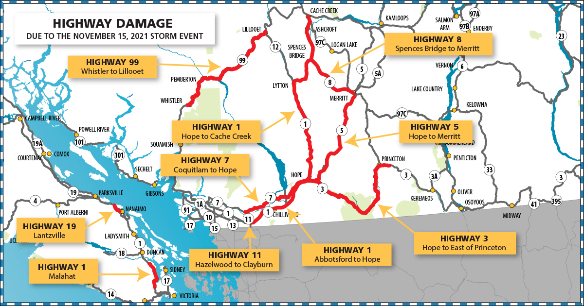
When an atmospheric river brought an unprecedented amount of rain to the province in November 2021 – BC highways 1, 3, 5, 7, 8, 11, 19 and 99 were heavily impacted – with heavy rain creating slides, undermining the roadbeds and cutting off access routes into and out of the south coast of the province. Since then, we’ve been hard at work to restore connections and create new working linkages with local governments, Indigenous communities, and stakeholders both locally and through the B.C. Highway Reinstatement Program to discuss potential long-term transportation solutions at each project site. Following the extraordinary work done to reconnect these highways in December, we are building back permanent infrastructure that will be equipped to better withstand the impacts of climate change and future extreme weather events.
Our thanks to every single person who has been involved in helping us achieve this monumental work. To mark the one-year anniversary of the event, here’s an update on where we are on our journey towards recovery and a more resilient BC highway system.
BC Highway 1 – Vancouver Island – Malahat
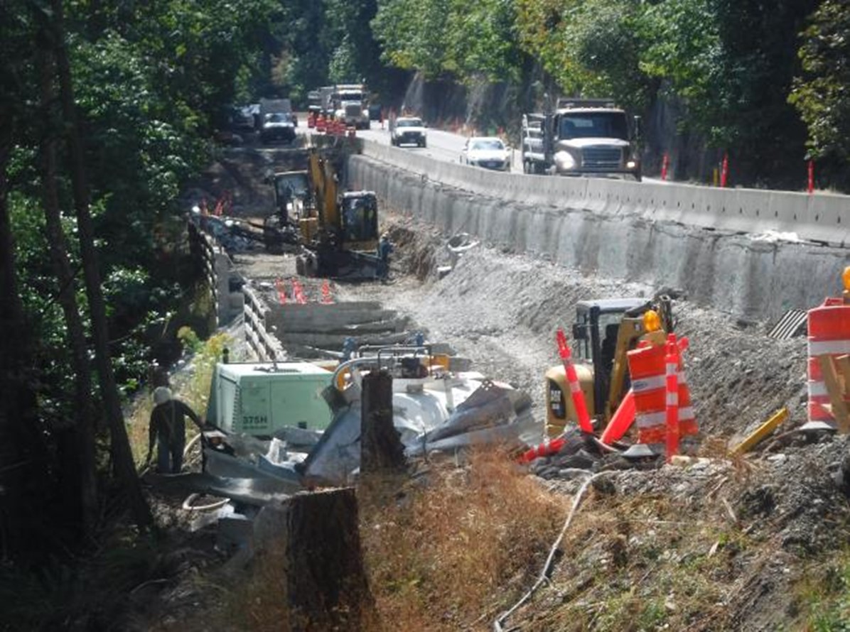
Summary of Impacts – A drainage failure at the Tunnel Hill section of the Malahat resulted in washout that severely undermined the slope and compromised 50m of the northbound lane (temporarily disconnecting South Vancouver Island from Central Vancouver Island).
Areas of Focus for Recovery – Temporary repairs were made immediately following the November flood event to restore connectivity on Southern Vancouver Island.
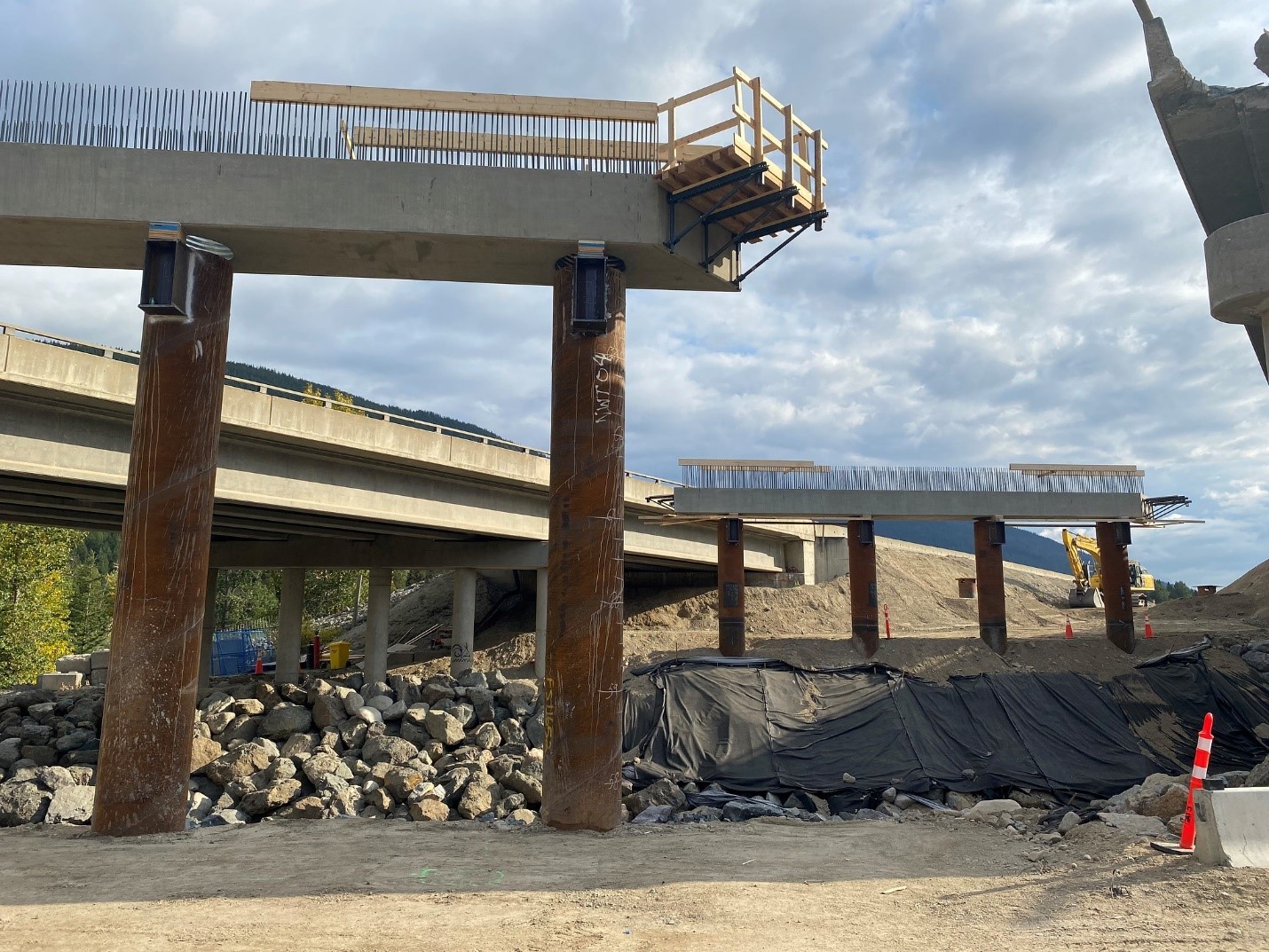
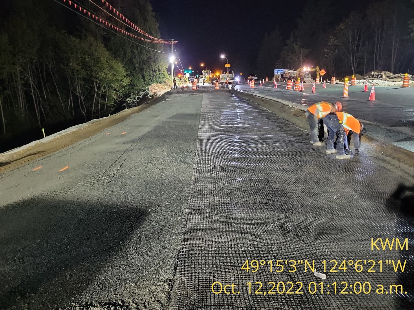
Areas of Focus for Long Term Resilience – A contract was awarded in May for the permanent repairs. The permanent repairs (which began in July 2022) includes restoring approximately 50 metres of the northbound lane, replacing an 80m long retaining wall to secure the slope for seismic stability and address drainage capacity (including projected increased flows for climate change) for the design life of the infrastructure to protect against future extreme weather events. The replacement of the 80m long retaining wall (bin wall) with a 100m long cast-in-place concrete wall requires 84-piles with tie-back anchors and reinforcing steel (742,000kg of steel).The permanent work requires temporary shoring to stabilize slope to remove the existing wall, installation of piling and tie back anchors, construction of the new wall, and then re-establish the roadway; all while maintaining detour for 35,000 vehicles a day.
Get more information and updates on our work to repair and improve BC Highway 1 – Malahat
BC Highway 1 – Fraser Valley
Summary of Impacts – Flooding along the highway through the valley primarily damaged roadside and drainage infrastructure when large volumes of debris and water covered the roadway.
Areas of Focus for Recovery – Removal of large debris slides and restoring damaged roadside and drainage infrastructure were made immediately following the November flood event to restore connectivity between Abbotsford and Hope.
Areas of Focus for Long Term Resilience – Highway 1 through the Fraser Valley is an essential corridor for goods movement in and out of the Lower Mainland and our ministry plays a critical part in the system response necessary to address the flood concern in the Fraser Valley. We are in the process of engaging with local communities in this area as a part of the BC Flood Strategy to help determine best practices for flood safety risks. A multi-agency team made up of local First Nations, the City of Abbotsford, multiple provincial ministries (EMBC, Forestry, Transportation, Agriculture), the federal government as well as Washington State officials, is looking at long-term plans for the Fraser Valley/ Sumas Prairie to develop a local flood mitigation plan and the ministry will be using that work to help inform future upgrades of the Highway 1 corridor.
BC Highway 1 – Fraser Canyon
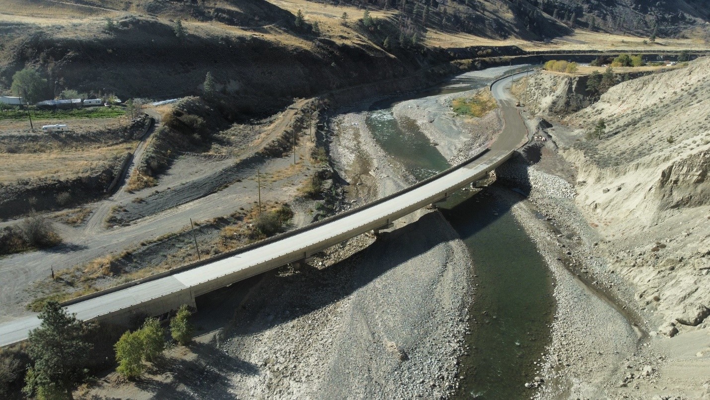
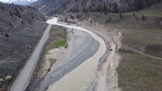
Summary of Impacts – Flooding and washouts associated with the November rains damaged 18 sites along the Highway 1 corridor between Hope and Spences Bridge, including two bridges, one CP Rail underpass, two major culverts and 13 additional washouts.
Areas of Focus for Recovery – temporary repair works (including the installation of temporary bridges at Falls Creek and Nicomen) have restored access along this corridor.
Areas of Focus for Long Term Resilience – Three contracts for development and early construction work for permanent repairs have been awarded for repairs to the Falls Creek Bridge, 55 kilometres south of Spences Bridge; the Tank Hill Crossing, 23 kilometres south of Spences Bridge; and the Nicomen River Bridge, 19 kilometres south of Spences Bridge. The construction work to return the highway to the previous capacity will begin in fall 2022 and is expected to be substantially complete in 2024.
Get more information on our work to repair and improve BC Highway 1 – Fraser Canyon
BC Highway 3
Summary of Impacts – Washouts and slides impacted multiple points between Hope and Princeton during the flooding event.
Areas of Focus for Recovery – Road resurfacing, embankment armouring, base and shoulder repairs were completed during the construction season of 2022.
Areas of Focus for Long Term Resilience – Work is underway at multiple locations, including the Cambie Bridges and the Clarke Slide area, west of Penticton to build back better.
Get more information on our work to repair and improve BC Highway 3
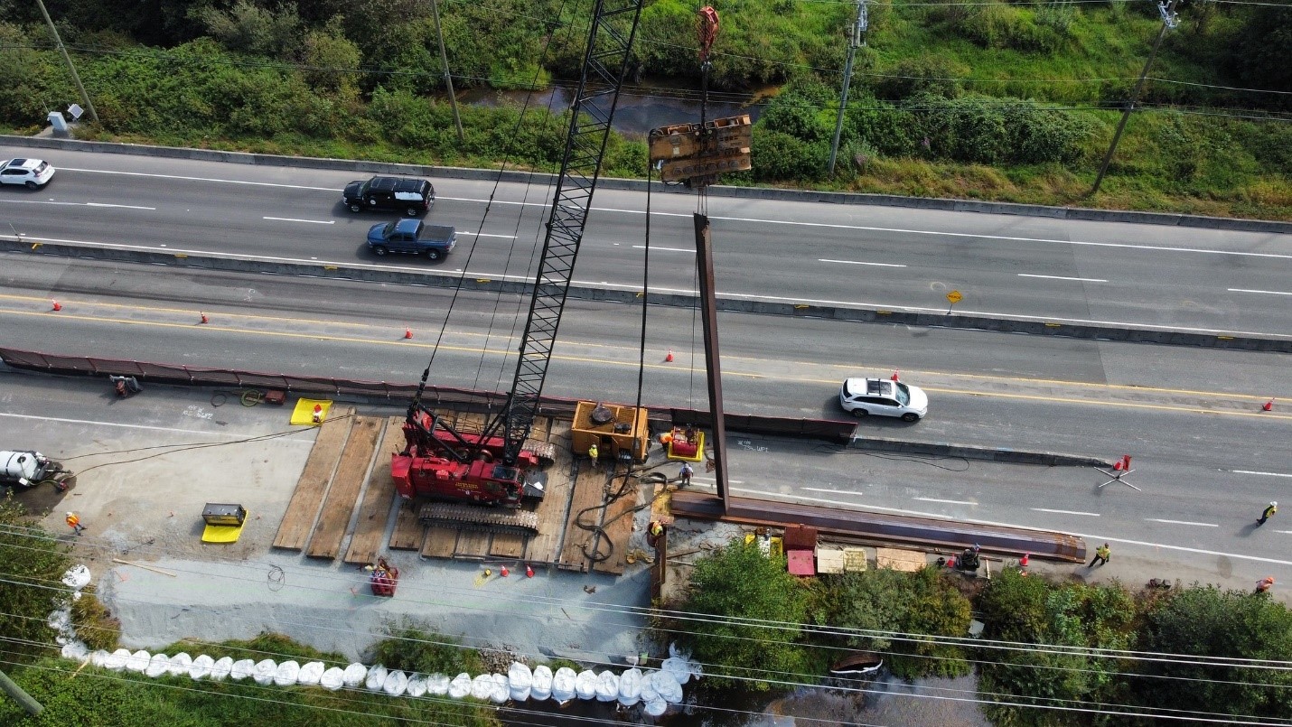
BC Highway 5 – Coquihalla
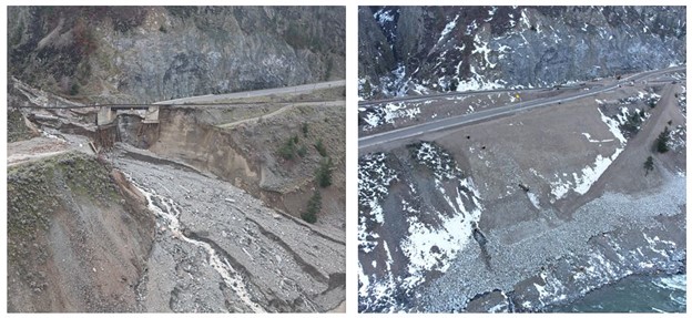
Summary of Impacts – Flooding and washouts associated with the November 2021 rain damaged more than 20 sites along 130 kilometres of the Coquihalla Highway between Hope and Merritt, including seven bridges where spans collapsed or were otherwise heavily damaged.
Areas of Focus for Recovery – Permanent repairs to the Othello section of the Coquihalla Highway 5 are complete, helping rebuild the highway to a more resilient standard following significant damage from last November’s storms. Crews reinstated approximately 460 metres of the southbound lanes that were washed out, as well as:
- replacing and upsizing culverts to accommodate future extreme weather events related to climate change
- shoulder widening and barrier placement
- reinstating the roadside barrier and spillways
Areas of Focus for Long Term Resilience – Early works to repair flood-damaged sections of the Coquihalla are well underway at three sites: Bottletop Bridges, Juliet Bridges and Jessica Bridges. These sites will be four lanes this winter and will remain four lanes through construction.
Get more information and updates on our work to repair and improve BC Highway 5
Watch this inspiring video highlighting the incredible teamwork that helped reconnect BC Highway 5 .
BC Highway 7
Summary of Impacts – During the flooding event, a significant slide occurred at Seabird Bluff and multiple points on the road were subject to erosion damages.
Areas of Focus for Recovery – Following the flooding event, the removal of slide debris and stabilization of erosion along Highway 7 were completed to allow travel to resume.
Areas of Focus for Long Term Resilience – Preliminary geotechnical and hydrotechnical assessments have been completed at the Seabird Bluff site, with designs scheduled for completion by Winter 2022 and construction anticipated to begin Spring 2023. Sterling Road erosion long term mitigation is underway and expected to be completed by Winter 2022. All other sites on Highway 7 have been completed.
Get more information and updates on our work to repair and improve BC Highway 7
BC Highway 8
Summary of Impacts – The storms completely washed out 25 sections of Highway 8, leading to the complete closure of the highway between Merritt and Spences Bridge. Additionally, a severe precipitation event in August resulted in debris flow which impacted 5 sites on Highway 8 and required repairs.
Areas of Focus for Recovery – Thanks to the work of dedicated crews on Highway 8, access has recently been restored throughout the corridor, which has allowed all previously isolated residents to return home by road. Temporary repairs have been completed at all 25 Atmospheric River Event sites, as well as the additional 5 debris flow sites. After nearly a year-long closure, Highway 8 reopened to the public on Wednesday, November 9. Areas of Focus for Long Term Resilience – We are working on forecasting a long-term repair schedule for the phases of work to come.
Get more information and updates on our work to repair and improve BC Highway 8
BC Highway 11
Summary of Impacts – The Willband Creek section of Highway 11 suffered surface and roadbed damages following the flooding event of November 2021.
Areas of Focus for Recovery – Temporary repairs were completed in February 2022 to allow the re-opening of all four lanes.
Areas of Focus for Long Term Resilience – Work continues on Highway 11 to strengthen the roadway resiliency against extreme weather. As Highway 11 runs through a flood-plain in this area, it is the priority to ensure any future floods have a minimized impact of the safe and secure passage along the corridor.
Get more information and updates on our work to repair and improve BC Highway 11
BC Highway 19
Summary of Impacts – The atmospheric river event caused erosion around a culvert under Highway 19 near Lantzville, resulting in a failure of the asphalt surface and creating a sinkhole.
Areas of Focus for Recovery – A temporary repair was put in place to re-open the highway to traffic immediately after the event.
Areas of Focus for Long Term Resilience –Throughout the summer of 2022, work has been underway to install a larger culvert system, improve drainage under the road surface and on the downhill slope adjacent to the highway. This resiliency work will make the highway less vulnerable to damage from run off and extreme rain events.
Ways We Are Tackling the Impacts of Climate Change on our Infrastructure
Since 2015, the ministry has had a policy that all highway infrastructure designs must consider future climatic events. Our design engineers and consultants must consider what can be done to make our roads and bridges more resilient, so they remain reliable and open, over the entire design life of our infrastructure. This policy applies to new infrastructure, rehabilitation work on existing infrastructure and repairs to damaged infrastructure, such as what occurred on highways 1, 5 and 8.
Recognizing that the science of adapting infrastructure to climate change is relatively new and still evolving, we are constantly learning from each event that occurs, and the November 2021 event has given us new data to consider as we review and enhance our policy to be even more resilient to future climate events. We have partnered with groups like Engineers and Geoscientists BC to create guidelines to assist designers, and the Pacific Climate Impacts Consortium at the University of Victoria, in providing future climate modelling for designers to use as they consider future climate events. All of this work will help BC’s highway designers create infrastructure that will be more resilient to future climate events. Examples include:
- pile driving bridge footings
- upsizing culverts
- bridging areas of concern where culverts are no longer suitable
- redesign of drainage channels for future flow
- better armouring of slopes
It’s been a long year and all of this work would not have been possible without the help of so many people across the province, stepping up to the challenge. Thank you. This is the beginning of a longer journey toward rebuilding impacted highways to ensure BC can continue to move in the face of any challenges that may lie ahead. If you found this content interesting, you may want to check out these related links:
Three Ways We Are Working to Protect BC Highways from Climate Change
A closure of the Malahat does not necessarily cut the Victoria area off from the rest of the Island, as there are at least four available detour routes in that case: The Brentwood Bay–Mill Bay ferry, Saltspring Island, the Pacific Marine circle route, and Metro Vancouver.
And we are lucky the problem on highway 19 occurred where it did. If it were to have happened just 5 km to the west, just beyond the Snaw-Naw-As First Nation land, and the problem led to that portion of the highway being completely closed, in both directions, the only available practical detour for motorists between Parksville and Nanaimo would be via Sechelt.
Thanks for your comment, David.
It is all well and good having “a policy that all highway infrastructure designs must consider future climatic events”. However how does that help on sections of Highway 1 that are already 60+ years old and have culverts and bridges that have repeatedly been proved inadequate to deal with existing climate conditions, resulting in road closures? Especially as some of these sections probably won’t be upgraded until the 2060s at the rate that the Kamloops to Alberta program is proceeding.
Hi Nick
We require consideration and evaluation of any vulnerability associated with future climate change and extreme weather to be included in our infrastructure design work. This applies to new projects as well as rehabilitation and maintenance projects – which means we are considering appropriate climate adaptation over the entire design life of our infrastructure. Hope this information is helpful. Safe travels.