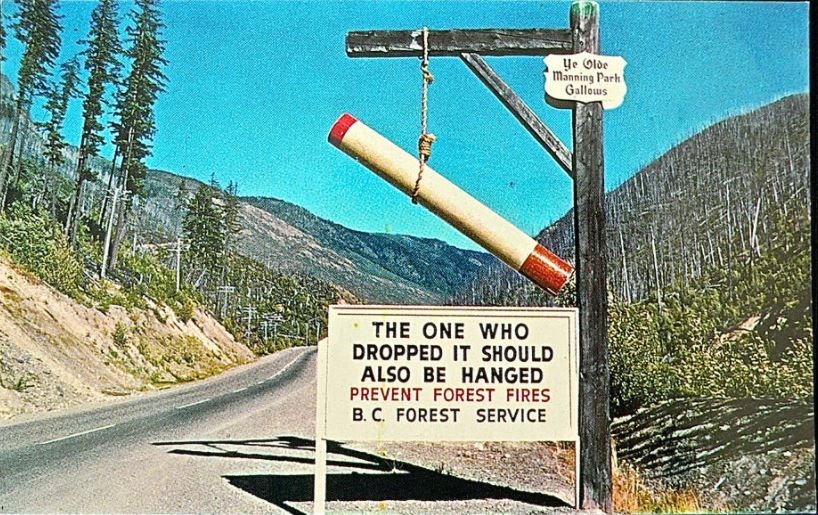
A terrible scar on a beautiful landscape, the “Big Burn” on BC Highway 3 in Manning Provincial Park, was a striking reminder of the damaging impact of forest fire for many years. Many British Columbians are familiar with the story of the 1946 forest fire and the infamous ‘Manning Park Gallows’ sign that was erected afterwards. What is less well known is how the former Department of Highways undertook an aggressive tree planting program to reforest the burnt-out avalanche start zones in the late 1970’s.
Our Avalanche Program was created in the mid-70s to ensure that avalanche paths with the potential to impact BC highways were monitored and controlled. Following the avalanche tragedy that claimed seven lives at the North Route Café on Highway 16 west of Terrace in January 1974, an Avalanche Task Force submitted a report recommending the use reforestation as a permanent avalanche control measure.
How Reforestation in an Avalanche Zone Works
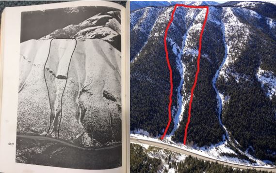
Forest cover in the starting zone of an avalanche path acts in the same way as retaining barriers in preventing snow from sliding (watch how that works in this video). It also prevents snow from drifting, a major factor in the formation of large avalanches. In many instances, the origin of the avalanche problem has been the loss of forest cover. In most cases, including Allison Pass, the cause of the loss was fire.
On the ground reconnaissance to find severe sites, similar to those of the avalanche starting zones, along roads took place during the fall of 1977. One year later, preliminary field trials of seedling test stock started at two sites in Manning Park, with 1,977 seedlings planted. Over the next three years, spring and fall plantings in the start zones of highways avalanche paths put over 40,000 seedlings in the ground, including 11,799 trees in the Burn North paths from April to May 1981.
Results of Reforestation = Success!
In the Avalanche Task Force report, Allison Pass was rated as a moderate avalanche hazard area (index rating between 10-100), noting “the highest avalanche hazard exists in the Burn.” Thanks to reforestation (including 164,000 seedlings planted on lower slopes between 1953 and 1960), the frequency in all categories has been zero for several years now, with the last notable avalanche in 2009, and the last avalanche to affect the road in 1996.
Did You Know?
There are over 1,400 avalanche paths that have the potential to affect the Provincial Highway Network. The mandate of the Avalanche and Weather Program is to ensure safety to highway users, while minimizing interruptions to traffic. This is primarily accomplished through ongoing evaluation and forecasting of avalanche conditions and the application of specific operational procedures that provide appropriate avalanche safety measures for highway users.
Find out more about our Avalanche and Weather Program in these related blogs:
> Behind the Scenes: Hanging from a Rock Face for Avalanche Safety
> Ka-BOOM! 3 Types of Remote Avalanche Control in BC
> Watching the Weather to Help Improve Safety on BC Highways
> Bear Pass and Beyond: Watch Avalanche Crews Control Snow Flow
Do you have any questions about this, or any other work we do at the BC Ministry of Transportation and Infrastructure? Let us know in the comments below.
How can we prevent FOREST FIRE when the desiders are using
D E W to light up the bush, in their opinion fire carbon will rise and block out the sun’s rays thereby cooling the earth.
Do YOU know what D E W stands for??? This is Direct Energy Weapon!!!
Suspected use was at. Lytton BC.
A car was completely consumed and a tree a very short distance way was left completly sound.
Hi F Harder – thanks for sharing your opinion with us here.
Hi TranBC,
Who (or what) owns the copyright for road signs used on provincial highways? Do they meet the criteria to be considered not at the threshold of originality?
Thank you
Hi Margie,
Thanks for the question. We follow the Canadian Manual of Standard Traffic Signs & Pavement Markings for our signage so there is consistency. It’s best not to be original in traditional road signage because drivers need to understand what they immediately mean when travelling, including those visiting us from other countries. It’s better for safety that way.
As to your questions/comments, I need a bit of clarity (and my apologies as I’m trying to reach them in the order you posted them). You concern is the arrows at Exits 10, 11 and 13 on Highway 91 are hard to read?
My comment was adding onto Marco’s comment on the gore areas being indistinguishable from normal lanes and creating a confusing situation.
The painted gore areas at the those three exits are faded out due to weather-wear (except for the ones from Cliveden Ave. on the side leading to the Alex Fraser Bridge.
Feel free to look through them on Google Maps because it wouldn’t be practical to explain them all individually. It applies to all on and off ramps at those exits I mentioned in my previous comment. That includes the on-ramp from Highway 91A to Hwy 91 west too.
Thank you once again!
Hello Margie – thanks for this. We have shared your comment with our staff in the area and will let you know what we hear back.
Is ridiculous that there is not a email, to communicate, and show pictures
Hi there John,
How can we help? Would you like to send an email regarding something? Just let us know and we will get it for you.
In Alex Fraser bridge exit 11, the division of the split roads, should be painted with solid paint, I saw somebody at night driving in the middle of the triangle by mistake, he end up almost. Hitting the sign, He’s got confused with the lanes and line markings on the road , at night.
Thanks for your comment, Marco. We’ve shared your concern forward to our local area staff and will let you know what we hear back.
I’d like to add that this problem applies to both Exit 11 going in both directions from Highway 91.
Sorry for another reply.
Looking at Google Maps this issue where the gore arrows fade exists at all on and off-ramps at Exits 13, 11 and 10. The two Cliveden on ramps and the Cliveden off-ramp leading to and from the Alex Fraser Bridge are good since the barrier transfer system came about.
There are also 130 or so avalanche paths on the Federal Section of the Trans-Canada Highway in Glacier National Park plus some in Mt Revelstoke National Park and Yoho National Park.
Thanks Nick!