We’re giving Fraser Valley drivers a helpful heads up to avoid collisions with BC’s first congestion-based Variable Speed Limit System (VSLS) on Highway 1 between Abbotsford and Chilliwack.
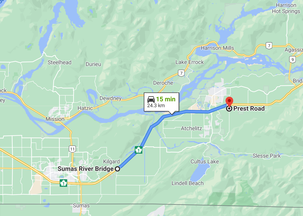
The system lowers the speed limit to slow people down before they reach stop-and-go traffic, helping to reduce the number of collisions that can happen when drivers don’t notice vehicles are stopped on the highway ahead. The system, which also adjusts speed limits based on road and weather conditions, covers a 24-kilometre stretch of the Trans-Canada Highway between the Sumas River Bridge in Abbotsford and the Prest Road overpass in Chilliwack.
We chose this section of highway because it’s heavily travelled and has a high number of collisions. Traffic on the Highway 1 corridor has grown steadily over the past six years, from an average of 45,500 vehicles per day in 2013, to 54,000 counted in 2019 (as counted just west of Vedder Road in Chilliwack).
What Travellers See
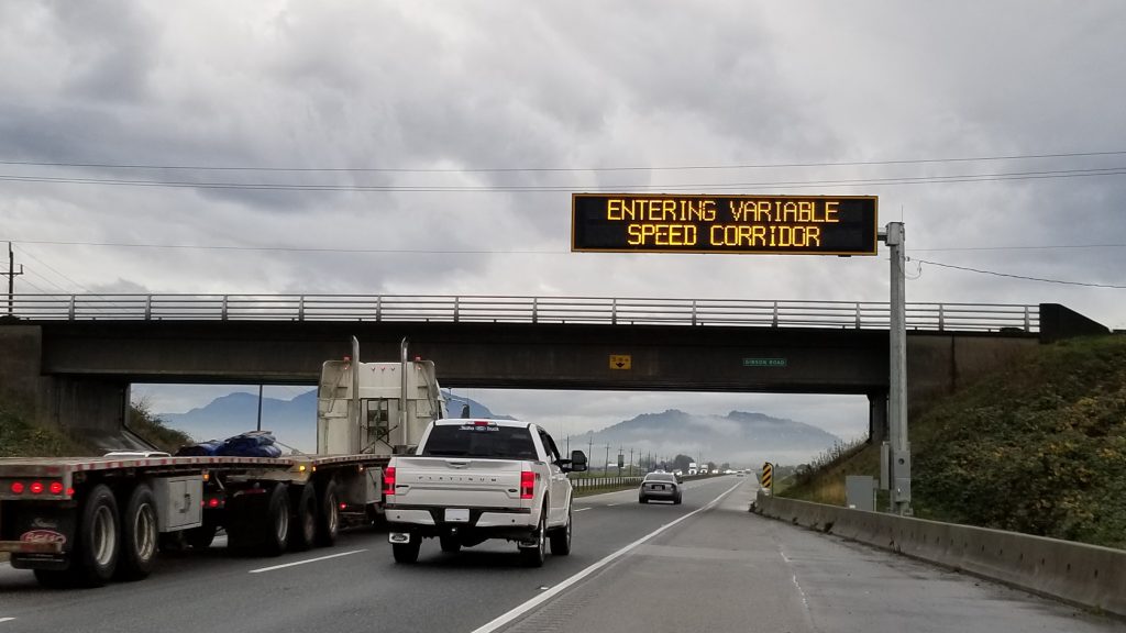
The Highway 1 Fraser Valley corridor has two “gateway” Dynamic Messaging Signs (DMS), one for each direction of travel on the corridor. Together with static signs, these gateway DMS advise drivers they are entering a variable speed limit corridor. If a reduced speed limit is in effect along the corridor, gateway DMS can also post road-weather or traffic related information.
There are 23 variable speed limit segments along the corridor. Segments are spaced roughly every 2 km, depending on local site conditions. Each segment has two variable speed limit signs (one shoulder-mount and one overhead). Fourteen of these segments also have DMS to provide more information to drivers – info such as road-weather or traffic related messages describing why a reduced speed limit may be in place.
How Speed Limits are Set
There are multiple traffic and road-weather sensors installed along the corridor. Traffic sensors are installed approximately every 500 m to collect traffic data; meanwhile, multiple road-weather sensors measure driving conditions such as level of grip, visibility, temperature, and surface status. All this data feeds into the system’s algorithms, which then propose a speed limit.
An added feature of the Highway 1 Fraser Valley corridor is the speed smoothing function. Due to the closer spacing of variable speed limit signs along this corridor, the speed smoothing function helps to ensure differences between speed limits on adjacent signs are within acceptable limits (i.e. not drastically different).
Our engineers will continue to monitor the system and adjust the algorithms that govern the system as needed.
Part of a Whole—Previous Variable Speed Limit Systems
The congestion-based system on Highway 1 is the last phase of a two-part project that began in 2019 with the installation of a road-weather system on Highway 3 between Hope and the Highway 3/5 junction (four signs).
Before that, three road-weather systems were in operation:
- Highway 1 from Perry River to Revelstoke (18 signs)
- Coquihalla from Portia Interchange to the former Toll Plaza (13 signs)
- Sea to Sky from Squamish to Function Junction, Whistler (16 signs)
If you want to learn more about these variable speed limit systems, how we collect road and weather data, or how we set speed limits in general, explore the following blogs:
>> Know When to Slow for Weather with Variable Speed Signs
>> Watching the Weather to Help Improve Safety on BC Highways
>> How Speed Limits are Set in BC: The Ultimate Guide
And, of course, you can always preview road and traffic conditions 24/7 via DriveBC.
Does google map consider reduced speed limits here?
Hi there Kaebz – Google maps does integrate bluetooth data from cars travelling in the area – although we can’t say how quickly the data is integrated. Hope this information is helpful.
Who’s responsible for the chunk of snow falling off one of these new towers that took out my windshield today at 11:10 am heading east on hwy 1.
Hello Lance,
Thank you for bringing this to our attention. This is the first we have heard of the issue and we have shared it forward with our staff for their review. Claimants are responsible for taking steps to address their own damages, so please consider going through your own insurer to allow for repairs to be done immediately. Your insurer can then follow up on the claim on your behalf, and can include your deductible into the claim total. Here is more information on the claims process: https://www2.gov.bc.ca/gov/content/transportation/driving-and-cycling/licensing-and-insurance/highway-claims
Speed limits are a safety measure but, in the South Okanagan, tossing them around like salad makes for a wonderful revenue driver.
Four (4) different speed zones on hwy 97 between Kelowna and Winfield keeps it confusing and provides plenty of ticket opportunities. There’s also hwy 33 to Big White – 50KMH on the 4-lane divided section at Black Mountain vs 60KMH on Glenmore Rd NB. Speaking of Glenmore Rd, it’s 50KMH on the SB side, with a school zone thrown in for extra fun.
In the South Okanagan, keeping drivers off-balance $eem$ ¢entral to the $afety $trategy.
Hello Bill,
Thank you for your comment. We’re sorry to hear your frustration. We have sent your message to our staff in the area and will let you know what we hear back. Stay tuned.
Nice to see the Variable Speed Limit System expanded. I think a Variable Speed Limit System would be great on the Malahat highway to provide a lower statutory speed limit when the weather conditions deteriorate. Has the ministry considered installing a Variable Speed Limit System on the Malahat? Thank you!
Thanks for your feedback, Colton. We will share your suggestion forward.