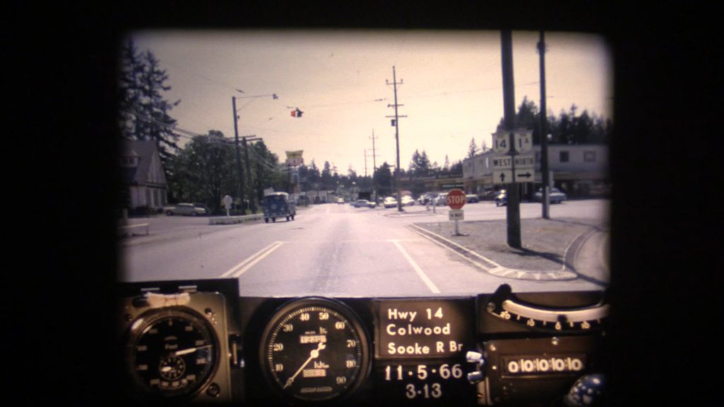
Get in and buckle up! Our beloved BC Road Trip Time Machine is back in action. This time we set our “flux capacitor” to Highway 14 (also known as West Coast Road) during the spring of 1966. Highway 14 is the southernmost numbered route in the province, stretching from Langford to Port Renfrew on the southern tip of Vancouver Island. It’s a long and windy road so, pull up a chair and get ready to take a trip down memory lane.
This footage captures the highway as it was on May 11, 1966 between Colwood and Jordan River. It wasn’t until 1975 that the route was officially extended to Port Renfrew. Another interesting note – while the highway started in Colwood in 1966 (at what is commonly called Colwood Corners), it now officially begins at the intersection of Veterans Memorial Parkway in Langford, which opened in 2002. Many long-time locals will recognize old alignments, buildings, signs and vistas but we’ve collected a short list of some of the more significant highway improvements along this route in recent years. Let us know in the comments below if you notice more!
- West Shore Parkway connection
- Sombrio Beach Bridge replacements and new rest area
- Shoulder improvements, safety signage and line marking throughout
- Sooke River Road intersection upgrades
- Galloping Goose crosswalk enhancement (Sooke)
- Sooke roundabout
- Jacklin Rd. bus queue-jump
- Muir Creek slow vehicle pull-out
- Widening and paving (scheduled to begin spring 2020)
Where did these videos come from?
We captured these nostalgic videos (or photologs) digitally from 16mm film reels taken in 1966. The original photologs were collected by rigging a camera apparatus onto the dash of a van that took still images about every 80 feet. These images were combined into a single film for each route. As far as we know, the “Highways Department” (as it was then known) was the first organization in Canada to collect information this way in order to create a visual record of road condition information from across the province, thereby allowing our engineers to study a stretch of road without having to travel there. Pretty cool, eh?
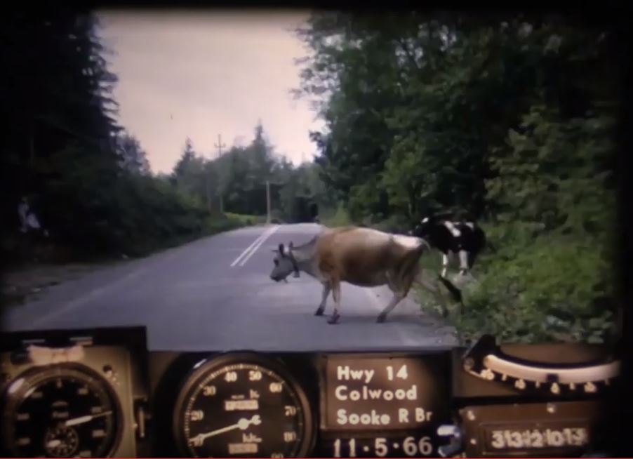
Looking back on these old reels reveals a lot more than just pavement condition. The camera driven through more than 9,000 km of BC highways captured some incredible glimpses of our province during the heyday that was the 60s.
If you’ve been riding along with us, you’ll know we’ve toured many other parts of the province in our BC Road Trip Time Machine travels. Looking for a particular stretch of BC highway in this series? Let us know in the comments below and stay tuned for more episodes as we work our way through the rest of the 1966 photolog footage. We also have a collection of still images taken from each video on our Flickr site so, check them out!
Or, if you liked this blog, check out some of our other, awesome historical content:
- BC Road Trip Time Machine: Travel Back to Highway 14 in 1966
- A BC Highways Perspective of the Hope Slide
- BC Road Trip Time Machine: See Vancouver as it was in 1966
- See the Construction of the Fraser Canyon Highway in Historical Photos
- Snapshots in Time: Who is the “Highways Department”?
Do you have any questions about this, or any of the other work we do? Let us know in the comments below. We’d also love to hear about what you see (or don’t see) in the video.
I quite enjoyed that; I didn’t get lost once. I saw our family B/A gas station at Glen Lake corner flash by, as well as the store that burned down at the corner of Gillespie and Sooke, near the 17 Mile House.
Wow! What a special connection. We are so happy to hear this, Doug. Thanks for sharing and safe travels.
way too fast but still brought back so many happy memories and even an allergic reaction to all the broom – miss the Island. thanks for this
Amazing film. That year, I drove a dump truck on Hwy 14 hundreds of times to earn money for college. Each time a truck appeared on the video I looked to see if it was me 56 years ago.
How cool is that!? We did have a comment on our Sea to Sky time machine from a girl who spied her dad driving a logging truck across the road. We are so thrilled that so many people are watching these and connecting with them. Safe travels.
This was very nice to watch! It’s definitely very interesting to see some parts of the roads have changed significantly while others haven’t changed much. I would love to see archived footage of Highway 1 between Goldstream Park and Victoria. Also, Highway 99 (Hwy 499 at the time) between Richmond and the US Border would be interesting to see.
Thanks for the kind words Colton. We love these old reels too. We did capture the Malahat section of the highway during 1966 and you can watch the footage here: https://www.youtube.com/watch?v=IV1-ElUMkDU&list=PLKHNpQ_j-IWG8CG_KN7cwl5mMO2bz2x8w&index=15
Unfortunately, due to heavy use of the reel, the first few feet of film were lost, with the drive picking up near the flats and heading up the mountain from there.
We will make a note of your request for footage of the 99 (yes, 499 at the time). Safe travels!
Video running too fast, not enjoyable 😭😩
We’re sorry to hear that Vera. Yes, these videos were actually captured at an even higher speed than this. We slow them down to approximately 25 per cent of their original speed in order to see things in more detail. If you are viewing these on YouTube directly, you can choose the icon gear in the lower right hand side on the screen and further reduce the speed. Hope that this helps!
Hi, was there any footage taken of old highway 6 from Nakusp to Burton, BC? Thank You!
We will put it on the list Leanne!
That was wonderful. The way it was, slow moo-ving traffic and all. Thanks!
Glad you liked it Jeff!
I appreciate these trips and do enjoy them. Not to often you see dairy cows on a highway.
Thanks Rory! So good to hear. Probably a good thing we don’t see cows moo-ving around on highways so much these days. Sorry, couldn’t resist.