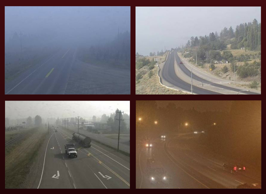
As witnessed in recent years, wildfire season in BC can happen on a massive scale; cloaking the province with a gloomy shroud of smoke, making the air pungent and thick, and giving the sun an eerie blood orange tinge.
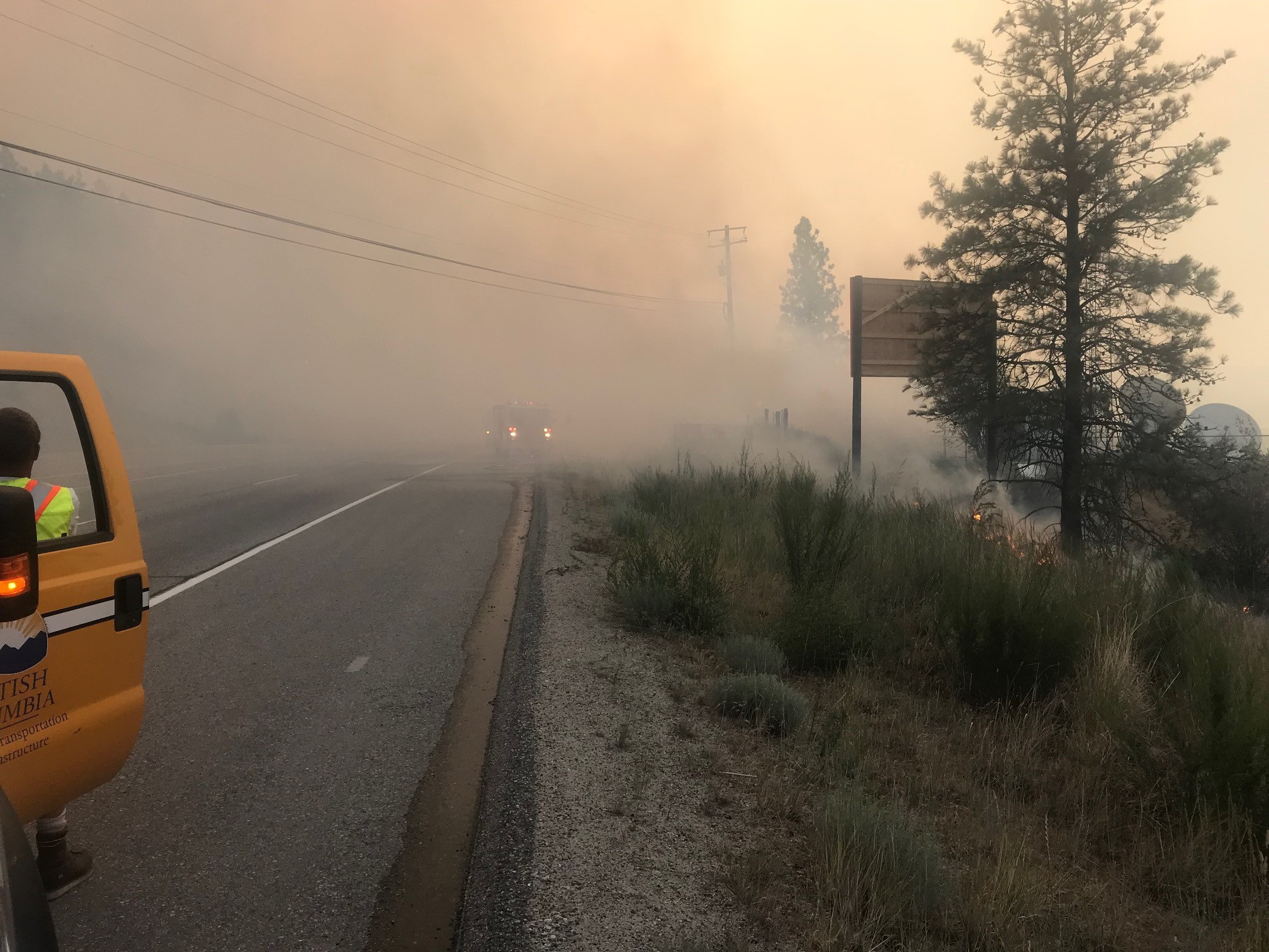
Wildfires can come precariously close to side roads and highways; sometimes roads are closed or with limited access, even more have very poor visibility.
That’s where we come in.
We want to share a few tips and resources to help you travel safely during wildfire season.
Down to brass tacks: Where can I travel?
>> BC wildfire impacts to highways, including closures and traffic restrictions, are available via DriveBC.
>> When wildfire impacts to highways and side roads reach a certain level, they are listed on our Current Road Advisories and Information page.
>> Impacts to forest service roads are here.
Smoky haze for days: Driving with poor visibility
Usually, it’s the wet, dreary winter months that make visibility challenging. But forest fires can create a summer “fog” that can dim the lights in a unique way. Sometimes day looks like night, other times it seems like we’re looking at the world through an Instagram filter.
Please remember these tips for seeing and being seen:
>> Turn on your headlights and tail lights. Ideally, we do this every time we’re behind the wheel, but it’s even more important in dark, hazy conditions. Don’t rely on the automatic headlights feature. Keep it simple, turn ‘em on.
>> Keep your eyes on the road, and avoid distractions. Again, this always applies, but the smoke is dramatically reducing stopping sight distances on the roads, reducing drivers’ reaction times.
>> Don’t gamble by passing on two-lane, two-way highways when long-range visibility is reduced. Wait for a truck climbing lane or other multilane section to pass.
>> Slow down. Remember: posted speed limits are for ideal conditions. A smoke screen is not ideal conditions.
>> Give more space to the vehicle ahead of you. Bad visibility can lead to abrupt stopping as reaction times are reduced. And let’s face it, no one likes a tailgater.
>> Top up your wiper fluid. That white stuff falling from the sky? Yeah, those are ashes, not snowflakes. Don’t let a dirty windshield make your view of the road worse.
>> If you have to pull over for any reason, make sure you are completely off the road with hazard lights flashing.
>> Only drive if you feel well enough to do so. Forest fire smoke is a mix of gases and small particles that can irritate the respiratory system, and the poor air quality is affecting some people’s health more than others. If you feel exhausted, dizzy, or impacted in any way that could reduce your ability to drive, best not to get behind the wheel. Here’s more information from the BC Centre for Disease Control about how to protect yourself from poor air quality.
Extreme weather events, such as wildfires, may be the “new normal” in a world undergoing significant climate change, but life goes on, which means goods are still flowing and people continue to travel. Let this be clear: safety is our biggest concern. Closures will continue on highways and roads deemed too hazardous for travel. It’s important to keep informed about road conditions, closures and restrictions, and adapt our driving behaviour to stay safe despite the smoke.
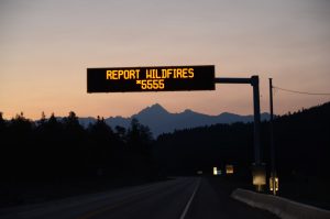
If you spot a wildfire, please report it to the BC Wildfire Service at *5555 (a map of active wildfires is available).
There is also a free BC Wildfire Service Public Mobile App you can use, if you have data or a WiFi connection. Select the “Report a Fire” function to submit an electronic report and upload a photo — a video tutorial in the “Help” section explains how. The app also offers real-time wildfire information and an interactive map that can be customize to display a variety of fire-related data. For Android, the BC Wildfire Service mobile app can be downloaded at Google Play. If you have an Apple (iOS) device, you’ll find it here, at the App Store.
Residents of areas impacted directly by wildfires can view a list of community and regional district evacuation orders, alerts and rescinds at EmergencyInfoBC.
Do you have any wildfire season travelling tips worth sharing? Please do – there’s a comment section below.
Squmash to Canmore, is the fire affecting this? Thanks,
Hi Pat. The wildfire situation in BC remains very dynamic. We would encourage you to check DriveBC.ca for up-to-date information and our Travel Advisory page here as well to plan your route.
Safe travels.
Hi. My daughter, son in law and two grandkids are visiting Canada from the UK right now and will be in Sun Peaks on Friday 25th August. Travelling in from Alberta. They will be there for 2 days, if this is still possible, before driving to Vancouver prior to departing for the UK. They have a rental car that needs to be dropped off at YVR. Can you offer any advise on the best route for them to take from Sun Peaks to Vancouver avoiding the fires.
Hello James.
The wildfire situation in BC remains very dynamic. We would encourage you and your family to check DriveBC.ca for up-to-date information on road closures and incidents and our Travel Advisory page here as well to plan your route. Other good resources and information are also available at EmergencyInfoBC.ca.
Travel prepared with extra supplies and follow all travel restrictions.
Wishing you and your family safe travels.
We are supposed to attend a wedding in Kelowna on Aug 25. Essential travel information lists funerals and courses as essential, but doesn’t mention weddings. Do weddings fall under the essential travel exception?
Hello Anna Marie.
Weddings have not been identified as essential travel at this time. We need roadways to remain clear for emergency response operations. We encourage you to check Emergency Info BC for the latest info.
Thanks for connecting with us.
We would like to know which route is the safest route to get to Vancouver from Oliver. We have been looking at DriveBC and it is not clear which route should be used.
Hello Louise. We would recommend using DriveBC’s “Plan your route” function here: https://www.drivebc.ca/directions.html The Wildfire situation in BC remains dynamic and we advise you to continue to check DriveBC.ca and Emergency Info BC at https://www.emergencyinfobc.gov.bc.ca/ as the situation continues to develop.
We have a loop through BC and Alberta leaving Anacortes on August 19. Our route is up Hwy 1 to Hwy 99, stopping in Whistler for a 2 day stay. Then headed north to Prince George via 97N (4 days).
On 8/25 we head to Jasper, then south through Lake Louise, Vernon and the Okanogan valley to return to eastern Washington. I am concerned with visibility while driving as well as pending evacuations. Are there current road closures due to wildfires in this area? Or with the anticipated path of the fires?
Hi Lisa, thank you for reaching out to us here. Please check DriveBC.ca’s Conditions & Events tool for up to date information on your route. We also advise that you stay tuned to BC Wildfire Service’s wildfire map to track the situation along your route — which currently has several active wildfires; and also to EmergencyInfoBC for verified emergency info as the situation is currently very dynamic. Thanks again, and travel safe!
We need to drive from Cranbrook to Golden on 95/93. What are the roads like with the St. Marys fire? For 7/25/2023
Hi Jim, thanks for connecting with us here. Please check DriveBC.ca’s Conditions & Events tool for up to date information on your routes: https://www.drivebc.ca/#listView&road=Highway%2095%7CHighway%2093
We are seeing single-lane alternating traffic in effect on both HWY93 and 95, and warnings of limited visibility due to wildfire smoke.
We are leaving Edmonton to kelowna. Wednesday morning. We go through Kamloops , is the highway closed due to wildfires? What would be the best route to go?
Hi Sheila – thanks for reaching out to us here. As wildfires are dynamic, it can be hard to predict how or when they may impact highway travel. We encourage you to check our 24/7 traveller information site – DriveBC.ca for more information on any events impacting travel on your chosen route. We hope this is helpful. Safe travels.
Hi Sheila, thanks for connecting with us here. We are not seeing closures along the route (HWY1 -> HWY97), but given the wildfires please be prepared for a dynamic situation. We encourage you to use DriveBC.ca’s map view and conditions & events tools to stay up to date on current conditions and closures
We need to drive from Crawford Bay on the Eastshore of Kootenay Lake to Maple Ridge BC … leaving Saturday morning. What looks like the best route?
Hi Mary, thanks for reaching out to us here. While Highway 3 would be your most direct route, there are some delays expected along the route for road maintenance work. In wildfire season it is hard for us to offer advice as the situation is very dynamic – we advise you check DriveBC.ca for up to date information on road closures (planned and emergency related), and also to check EmergencyInfoBC for verified event information on emergencies.
What is the situation between Hope and Chilliwack? We are leaving Thursday morning from Peachland to catch a ferry to Gibsons on Thursday evening. Will highway 7 be open or closed?
Hello Gordon – thanks for taking the time to reach out to us here.
As wildfires are dynamic and unpredictable, we are unable to say what the situation will be on Thursday.
We encourage you to check DriveBC.ca for the most up to date information on closures or impacts to travel, before you leave and during your travels (when safe to do so).
At this time, Highway 1 is open (although reduced to one lane eastbound between Chilliwack and Hope) and Highway 7 is not impacted by wildfire. As mentioned above, this could change at any time, and DriveBC remains your best source of information.
Sept 11
What roads are closed due to wildfires.
And how long are they anticipated to be closed?
Hi Edna. As of now, Monday morning (Sept 12), there are closures due to wildfires on Highway 29, Highway 52, and eastbound Highway 1 (5km east of Chilliwack to Hope). Detour information and other travel updates are being posted to DriveBC: https://drivebc.ca/mobile/pub/events/majorevents.html
Since DriveBC seems to be the fallback, it would make sense if it could show recommended alternatives in response to wildfire and floods
Thanks for the comment, Robert. When a highway is closed, DriveBC includes detour information when available. Is there a specific event you are concerned about?
Request: We would like to obtain a PDF copy of your Rest Stop Map.
thank you
Hello Moira,
Thanks for your message. We have just sent a PDF copy of the Rest Area Map to the email address you provided here.
Safe travels!
I’m in Kamloops trying to get home to Vancouver island.
What would be the best route for me?
Hi Amanda – sorry for the delay. This page is only monitored during regular business hours. We hope you found your way home safely and recommend that you use the DriveBC.ca website to help you navigate and road events that might cause delays. Safe travels!
I am in Saskatchewan visiting family. I left in late July. I need to return to Chilliwack for work on August 27. Because I need to return to work is my travel essential?
Hi there Danette,
Thanks for checking with us here. We are currently only asking that folks don’t travel to the interior of the province for recreational activities. Your trip home falls outside this and is fine. Please check DriveBC.ca before you leave, in order to get the most up to date information on any issues that might impact your travel before you head out. Safe travels.
Hello, I am from out of province trying to get across BC to visit my daughter on Vancouver Island next week. I’m bringing my small travel trailer but plan to go directly to the Island and wasn’t sure if that is permitted at this time.
Hi Mike,
Thanks for checking in with us here. Travel through wildfire impacted areas is allowed. We are trying to discourage recreational travel to those areas being hard hit by wildfire at this time. Please check DriveBC.ca before your trip to get a better sense of travel advisories, closures and delays and consider using alternate routes (around the Okanagan) if possible. Hope this is helpful. Safe travels.
hi im in new westminster and wona travel to alberta edmonton my home is it save drive with my family?
Hello Ahmed – thanks for your message. DriveBC.ca is where you can go to get all the details of the closures and delays on BC Highways due to wildfire. If a highway is unsafe for travel due to wildfire, we will close the highway and post detour information there as well. Hope this is helpful. Safe travels.
What is “essential travel”? We are returning home to Penticton after a visit to the Lower Mainland. Is that essential travel?
Hi Gary,
Thanks for your message. Yes, travel home is fine. We are trying to discourage recreational travel to the interior in order to give communities and first responders the space and resources they need. Thanks for checking. Safe travels.
Good read
Thanks Terry! Safe travels.
Hi I have family returning to Alberta tomorrow travelling from Vancouver island to Grande Prairie.
Taking highway 1 from hope to Kamloops and highway 5 to Alberta boarder. Is this area safe to travel through stopping for fuel only.
Hi Ruth,
The travel conditions change regularly with the current wildfire situation. I’d recommend checking DriveBC.ca before they travel to have the latest information.
I am going to be travelling from Calgary to radium on Friday, August 20 is there any restrictions that I should be aware of
Hi Darcy, unfortunately we can’t predict the future (wish we could). But I would recommend you check DriveBC.ca for the latest travel information right before you plan leave.
Is travel to and from Kelowna still not recommended?
Due to the continual wildfire situation and the current travel advisory to “Avoid non-essential travel to and from Kelowna, West Kelowna, Peachland, Lake Country and Westbank First Nations lands (Central Okanagan Local Health Area)” due to COVID, it’s still not recommended.
Is a wedding considered “essential travel”? Have been planning for many months, keeping it small, am hoping to take Road 40 from Lillooet to Gold Bridge do you think this will be possible?
Hi Kayla,
Information on essential and non-essential can be found from Interior Health here: https://www.interiorhealth.ca/AboutUs/MediaCentre/NewsReleases/Documents/IB_COVID_Outbreak_6%20August.pdf
As to travel conditions, wildfires are changing our advisories and closures regularly. To have the current information, please check DriveBC.ca.
Hi….I’m travelling from kelowna to edmonton on the 22nd of August. Am I going to be impeaded by fires?? Which route would be the best way to go?
Hi Linda, highway conditions can change so it’s very hard to predict what it will be, especially during wildfire season. Please go to DriveBC.ca closer to your date for the latest travel information so you’re best informed.
Travelling from kelowna to lillooet to staff Emergency Department can I travel north on #5, recommendation for route given fires?
Hi Gord, DriveBC.ca is our 24/7 travel information resource. I’d recommend referring to that to best inform you before you travel.
We are planning to travel to Banff with a stop over in Salmon Arm. We are in a large motorhome. Are there any issues with travelling this route?
Hi Victora, travel conditions can change. Please check our 24/7 resource DriveBC.ca for the latest up to date travel information.
Hello
I have a trip planned to Kelowna next week. Should I cancel? I ma having a hard time finding a definitive answer to if we are allowed to travel there. We will be staying in Kelowna, not driving around.
Hi there Kerry – at this time, the Province is recommending that folks avoid non-essential travel to and from Kelowna, West Kelowna, Peachland, Lake Country and Westbank First Nations lands (Central Okanagan Local Health Area). https://www2.gov.bc.ca/gov/content/covid-19/travel/current
I’m driving to Surrey from Manitoba august 16. Will I be ok to do that? This is my first time driving through the mountains.
Hey there Rita – thanks for your message. We encourage you to visit our traveller info tool, DriveBC.ca before you leave and whenever you can safely do so during your trip, to get a better idea of what to expect on BC highways when you get here. Give yourself plenty of time to travel, so you don’t have to rush, pack water and food in your car in case you are delayed. Given the large amount of wildfire activity in the province this year, you should also expect smoky conditions during your drive and added volume on our highways due to wildfire detours. Safe travels!
I will be travelling from Vancouver to Castlegar on Tuesday, Aug 17 using highway 3. Are there any closures of highway 3 due to Garrison Lake fire and Nk’Meep Creek fire? Can I stay safely in Osoyoos?
Hello Barbara,
Thanks for connecting with us here. Unfortunately, given the dynamic and unpredictable nature of wildfire, we aren’t able to say what the wildfire conditions impacting highways will be on that date. We encourage you to check DriveBC.ca closer to your travel time, to get a sense of what the situation is and plan accordingly. We have also created a webpage listing wildfires which are impacted by wildfire here: http://www.tranbc.ca
Safe travels.
Hi there,
My daughter, partner and their 14 month old were evacuated from their Falkland home and currently staying in a hotel in Vernon. I want to travel from Langley to Vernon to go help my family. I would head through the connector and into Kelowna way. Is there any road closures and if I should be going?
Thankyou
Hello Catherine,
DriveBC.ca is your best source of information of road closures due to wildfire and we encourage you to check the site often, as the situation can change quickly. We are also listing roads closed or seriously impacted on this page: https://www.tranbc.ca/current-wildfire-advisories/
We hope that this is helpful. Safe travels!
looking to travel to red deer alberta from the lower mainland was hoping to take Hwy 5 up thru barrier , clearwater and then down to sask river crossing i dont see any closures on this route at this time will check again before leave sunday 5 am
Hi Alyson. Thanks for your message. We hope you made the journey well. Safe travels.
We are planning to do the Hot Spring Circle route in bc this week what is that area like with fires?
Hi Marilyn – thanks for your message. DriveBC and the BC Wildfire Service are your best sources of info for wildfires and any impacts to highway travel as a result of wildfire. We hope are having a safe journey!
Hi there,
We are travelling tomorrow to Invermere area and staying there for a couple of days. We understand that the smoke is an issue although there aren’t any fires in the area. Will there be closures of highway 93 into this area and will the thunder storm clear some of the smokiness in air quality?
Hello Anthony – thanks for connecting with us here. We are not sure when you are planning your travel and given the unpredictable nature of wildfires, we can’t say with any certainty what conditions you will experience on your journey in advance. We strongly suggest you continue to check DriveBC.ca as often (before you leave and as often as you can during your trip), to be in the know. Give yourself plenty of time to travel and make sure you have water, gas and food on hand in case you are stopped unexpectedly. Safe travels.
My daughter is driving from the Fraser Valley to Salmon Arm tonight after work & then carrying on to Banff in the morning. We’ve been checking Drive BC and the BC Wildfires websites but it’s hard to determine what would be a ‘smoky drive’ versus what will be an ‘unsafe drive’.
Would you say overall “it is safe for her to travel with her taking appropriate precautions & preparations” or would you say ”it is un-advisable for her to be travelling this route at this time”?
*(She will be taking hwy #1 thru Fraser Valley, then North on Coquihalla, then across to Alberta via hwy #1 again).
Hi there Nicholas – thanks for connecting with us here. Sorry for the delay in this response – this page is only monitored during regular business hours. We hope your daughter found her way safely to her destination. DriveBC.ca is your best bet for up to the minute road condition information. If a route is dangerous to travel, we will close it until it is safe to reopen or post a travel advisory outlining impacts to travel and post that event on DriveBC.ca. We hope this is helpful. Safe travels.
Hi, we are planning to drive from Kelowna to Vancouver at 6am tomorrow morning…is there any road closures en route to be mindful of?
Thank you for your feedback
Hi there Elzane – sorry for the delay in this response – this page is only monitored during regular business hours. Given the unpredictable nature of wildfires, we can’t say with any certainty what conditions you will experience on your journey in advance. We strongly suggest you continue to check DriveBC.ca as often (before you leave and as often as you can during your trip), to be in the know. Give yourself plenty of time to travel and make sure you have water, gas and food on hand in case you are stopped unexpectedly. If a road is closed due to wildfire that closure and any detour information will be posted on DriveBC. Safe travels.
What are the rules for travelling into an area under Evaculation Alert please?
Hello Pat,
Any area which is under evacuation alert needs to be prepared to leave at a moments notice under an evacuation order. As such, it is strongly recommended that you do not travel into an area under an evacuation alert. We hope that this is helpful. Safe travels.
Hi ,We are plan travel to Vancouver & Vancouver island in this Wednesday 28th true Vernon . so is there any road closure?
Hello and thank you for your comment. Given the unpredictable nature of wildfires – we are unable to predict if and how they will be impacting your travel on Wednesday. We have created a wildfire advisory page – listing highways impacted by wildfire and at this time, Highway 97A, south of Sicamous is CLOSED between 5 km north of Enderby to Sicamous. You might want to plan your route around this closure.
Please note this page is not updated 24/7 and you should refer to DriveBC.ca for up to the minute information on any conditions which might impact your travels. DriveBC.ca is the authority on current closures. We hope that this is helpful. Safe travels.
What are the driving rules if the highway you need to drive on runs through an area that is now on alert?
I am looking at driving from lower mainland to Penticton….
Good afternoon Cindy,
Our staff in wildfire impacted areas are working closely with emergency crews. If a wildfire threatens highway travel, or if it is deemed unsafe in any way for travellers to move through the area, our staff will close the highway and that closure will be posted on DriveBC. We encourage you to check DriveBC for the most up to date information. We hope that this is helpful. Safe travels.
Hi we r in revelstoke n going back to airdrie…is it safe to go through highway 1 or is there any road closure…..I have two little kids
Hi there Preet – thanks for your question. DriveBC.ca is the best source of incident and closure information for BC highways. At this moment (8:34 am on Friday, July 23) there are no closures on BC highway 1 due to wildfire. Please note that there is construction east of Golden at Kicking Horse Canyon which might cause delays. We hope this is helpful.
https://www.drivebc.ca/#listView
Travelling from Banff to Radium Hot Springs along hwy 93 — is this area ok to travel through?
Hi Joyce – thanks for your comment. DriveBC.ca is our traveller information system and the best source of information on closures and events. At this time we can’t see any closures due to wildfire on Highway 93 or Highway 1 but given the dynamic nature of wildfire – this could change at any time and we encourage you to check DriveBC as often as possible.
https://www.drivebc.ca/#listView
Please note there is construction underway with intermittent closures on Highway 1 east of Golden at Kicking Horse Canyon which might cause some delay.
Safe travels!
Safe travels.
Planning a trip from Cranbrook to Vancouver tomorrow July 22 Need to catch the 6:00 pm ferry to Victoria. Will there be delays due to wild fires?
Hi Bob,
At this time Highway 3 looks clear however you should expect increased traffic on all BC highways due to detours from wildfires. Give yourself plenty of travel time and be prepared for delays. Wildfires are unpredictable and the situation could change rapidly. Check DriveBC.ca (use the plan your route feature) to get a sense of what is happening on your planned route before you go and try to check DriveBC as often as you can during your trip. Safe travels.
I am traveling down south from Prince George to Vancouver, leaving at around 5pm, that should bring me to Lytonn and 100 mile areas at around 11pm ish. Am i safe to travel through with my little toddler and wife expecting.
Hello Frank – thanks for reaching out here.
At this time, Highway 1 is CLOSED between Hope and Spences Bridge to support firefighting operations. Detour via Highway 5 (Coquihalla).
DriveBC is also reporting the following conditions for Highway 97 around 100 Mile House:
Travel advisory in effect between Big Bar Rd and 94 Mile Frtg for 54.2 km (5 km south of 100 Mile House to 7 km north of Clinton). Limited visibility with smoke due to a wildfire. Road is open to traffic. Future closures possible with very limited notice. Watch for smoke, Drive to conditions Speed 80km advised.
DriveBC.ca is your best bet for up to the moment information and we encourage you to check it wherever possible during your trip.
We hope that this is helpful. Safe travels.
Hello again Frank – looks like Highway 97 was closed overnight due to wildfire. We hope you found your way through or around this area in your travels last night. Safe travels.
driving from Grande Prairie to Richmond BC on july 28th. Quite nervous about the possible closures as i will not have an internet connection to check for updates,just my gps. i suppose stopping at every town hoping for wifi is my best bet!
Hi Anj – checking your planned route via DriveBC.ca before you leave and as often as possible is your best bet. Any major routes with closures or detours in place will also have messaging via our overhead message boards, roadside message boards. We’ve also created an emergency advisory page for areas with roads impacted by wildfire here: https://www.tranbc.ca/current-wildfire-advisories/
Don’t forget to pack extra food and water in case you are delayed. Safe travels!
Evacuating a family on Monday to the Lower Mainland. Already watching the no so up to date fire map. What fires of concern along hwy 5 south from Blue River to Hope? Can we expect clear sailing in both directions in light of our errand of mercy?
Thanks.
Hi there Firesmart Rep – thanks for connecting with us here. Any wildfire impacting travel on BC highways will be posted on DriveBC (and communicated out via @DriveBC, @TranBC).
If you don’t see anything on DriveBC you should be good to go. As fire situations can develop and change course quickly, we encourage you to check the site regularly during your travels, if possible. If you have any concerns about a specific area – we encourage you to reach out to the local emergency authority to ask for clarification. Here’s a link to those:
https://www.cariboord.ca/en/index.aspx
https://www.tnrd.ca/
https://www.rdek.bc.ca/departments/protectiveservices/emergencyinfo/
https://emergency.rdos.bc.ca/
http://www.rdno.ca/
Thank you for the up to date info and tips. Traveling this Friday on the following route: Tok, Alaska- whitehorse – Watson lake – fort Nelson – grand prairie – Airdrie – Great Falls Montana. Not seeing any closures on that route at the moment, anything I am missing?
Hi Joe,
Thanks for checking in with us. No, you’re right there are no closures at this time on the Alaska Highway/(BC Hwy 97) in BC. (I can’t speak for Alaska, Yukon, Alberta or Montana).
During wildfire season, things can change quickly so please check DriveBC.ca http://www.drivebc.ca/mobile/ to know before you go, and during breaks along the way, while in British Columbia.
For the other jurisdictions:
Alaska: http://511.alaska.gov/alaska511/mappingcomponent/index
Yukon: http://www.511yukon.ca/en/
Alberta: https://511.alberta.ca/
Montana: http://roadreport.mdt.mt.gov/travinfomobile/
Rule of thumb is if there are no conditions on the map or reported on the list, then there is nothing you need to be aware of. (eg. closures, incidents etc.)
Safe journey!
I am going through British Columbia from Alaska…to Dawson Creek and then down 97 through Prince George and continuing to the US border. I have two dogs who have their papers good until August 30… I leave Skagway on August 25. First is the road open and second do I need to anticipate delays
Hi Jill,
Highway 97 near the Alaska border is open to single lane alternating traffic due to wildfire at this time. The rest of your proposed route, 97 through PG to Kamloops is affected by poor visibility but is not currently closed due to wildfire. We suggest you use the “Plan Your Route” function on DriveBC.ca: http://www.drivebc.ca/directions.html This will show all the conditions, incidents, events, etc, along your way. You can also use the map to change your route, so you can see what the conditions are on alternate routes, should conditions change. Our latest blog gives you tips on driving during the wildfires in BC: https://www.tranbc.ca/2018/08/21/what-you-need-to-know-about-travelling-during-bc-wildfires/
are any railway lines affected by the fires and smoke?
Hi Paula,
Unfortunately, we can’t confirm which, if any railway lines are impacted by the current wildfire situation in BC. Please connect with the railway line directly for more information on this. Thanks and safe travels!
ok thanks. great website!
Thanks! We love hearing that. 🙂