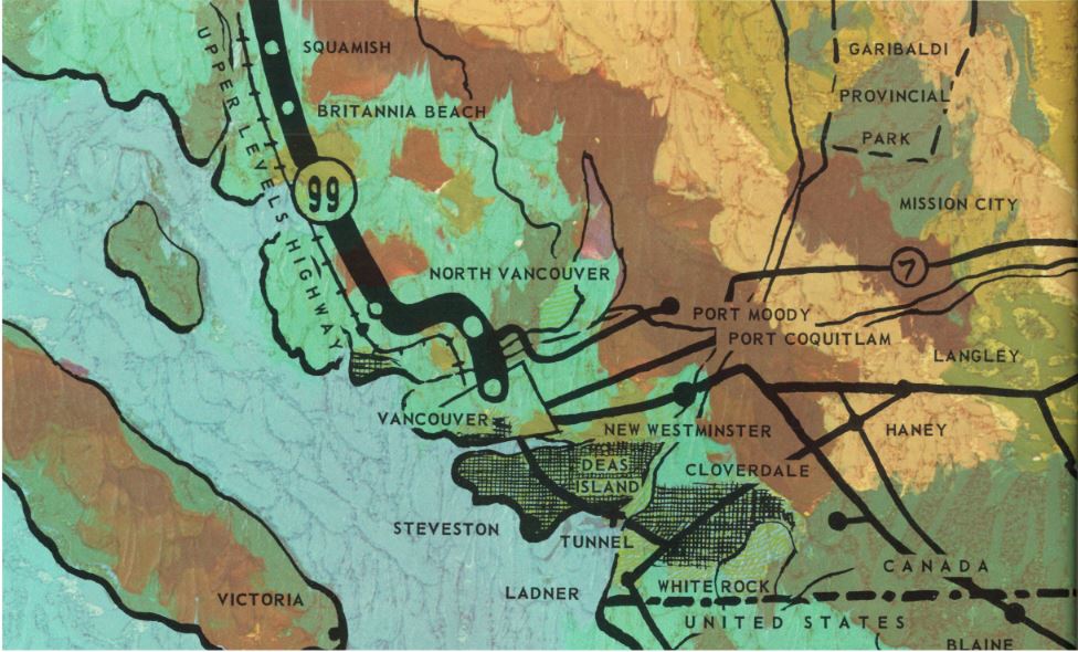
Get in and buckle up because this episode of our BC Road Trip Time Machine is set to take you on one curvy highway – Highway 99 from Horseshoe Bay to Squamish to be exact.
The “Sea to Sky” corridor is undoubtedly one of the most beautiful drives in the world, taking motorists on a dramatic route from Vancouver along the Howe Sound, through Squamish, then on to Whistler and beyond. Many improvements have been made to this highway over the years, most significantly those completed in 2010 but, in 1966, the highway was a single lane of traffic in each direction, carved into the dramatic cliffs of the Coast Mountains where they met the sea. Spoiler Alert: In 1966, there was no paved provincial highway connecting Squamish and Whistler (then Alta Lake). Our photolog for this route ends after Squamish, where a narrow gravel road continues on.
What’s a photolog?
We recorded these nostalgic videos (or photologs) from 16mm film footage taken in 1966. The original photologs were collected by rigging a camera onto the dash of a car that took still images every 80 feet or so and then running them all together as a single film. As far as we know, the “Highways Department” (as it was then known) was the first organization in Canada to collect information this way in order to create a visual record of road condition information from across the province, thereby allowing our engineers to study a stretch of road without having to travel there. Pretty cool, eh?
Where have we been so far in the time machine?
If you’ve been riding along with us, you may have already toured the southern stretch of BC Highway 97, from the U.S. Border to Vernon, as well as the northern portion of 97 between Prince George to Dawson Creek as it was in 1966. We have also driven over Vancouver Island’s Malahat Highway and along Highway 1 and the original Port Mann Bridge in our BC Road Trip Time Machine travels.
Stay tuned for more episodes in your special corner of the province as we work our way through the rest of the 1966 photolog footage, and don’t forget to check out our Flickr set of still images taken from this and other reels in our Flickr set.
If you found this article interesting, you might want to check out these related links:
This is sooo cool! Can’t wait to check out the other routes –
Yay! We are glad to hear you think so, Trish. Here’s a link to the full playlist: https://www.youtube.com/playlist?list=PLKHNpQ_j-IWG8CG_KN7cwl5mMO2bz2x8w
Used to live in Creekside there was no road
You should do Prince Rupert to Terrace
On the list Harry – stay tuned!
Talk about going back in time. I have imagined in my mind travelling on this Hwy many times. This really brought it back to life. It was so often an adventure no matter which way you went, between washed out bridges, rock slides and unfortunately…accidents. This was just before we moved back to the beach. In “67 our house was buried by a mudslide along with Brazeau’s house. It would be great to see footage of the hwy from Squamish to Whistler, anyone remember deadmans corner.
Hello Dave,
Thanks for connecting with us here and sharing your memories! While there may have been a road between Squamish and Whistler in 1966, it wasn’t part of our official highway system and not captured in our photo log footage. It might have been captured in later years though so stay tuned.
We drove this road many times, winding our way across the Daisy lake dam and beyond to get to Whistler to ski the very first year it opened. Wild rides through the canyon during snowstorms and freezing rain. Slides at Porteau Cove and many other places. Creeks washing out bridges once in a while. Great days. But I thought we ran out of pavement at Britiannia Beach, not at Squamish in those early days.
When we lived in Britannia, there was no road – just the Union Steamships, to carry people from Vancouver to Woodfibre, Squamish and Britannia.Love the picture of the skip that took people up to the incline – that was quite a ride! Especially the first time you did it. And it got even scarier when you started imagining what would happen if the cable broke….
Thank you so much for this. Not only did it bring back a lot of memories, but I also spotted my Fathers logging truck crossing the road. I would love to see this in slow motion as I`m sure I missed so much. I was born in Squamish as was my sister, brother, father, mother, and an assortment of other relatives right back to my Great Uncle of whom was the first white child born there.
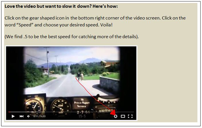
Wow – what a wonderful discovery Leigha! We slowed this footage down to 25% of its original speed but YouTube does allow you to slow the video down as well (gear symbol on bottom right of screen). Thanks for connecting with us and sharing your special history of this special place.
Thanks for this…. I grew up in Pemberton and spent the first 50 years of my life traveling the Sea to Sky Highway, and I well remember how twisty it was, not to mention that between Squamish and Pemberton it was still all gravel at the time. Britannia was a major highlight as you had to drive under all the conveyor belts that took the ore right across the road – this was fascinating to a 5 year old who was bored with a 3 1/2 hour drive and it meant we were getting close to Vancouver!
Also back then, the traffic was much lighter, and you always looked at oncoming traffic to see if you recognized the vehicles, often it was someone you knew, and you always waved.
Thanks for the trip down memory lane. My first trip to Squamish by car was in 1964 and I have lived here since 1971 so have seen many changes of the highway and buildings along the way. It was and still is the best place to live in BC
Anne, those conveyor belts you drove under were taking gravel to the other side
of the road to be loaded on barges…..the ore from the mine travelled on conveyor belts
that were covered until the ore dropped off the end into the hold of the ships.
My father loaded the ships and later my husband loaded the barges.
Glad you have a good memory of the trip.
As a former resident of Britannia Beach born in the early sixties, I can tell you that this is one of the most incredible series of images I have ever seen of where I grew up. The Britannia mining museum is a trove of old photos, but I don’t think I’ve ever seen images of Lions Bay without buildings, or anything close up of the gravel pits that used to be at Furry Creek or just south of Britannia, not to mention pieces of the road that disappeared 45 years ago when the new, widened road from Britannia to Squamish went through. This film was taken just before work began on that section, so it is especially valuable in historical terms.
BTW, the image at timecode 1:22 will be with me forever, as my mother painted it when I was just a kid. It shows up in this video exactly as I remember it.
Thank you so much for putting this on line.
Thanks you so much for this Ian, and sharing your story. We’re thrilled this could bring back so many memories for you, AND that your mom painted that image…that’s pretty amazing!
I had completely forgotten about the gravel pit at Furry Creek. Two parts stood out for me: Snake Hill just north of Browning’s Lake, and the par between Shannon Falls and the Hospital Hill intersection. Both of late, lamented memory. Will have to watch it a few more times using stop-time. Merci beaucoup!!
Glad you enjoyed it Gordon!
The wonders of the internet indeed…I’m not even sure how I hyperlinked my way here, but like Ian – I would like to thank you for putting this on line. It made me remember the many ‘rat-races’ we ran between Squamish and Vancouver along that highway with the guardian angels all working overtime. I drove the road between Britannia and Horseshoe Bay so many times, I was anticipating many of the corners coming up well in advance.
This road looked the same in the 70’s and 80’s when my Mum had a place at Alta Lake – when Whistler town centre was the garbage dump!