While we have about 470 web cams offering more than 930 views that motorists use for safe travel in BC, we have other web cams with a special job, that you won’t see.
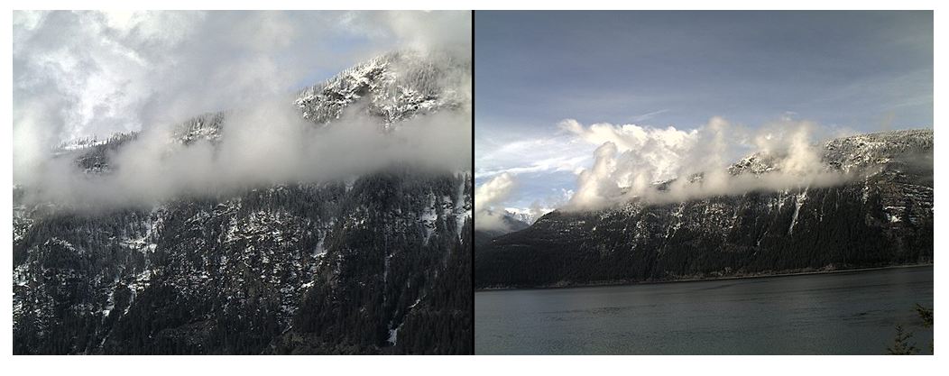
One that you won’t spot on DriveBC is near Highway 31 north of Kaslo, because its focus isn’t road conditions — it’s Lardeau Bluffs, which loom high above the road along Kootenay Lake. Avalanche technicians with the Ministry of Transportation and Infrastructure use the web cam as a tool to help forecast avalanche hazards and determine the best times for avalanche control.
First installed around 2012, the cam provides a close-up of avalanche start zones and a wide angle view for big picture information about Lardeau Bluffs. The camera was upgraded to the latest and greatest technology in 2018, and is used daily through the winter months. This camera was the first installation of its kind and a pilot project. Since then, cameras have been installed in other avalanche-prone areas of BC, to aid our avalanche technicians with monitoring and forecasting. During busy storm cycles, they allow us to be in more than one place at a time.
Faraway, Volatile and Challenging
Avalanche Technician Kevin Maloney describes Lardeau Bluffs as “faraway, volatile and challenging to reach and work on.” The area along Highway 31 is the sole link for the small communities of Argenta, Meadow Creek, Johnsons Landing and Cooper Creek. Avalanche work must be carefully planned to minimize economic costs for businesses and inconvenience for citizens. Economic example: the local sawmill must stop operating, when the route to the hospital is closed. Inconvenience example: school buses travel the route and there are a few cat-skiing operations along the way. (For those unfamiliar with this type of recreation, you won’t see felines flying down snowy slopes; cat skiing is back-country downhill skiing accessed by fully tracked vehicles).
Given those factors, the web cam is a huge help in the avalanche-active southeast corner of the province, where the Kootenay Regional Program manages 300 avalanche paths in 20 distinct avalanche areas spread over four mountain ranges. Every 30 minutes it offers avalanche technicians views of what’s happening at Lardeau Bluffs, without them needing to travel there. The webcam shows the snowline, freezing levels, wind, precipitation and sky conditions.
Focusing Our Efforts
When winter storms hit everywhere at once, the web cam helps avalanche crews focus and prioritize their efforts.
If the conditions on the web cam show it’s getting near time to remove snow from the bluffs, the sky view helps technicians determine whether visiting by helicopter for hands-on snowpack observations or avalanche control, is feasible. If the area is shrouded in fog (Kevin calls Lardeau Bluffs a “fog trap”) or blowing snow, then technicians will work elsewhere until conditions improve. Less time and money is spent on travel to the site, including helicopter missions that may be unsuccessful due to worsening weather. At the same time, web cam monitoring helps us keep the highway safe from avalanches.
It Pans, it Tilts, it Zooms!
The Lardeau Bluffs web cam can be accessed by technicians at any time and has remote control features to pan, tilt and zoom the view. Using web cams this way in B.C., is a whole new view of avalanche risk management.
However you look at it (even if you can’t see it on DriveBC) the Lardeau Bluffs web cam, just like our DriveBC web cams, has its sights set on safety.
What would you like to know about our webcams?
Thanks for explaining what that tower-thing is! We can get pretty suspicious over in this neck of the woods!