
Weather in BC can change rapidly, especially in winter. Just take a look at the Coquihalla Highway, where drivers can experience a wide range of weather systems from bottom to top of the mountain pass. And in milder parts of the province, temperatures often hover around freezing, threatening icy conditions.
There’s been a lot of discussion lately around how the Ministry of Transportation and Infrastructure and its maintenance contractors oversee weather fluctuations in our effort to pre-empt hazardous driving conditions.
To determine how best to protect travellers, the ministry and maintenance contractors oversee weather in two ways:
Monitoring: We have a weather monitoring network consisting of three different types of stations:
- Road Weather Stations (RWS): 99 roadside stations measure site-specific highway data such as pavement surface temperature and condition, precipitation, snow depth, air temperature, humidity and wind. Some stations have sensors directly linked to highway overhead message signs, so travellers receive timely warnings for poor conditions such as slippery surfaces. Vancouver Island drivers can see two of these signs on Highway 4 near Kennedy Lake.
- Remote Avalanche Weather Stations (RAWS): At times, Mother Nature threatens well above highway surfaces, too. As we’ve seen recently, avalanches can be predicted and controlled using information gathered from 67 remote mountainside avalanche weather stations strategically located in high risk areas across the province.
- Frost Probe Stations (FPS): 91 stations monitor threats below the road surface. Some are located at Road Weather Stations and others on their own. The frost probes measure temperature below road surfaces to gauge road strength, mostly during the spring thaw when load restrictions are needed.
Environment Canada also contributes to this massive weather watch, providing regional forecasts to the ministry and our maintenance contractors. Combined with additional weather information from sources such as airports, these monitoring tools help us predict road conditions. But firsthand experience is also a big part of knowing our roads. That’s why maintenance contractors and ministry staff patrol the highways on a regular basis.
Road Weather Forecasting: Environment Canada’s Meteorological Service of Canada does not do road weather forecasting. This vital service is only available through private sector service providers. The ministry contracts with NorthWest WeatherNet, a leading road weather forecaster, which watches over BC weather 24 hours a day, seven days a week.
All the data from each Road Weather Station (or, RWS, if you prefer) is analyzed and translated by NorthWest WeatherNet’s team of five professional meteorologists. The manager of WeatherNet’s British Columbia forecast team is based in Kamloops, and he is supported by a team of four other forecasters based at the company’s headquarters near Seattle. On any given day, the team will consist of one to three forecasters depending on weather complexity.
Wondering why only one meteorologist is based in BC? In our age of instant electronic data access, location is simply not a factor in weather forecasting. We have a close relationship with the meteorologists, who have closely studied the terrain in each forecast area and have visited all of our Road Weather Stations to discuss local weather effects with those who rely on their forecasts.
NorthWest WeatherNet delivers forecasts for each weather station twice daily, at 5 a.m. and 3 p.m., to enhance strategic planning, scheduling, and deployment of resources by our maintenance contractors during the winter months. These forecasts include hourly pavement temperature predictions and weather expected over the next three days. We combine these forecasts with our own monitoring (ie. highway patrols) to help decide what operational actions to take. Is a highway at risk of forming ice? Does an avalanche threat need to be tackled?
We also have access to hourly station updates and the ability to set alarms for any type of weather criteria -from snow accumulation to road surface temperature. For example, if there is a concern that temperatures are dropping, we can set an alert to notify us when a specific temperature is reached, allowing crews to get out on the highway and apply salt in either solid or liquid (brine solution) form before freezing begins.
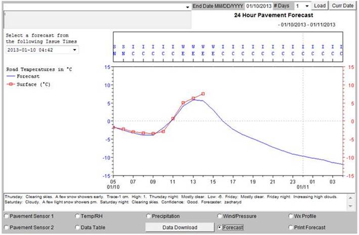
In the above graphic, for instance, the pavement temperature (red) and pavement temperature forecast (blue line) is shown. In this case, the maintenance folks could expect the pavement to fall below freezing at about 4 p.m. (or, 16:00 for you military types). There is also a brief text weather forecast in the bottom panel of the graphic.
Both those overseeing highway maintenance and avalanche technicians use roadside and mountainside station updates in their decision making. The meteorologists are also available over the phone, at all times, for more in-depth consultation if needed.
As you can see, we keep a close eye on how provincial highways handle changing weather patterns. We read the signs and work with our maintenance contractors to prevent Mother Nature from getting the upper hand on your travels. Did you know that you can tap into our weather stations, too? Just visit DriveBC to view timely weather information and warnings. With DriveBC, it’s only natural to know what you’re driving into.
Do you have any questions about how we track weather around B.C. highways? Let us know.
OK. rd 97 pg 2 Vancouver. Kamloops. Williams lake..OK. cool pictures. 🥶 😎
Adrian Thomas .
Thanks, Adrian.
Hi there.
We would like to ingest real-time weather information from your network into our database in order to verify some model forecasts.
Can you tell me where we can access bulk data in real-time?
thanks!!
Hi David. You can find real-time access to road event info, including extreme weather conditions, at the Open511-DriveBC API here:
https://catalogue.data.gov.bc.ca/dataset/open511-drivebc-api
I am working on a climate project in the Qualicum Beach area (specifically Spider Lake) I know that the Ministry of Highways has a weather station near the area I am studying. Is there any means by which I am able to gain access to the historical data (the last Five years)? Thank-you for your attention, Rod Chilton, climatologist
Hello Rod,
We have sent your request to our weather data group and will let you know as soon as we hear back. Thanks!
Hello Rod – sorry for the delay in getting back to you.
Here’s the URL for our public data portal:
https://prdoas3.pub-apps.th.gov.bc.ca/saw-paws/weatherstation
We believe it’s station 63093 Cochrane that you are looking for.
Thanks again for connecting with us here.
Hi,
Have you got an updated link for this?
cheers,
Jim
Hi, Jim
https://prdoas6.pub-apps.th.gov.bc.ca/saw-paws/weatherstation
Here you go.
I see the weather on the roads via web cams, and it just seems that the data may be accurate and you know the weather conditions, and its not Transit that is at fault, it is the slow or non preventative response from the maintenance and contracted companies paid to look after the highways and byways that is frustrating.
Hi Ann, thanks for your comment. Have you contacted your local maintenance contractor or your local district with your concerns?
Here’s the link for maintenance contractors: http://www.th.gov.bc.ca/popular-topics/maps/serviceareacontacts.htm
And the link to district offices: http://www.th.gov.bc.ca/contacts-regions.htm
Or, if you’d prefer, please let us know if there’s anything specific you’d like us to pass along.
is there somewhere that historical weather reports are kept?
Hello Monica,
Environment Canada has historical weather reports which the public can access. Here’s a link: http://climate.weather.gc.ca/historical_data/search_historic_data_e.html
Hope that this helps!