Ministry staff and our highway maintenance contractors work around the clock to keep travellers on BC highways moving safely, but sometimes extreme weather (or other emergency conditions) create special circumstances that can pose challenges for motorists. When that happens we place a specific travel advisory on DriveBC to help bring attention to the event and help travellers make better plans based on those conditions.
We take a number of factors into consideration when we post a travel advisory, such as:
- What time of year it is (sometimes an early season snow fall can catch motorists off guard)
- What kind of event is forecast (extreme winter weather, freezing rain or heavy smoke can make driving really challenging)
- Previous weather events and outcomes (historical incidents in a given area due to the highway geometry and geographic location)
- The topography of the area in question (some spots get walloped more than others because of high elevation, proximity to water bodies, etc.)
- The frequency and duration of the event(s)
Who Makes the Decision to Post a Travel Advisory?
Local ministry staff is in constant communication with the maintenance contractor in their area and across other contract areas, if the event is larger. When a dramatic shift in weather is forecast or an emergency condition arises (for example: the first significant snowfall of the year, exceptionally large snowfall accumulation, blowing snow and reduced visibility, heavy smoke from forest fires), ministry staff and highway contractors will ensure the right kind of travel advisory is created and posted to the DriveBC website.
Where and When Do We Issue Travel Advisories?
Issuing a travel advisory that is timely, informative and effective can sometimes be as challenging as the event itself. Weather systems can move pretty quickly and can sometimes be highly variable in the amount and type of precipitation they deliver. We also recognize that the public needs to trust in the message we are sending, which is why we limit the length of time travel advisories are in place, putting them up on DriveBC only when they are required.
Depending on the time of the year, we may post a travel advisory to raise driver awareness at the beginning of the winter‘s first snowfall in order to help remind travellers to be ready to adjust their driving behaviours and to drive to the conditions. Those first flakes of snow can be a real rude awakening for drivers, but once they have adjusted to driving in the snow again, those same conditions won’t warrant an advisory, as folks have shifted into winter and adjusted their driving to conditions.

Keep it Simple
Being too wordy about anything can lead to confusion, which is why we try to keep our travel advisory language simple. In order to be sure that the public understands the highway reference points being used, we aim to reference local community names or easily identifiable landmarks.
We break our travel advisories into two categories:
- The first is a proactive advisory – one that gives the public advance notice of an anticipated or forecasted event.
- The second type of event is a current advisory. This is an immediate warning that an event is occurring.
We tailor our messaging to the type of event expected, but typical messaging may include language about: expected conditions, exercising caution, considering alternate routes, making alternate plans, preparing for delays and planning for closures or expecting detours.
All Advisories Are NOT Created Equally
While inclement weather forecasts should always be a consideration during highway travel, it’s important to note the difference between Environment Canada Weather Warnings and the Ministry of Transportation’s Travel Advisories. The expert team at Environment Canada produce detailed information about the type of weather that travellers can expect on their journey. Our staff and maintenance contractors work around the clock monitoring specialized weather reporting tools and forecasts and will issue a travel advisory if it is warranted based on road conditions.
We hope that this helps answer your questions about how, why and when we issue travel advisories for BC highways. If you have a question about this, or anything else we do, please let us know in the comments below.
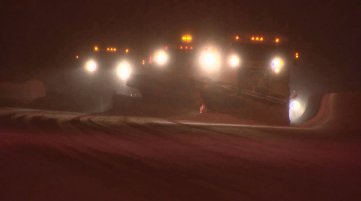
A snapshot of the Coquihalla during a recent travel advisory period.
All I want is an update on the Island highway closure not advertisements for the great things you’re doing. Terrible website.
Hi, Jamie
Thanks for sharing your opinion with us here. We encourage you to check DriveBC.ca for all highway closures and events. Hope this information is helpful.
Why does the highway 5 have a travel advisory every Sunday?ctv stated it was closed every Sunday? I’m planning on going on it in two week,and it sounds like I should wait until Monday to travel? No explanation on web site as to why there is an advisory?
Hi Gerry,
Some people and media that have been using Google Maps for Highway 5 road conditions, are receiving incorrect information from that source.
For current information, from the people who work on and near BC’s highways, please check DriveBC.ca Here is the web address for conditions on Highway 5: https://www.drivebc.ca/#listView&road=Highway%205
You will see that traffic is expected to be delayed by the lane width restriction of 4.2m at Henning Bridge, on Sunday, July 24. However, this is not a closure.
Does the travel advisory on Hwy 97 – 70 mile to 93 mile mean the road is closed. To make people aware it should state that.
Hi Ian – thanks for connecting with us here. The road is open but there is a travel advisory on DriveBC for this stretch to indicate that the situation there is serious and could change quickly – if you must travel on this road please do so with this in mind and be aware that smoke from fires will impact visibility and travel times. We hope that this is helpful.
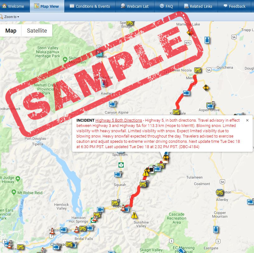
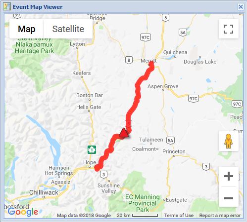
Here is the current DriveBC incident messaging: Highway 97 – Highway 97. Travel advisory in effect between Big Bar Rd and 94 Mile Frtg for 54.6 km (7 km north of Clinton to 4 km south of 100 Mile House). Because of forest fire. Limited visibility with smoke. Watch for speed reduction due to crews working.
Can you tell me due to hwy 1 closer in golden bc hwy 93 and 95 are the routes posted to take. I’m in a 18 wheeler and I know 93 is a no truck route I need to get to Calgary ab which route can I be on to get me there
Good morning Kayla,
Thanks for connecting with us here. The detour for all vehicles, including commercial vehicles is Highway 93/95. This route was reviewed and improved prior to the closure of the Kicking Horse Canyon to ensure it could accommodate large commercial vehicles. That being said, you could also take Highway 5 north to Valemount to connect with Highway 16 and cross the AB border that way. Alternatively, you could take BC highway 3 to the AB border. We hope that this information is helpful.
I would like a printed road map,thank you. Michael Newkirk 5658 60th Ave Alta,Iowa 51002
Hello Mr. Newkirk,
Please forward your request to HelloBC here: https://www.hellobc.com/plan-your-trip/maps/
Thanks and enjoy your trip to BC!
I’m trying to find how long Highway 1 was closed south of Boston Bar after 630pm February 13, 2019 heading south. There was a roll over and I ended up taking an alternate route to Abbotsford which took 4 hours longer. Maybe I should’ve waited it out.
If you can help me find how long it was closed for I’d appreciate it.
Thank you.
Hi Jen,
We are pulling this data for you. We will get back to you shortly with the info. Can we email it to you at the email provided?
Hello Jen,
DriveBC reports indicate that the closure lasted until 8:56 pm at which time the road was re-opened with language stating drivers should expect delays due to congestion.
Hope that this helps!