![]()
History and infrastructure nerds rejoice! We’ve collected a stunning group of photographs documenting the construction of the Fraser Canyon Highway beginning in the 1920s, and moving into the 30s, 40s and 50s. We’re excited to share them with you here, along with a bit of Fraser Canyon route history to boot.
Why all the Fuss about the Fraser Canyon?
The Fraser Canyon was home to the first gold rush traffic in BC, which began in 1857 when gold was found on the banks of the Thompson River, north of where the town of Lytton is located today. When news of the “New El Dorado” in the north made it south to San Francisco, the rush was on. Thousands upon thousands of prospectors came to the area in an attempt to strike it rich. Most arrived by boat at Yale near the start of the Fraser Canyon, but the rest of the journey was by foot or wagon on the Cariboo Trail.
As prospectors spread out and settled into the country, the wagon trail became an important route for supplies of all sorts. The Yale Cariboo Wagon Road became the preferred route for stage coaches and freight wagon companies and was widened and improved in many areas to keep good moving. Communities along the route also boomed at this time: Yale, Hell’s Gate, Boston Bar, Lytton and Clinton to name a few.
After the gold rush (and the construction of the Canadian Pacific Railway through the canyon) the Yale – Cariboo Wagon Road was largely destroyed and abandoned; however, the automobile craze of the 1920s generated a renewed interest in the route and so, between 1924 and 1939, the Fraser Canyon route was reborn as the Fraser Canyon Highway. The rugged canyon and the roads carved into the mountainside gave the motoring public quite the thrill and in 1962 this section of highway was officially designated as BC Highway 1 (part of the Trans-Canada Highway). We continue to work on improving safety along this famous route for the travellers of today and tomorrow.
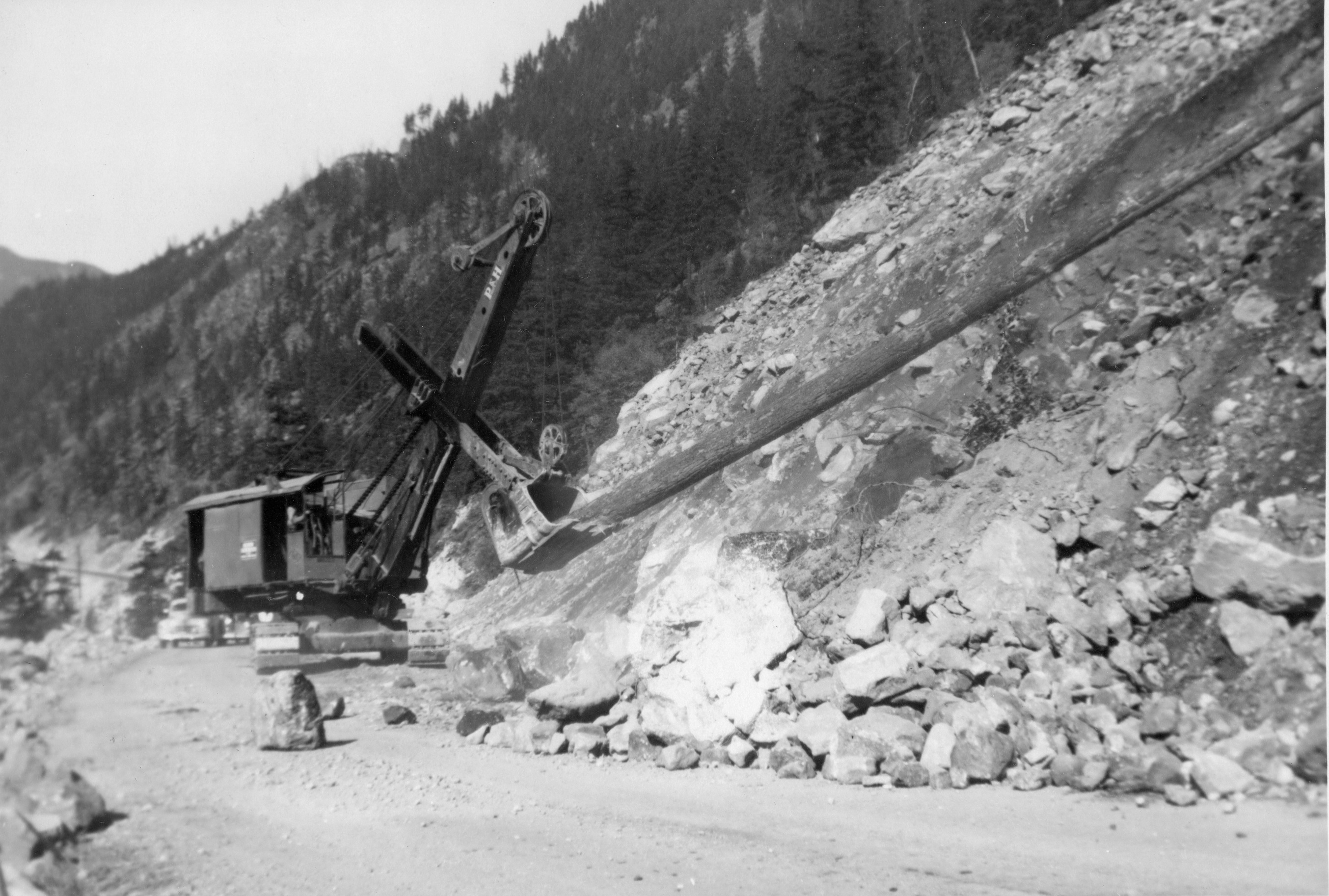
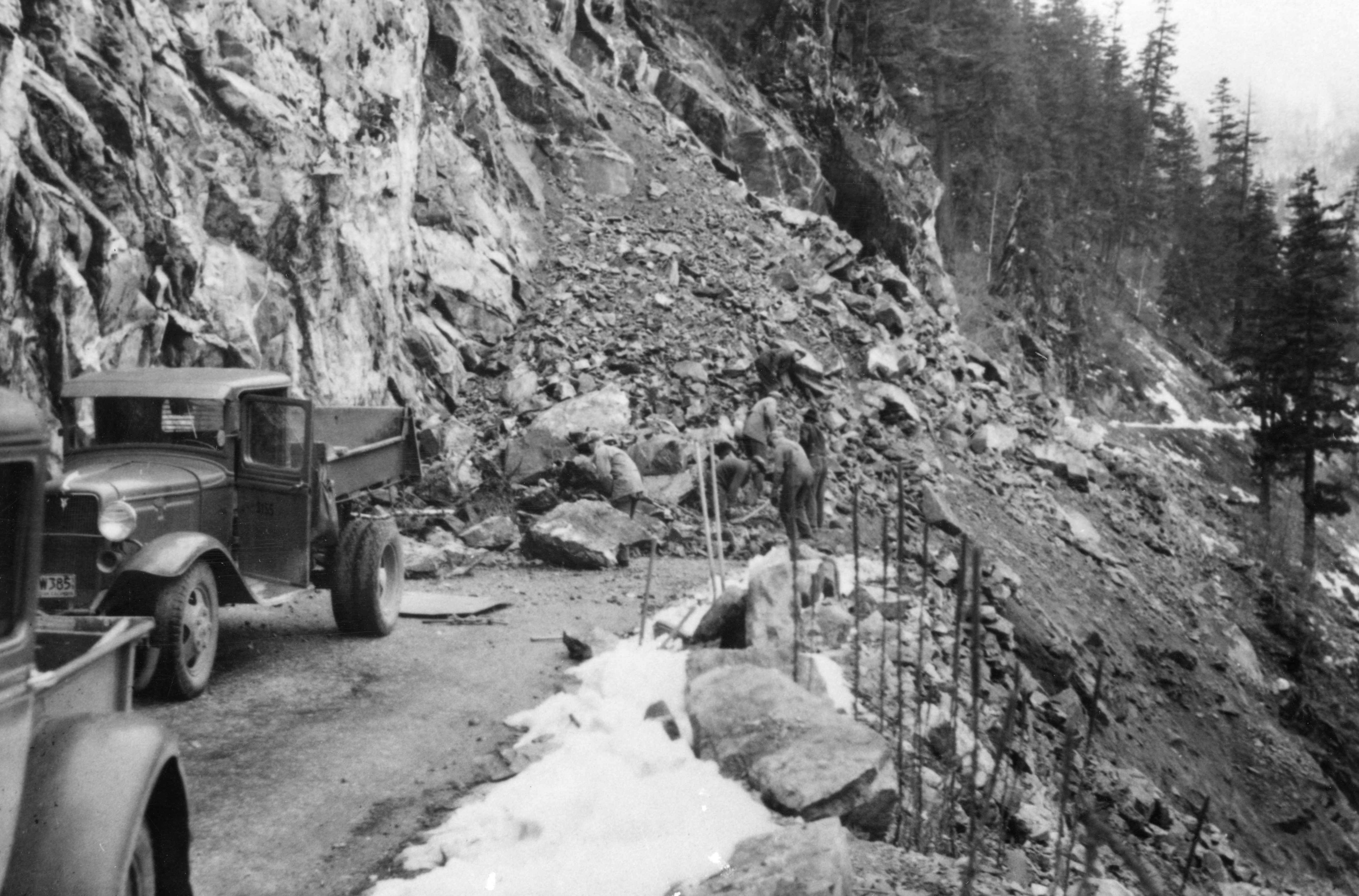
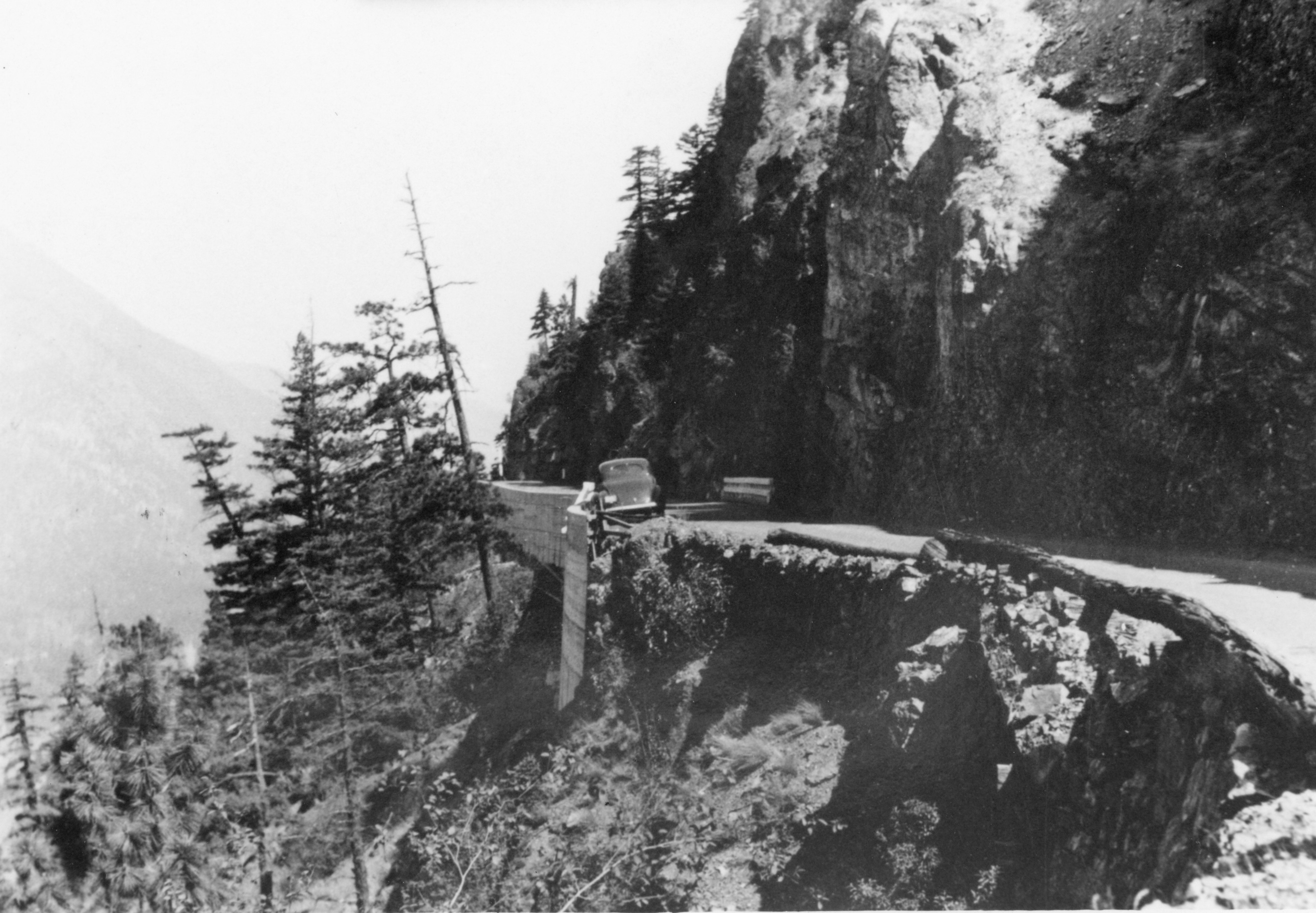
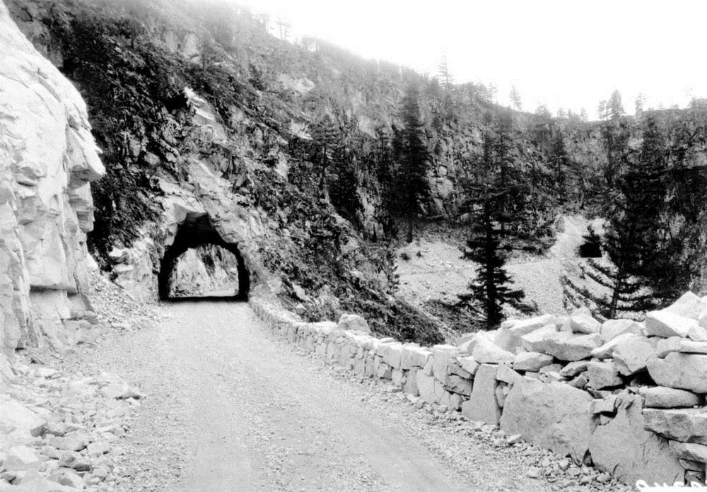
Reconstruction in Pictures
Have a look at the photos of the reconstruction below and let us know what you think. If you have any comments about this, or any other work we do, we’d love to hear from you!
I can remember going from home in Richmond to visit family in Lillooet in our new car in 1953. The road was pretty standard until we got to Yale…then it was single lane in spots hanging out over the river. It was pretty winding in spots around the Alexandra bridge…We stopped at the Alexandra Lodge and bought gas. Then drove through a tunnel and on towards Lytton. The road to Lillooet from Lytton was pretty good…but gravel all the way. We reached some really narrow sections high above the river…there was loose rock on the road that had tumbled down from the steep cut..these had to be moved and then drove around the ones we couldn’t move. It took all day to get there. A trip I will never forget.
Thanks for sharing your road trip memories, Bryan!
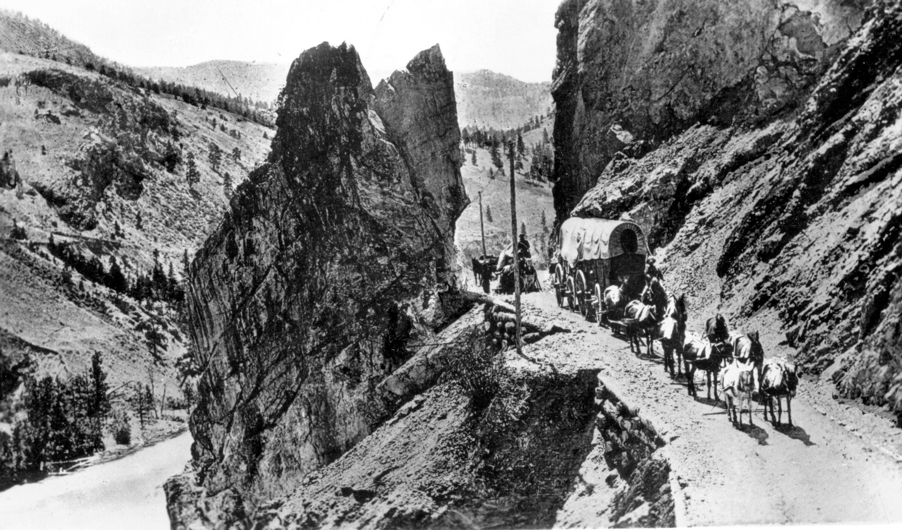
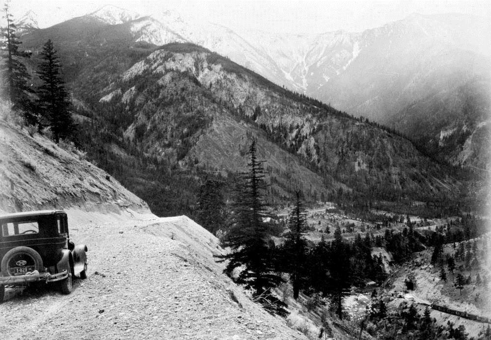
What a view! An early motorist is rewarded with the sight of the stunning Fraser Canyon.
This actually Gladwin BC in the Thompson River Canyon.
https://goo.gl/maps/vAbhQa2Bo4ZNfF6s7
It must be beautiful!
I remember as a you boy in the mid fifties going to Van.with my mom and dad and driving the piece of road that was built out from the canyon wall scare for a prairie boy.
Thank you so much for posting this history and amazing photos. My husband and I have travelled extensively throughout BC and recently we recreated the wagon train photo (my favourite) – with our pick up truck – in the exact same spot. It was an adventure and made me appreciate how easily we travel 150+ years later!
Good morning Dawnelle – how cool is that!? We’d love to see it – if you follow us on FB or Twitter or Instagram – maybe you could tag us? We certainly do have it much easier these days, don’t we!?
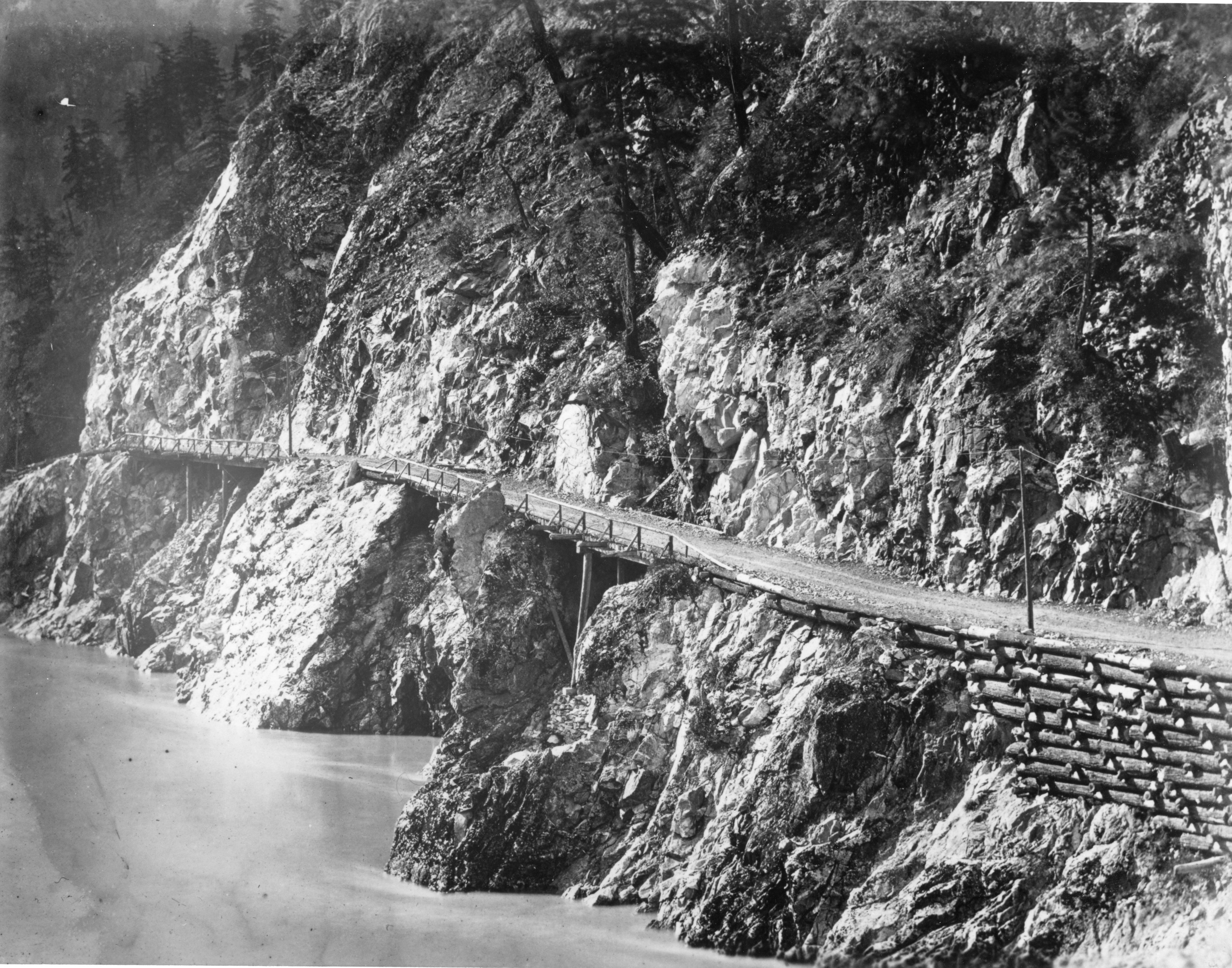
I recall as a child, driving up the Canyon to the Boston Bar area during the 1950s. I remember the drive as being very scary – walls of the mountain on one side and the raging river below on the other. I remember seeing the roadway built out from the mountain wall – I don’t know that we drove on it, or did I see portions of it. Were there any portions of that old roadway left to travel on during the 50s? At any rate, it struck great fear in my heart. Driving the Canyon now is pure pleasure – whew! Can any of that old roadway (cantilevered) be seen today?
Love reading the memories!
Hi Judi – thanks for sharing – glad to hear your modern trips through the canyon are not scary 😉 There may be locations where the original roadway are still visible, perhaps someone reading this might be able to advise.
Remember stories my Dad used to tell me from early 1930’s, backing up 1/4 mile in the Fraser canyon because vehicle coming other way, not enough room to pass.
i had a cousin who died in 1929 in the Frazer canyon. i suspect during construction but i was told he died under suspicios surcomstances. heinrich janzen.
Best thing that ever happened to this highway was the building of the Coquihalla highway. Before that, this was such a busy, difficult route to navigate. Now it’s just a blast to drive. Will be interesting this summer to see all the damage caused by the floods in November.
Thanks for your comments, Greg, about the difference the Coquihalla Highway made to traffic on Highway 1 through the Fraser Canyon. The damage to both routes from November’s extreme flooding was extensive and it will take years to fully recover. Please plan for extra travel time given the temporary repairs, construction areas and work underway. More about what recovery will look like on our highways: https://www.tranbc.ca/2022/05/10/bc-flooding-what-does-the-road-to-recovery-look-like-for-our-highways/
weve come a long way! i remember travelling on the old hyway in the late 1940.
The second picture in this series, where the horse team and wagon are going through the rock cut, was actually taken just north of Spences Bridge, on the South Thompson river.
Hello there, Is there someone I could contact to confirm if we could use some of these photos for a series on the knowledge network?
Hello Lanna,
Thanks for connecting with us here. Please apply for permission/license by completing our online Copyright Permission Request Form https://www2.gov.bc.ca/gov/content/home/copyright
Please ensure that the BC Ministry of Transportation and Infrastructure is noted and, if you can encourage people to view our other historical content on this blogsite. 🙂
Thank you!
Wow thank you so much!
Thanks for reaching out Lanna!
Is there a TranBC archives or historian and if so how do i contact them for information on the early years of the ministry?
Hi there Richard. We don’t have a dedicated historian, per se, although we do have people who are knowledgeable about the ministry’s history. What kind of information are you looking for?
I traveled the canyon in the late 1950s, I was so nervous I stood behind my Dad and told him where the curves were……I did not have a good holiday at Pavilion lake because I was afraid to go back down the canyon road! I love the road today and try to pick out the old road.
Ah, Pat – what a memory! We love that you love the road now. 🙂
Thank you for sharing the photos were awesome
Thanks Shirley! We appreciate the comment.
I am awed at the courage of the people who built the highways throigh the Rocky Mountains and can’t thank you enough for these pictures.
Thank you for taking the time to comment. It is pretty amazing, isn’t it?
Love the canyon. My parents bought the Rest. Cafe Post Office Gas Station in Spuzzum in 1958. We fed a lot of the construction working on the Alexander Bridge, Tunnels etc. I try and go there at least once a year to visit friends in Yale. We owned the place till 1972, the canyon is so full of history and so beautiful. Love your history in pictures
Thank you for sharing your family history in the area, Margrit. We’re happy you enjoyed the photos. I’m sure you have a good collection of your own!
Hi / Were your parents the French couple that had the waitress dress up in nice outfits? Very friendly people and nice dancers when they attended dances in North Bend/
One of my favourite day trips. Vancouver to Merritt. Lots of places to stop and discover. Interesting where the Thompson meets the Fraser. So much history
Agreed Wendy. Thanks for your comment.
Cool pics, they’re very interesting, as are the stories!!!😁
Glad you like them Jody 🙂
Stay tuned for more historical images.
My Great Uncle was one of the first to go over this highway in a car. They moved the barrier the very early the day before official opening to start back up to Prince George. They got very adept at changing tires and repairing flats over the very rough rocky road. The old wooden spokes of the wheels got very loose and the wheels wobbly so towards Spences Bridge they drove into the river and let the spokes swell up and tighten up before they headed off again.
With the TV Show “Highway Thru Hell”, the Fraser Canyon gets a lot of attention ( in color) with very nice views. 😊
It does! Thanks for the message 🙂
Great pictures. Have always been interested in the canyon. As a youth my dad hauled freight through the canyon and he always pointed out things from when he was a kid. For instance the old trail that snakes along the other side. Only sections are visible now as slides and erosion have taken much of it away. Sections of the old highway including the old hells gate tunnel that collapsed. Dad walked me through it and I have taken my kids through to stand over the highway on the other side.
As I said the pictures are great however your history is off by quite a few years. The gold rush started in the early 1800s and all the towns you listed along the canyon were constructed in the 1800s as well most of them as camps for the original “ wagon road” construction or as stop over points for the previous “ fur trail”
As a foot note my dad was in one of the last cars to drive over the old Alexandria suspension bridge. They drove over it as they were cutting the ribbon for the new bridge and had to wait on the North side for traffic coming across the new bridge.
Thanks for sharing your memories and comments with us Robert. We’ve noted in this piece that the Gold Rush began in 1857. While you are correct in stating that the communities along the river may have pre-existed the Gold Rush, we’ve updated the language to read that these communities also boomed at this time. Thanks again for your comments – safe travels!
I have about 10 of my great grandpas work picture’s of highway work being done
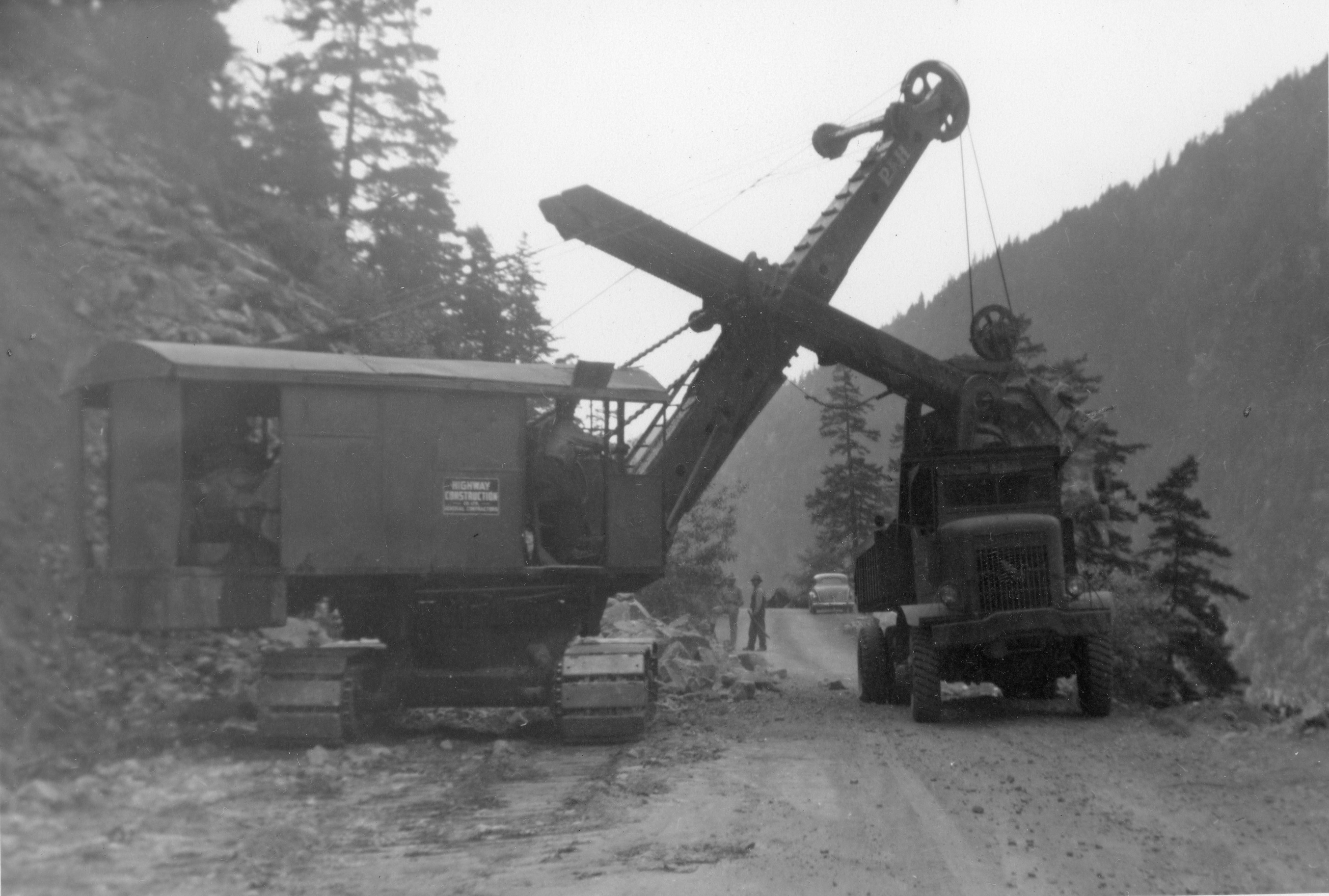
in 1936 that he titled Ashcroft Savana Hi-way.I believe they were widening and prepping to pave the road?Alot of the work is men and hand tools,a steam shovel or horse and I cant quite figure these out.
Sounds about right. We’d love to see them – any chance you could share to our Facebook page (@TranBC)? We’d love to see them.
travelled the canyon in 1947, with mom, dad and brother in dads 1935 olds. a real adventure for the kids but terriyfing for mom. took three days to reach kelowna, with o/n stops in alexanderia and kamloops. good memories though.
Wow Cliff -sounds like an epic trip! (and we hope your mum recovered quickly).
Thanks so much for sharing with us 🙂
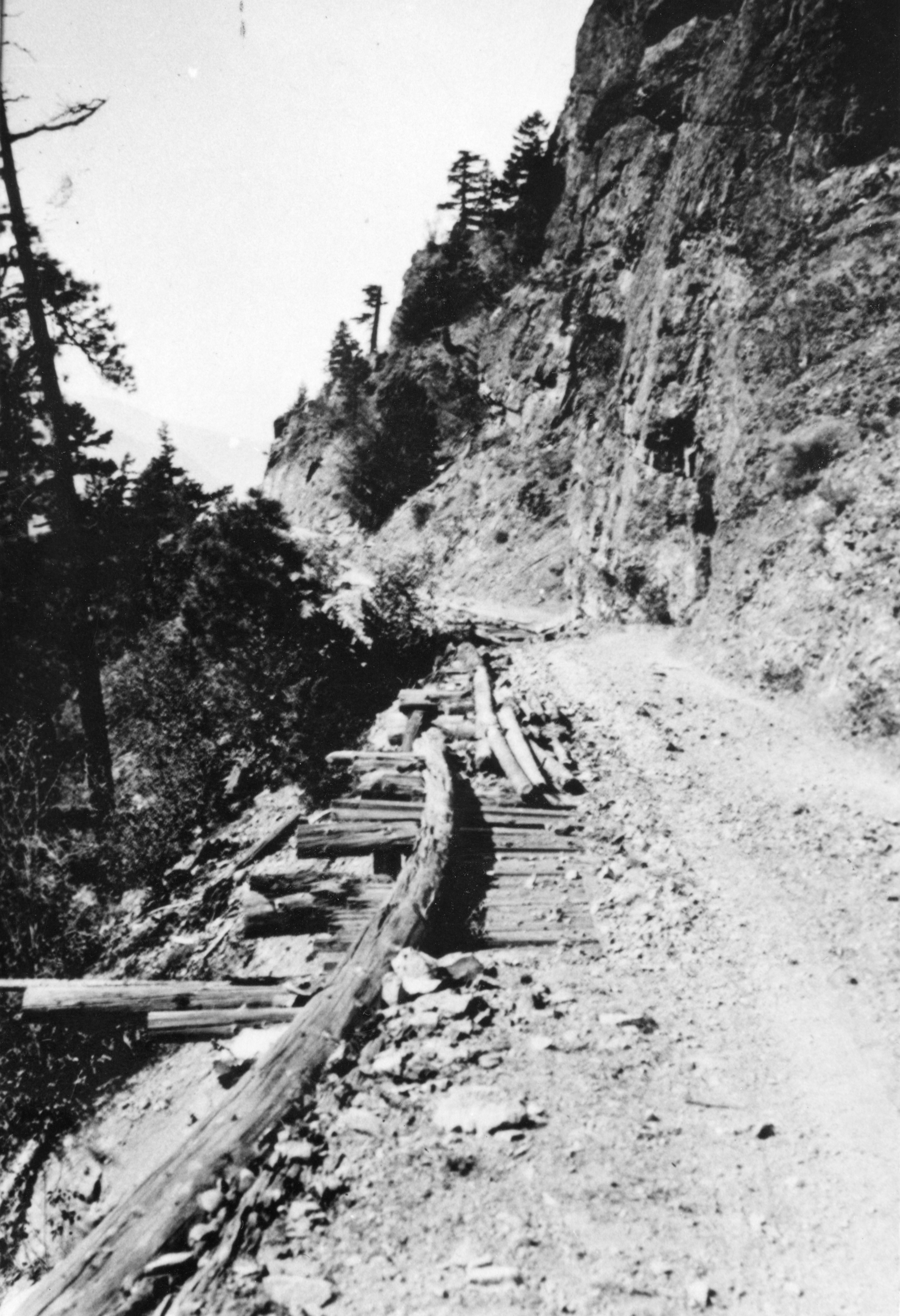
I have traveled the Canyon Road since 1952 and remember some of the road going into every crevas and some were beautiful, with water falls and places to picnic or camp, which have now been cut off. I also remember when travelling that some people were so scared they would not pass you, and if you stopped, they did. At times these people would beg someone else to drive their cars for them. I also remember the board bridges across where you could see through the gaps and the water running under you, as the road was much lower at places. There is a hole, high at one place now which was the road, and my Husband was a Greyhound Operator and used to drive through there with the bus. I love the Canyon but there so little time to enjoy it now. The speed at one time was 50 miles an hour and now up to 110 kilometers an hour and hardly a place to stop safely to just look and enjoy the gorgeous scenery.
I went and walked a portion of the old road today, just before the first tunnel above Yale.Many parts of the asphalt road are still visible but with trees growing out of it.I enjoy comparing the old pics to the pictures I just took.Thanks for sharing,it’s an amazing area.
Thanks for sharing your old road adventure with us Paul!
In 1957 my family traveled the Fraser canyon on holidays to Canim lake. Five of us in a Anglea car. The dam thing was so narrow the wheels came off the ground on the corners. There was stopping place at dogwood. There were pictures and stories about Cog Harrington and his time as a mechanic and tow truck operator. In 1969 my parents purchased Hungry Herbies in Cache Creek. We moved in1960. I worked with a mechanic Jack Robertson 3A motors and learned the trade towing and repairs. In 1964 the Alexander bridge opened and it allowed the larger trucks on the road. I got busy doing truck repairs and towing. Started my own business in 1969. Chanor truck repairs. I am still working 60 plus hrs a week. I have a wall of recovery pictures
Thanks for sharing your memories with us Chuck! 🙂
I’m amazed at how good the camera lens were back then, great pictures.
I worked on the highway from Hope to the Alexander Bridge with the survey crew and saw the first Euclyd bought by Emil Anderson Construction haul the first load and dump over the river side.I lived in Flood and my Dad helped put in a lot of power and telephone poles from Chiliwack over to Princeton and worked in the construction camp on the road from Hope to Princeton.Went to school in Hope we’re some of the Japanese kids from the interment camp also went ,one of them was my very best friend.
Thank you for sharing your stories Peter! We love hearing them 🙂
Excellent archival shots of the old canyon road. One small understandable error: the second shot from the bottom (“What a view!….”) is actually taken in the adjoining Thompson Canyon, a few miles east/northeast of Lytton and just east of Skihist Provincial Park. The view in the shot looks roughly east towards the small settlement of Gladwin, where the old Gladwin Court motel and gas station was located (remnants of it are still there). Many people mistake this part of the Thompson Canyon for the Fraser Canyon, as the geography is similar and the Thompson River is only a few miles from its confluence with the Fraser. As a boy, on numerous car trips between the Interior and the Coast, I was often confused myself as to where the Fraser Canyon started.
Wow Russ – great comment and thank you for the catch!
I have photos from my dad when he worked for the electric company setting poles and running lines up the canyon if anyone is interested. There is some talk among my older friends of the company being the predecessor of bc electric. I’d be happy to share them.
We would be soooooo happy to see them Robyn – thank you!
Hello my dad Peter Dyck helped in building of he Fraser Canyon hwy, I don’t remember the year but when we traveled the hwy from Armstrong BC to Vancouver he used to tell us stories as we drove the fraser canyon through the tunnels. He drove a uklet for Emil Anderson Construction back then. I sure miss them stories now
My dad was almost caught in the Hope slide
Glad to hear he didn’t Randy.
A friend of mine’s Dad was supposed to be driving that hay truck.
A friend of mine’s dad Mr Thomas Starchuk was driving the hay truck.
So cool – your family connection! Thanks for sharing Jim.
Thanks for this information Randy! We love hearing from past staffers and their families 🙂
My dad worked with George Hood at the bc electric when George got the idea to retire and invest into Alexandria lodge,He also just about talked the old man into being his partner.Thankfully my dad mmust have found out the govt.was changing the road somewhat & ended up putting a steep hill just a few feet north of the lodge.Pop was lucky on that deal and forever talked about how George figured he was going to make a hunting & fishing lodge at that part of the canyon.I drove for Vancouver Merrit years later & stopped a couple of times to say hello(on the way home trip) “the hill, loaded”.He and my dad were true friends for years and the odd time they would let the kid with the runny nose tag along up to the Vedder river.No wonder I still have “RESPECT”for my elders
Thanks for sharing your story with us Sam. Yes, there were many interesting stops along the old highways of BC. Time for us to re-visit Gold Trails and Ghost Towns!
The hamburgers at the Alexander Lodge were the BEST.
ever since I was born, 1960, I have been in my parents vehicle driving to and from Vancouver to prince George twice a year for over 15 years. I have seen changes in the highway. it was single lane most of the way, twisting, winding up the mountains and back down to the fraser river. I would always say, up and down, back and forth. as the newer highway was being built you could follow the old road with your eyes as it would cross going way up the mountain, then cross again going way down to the fraser. I would watch for it the whole way through the canyon. I found it amazing to say the least. back then it would take 3 days to make the trip, now it take 10 to 13 hours. im sure i saw sturgeon in the fraser river when i was young, that’s how close the road was to the river at times in those days.
Hi Joane,
Lovely to hear your reminiscences of the Fraser Hwy. Sounds like enjoyable childhood travels, that you still appreciate today.
these photos are amazing!my great gramps worked with Cataline mule packing up the trail during 1890’s up to 1912. Then they packed north to Hazelton and into the Yukon from Ashcroft and Dog Creek.Leons Station roadhouse south of Big Bar on the old miners trail up the east side of the Fraser was great great gramps.That was during the gold rush era of 1858-62.We are Secwépemc nation from Big Bar too.
Wow! Thanks for sharing this with us! We love hearing your stories 🙂
Interesting to hear your story. My uncle, Henry Patton was born in Dog Creek in 1916. Still many Patton’s in Williams Lake area. My dad drove transport truck for D. Chapman & Co. Ltd. when I was born in 1952 on the Chilcotin Cariboo daily run from Kamloops to Williams Lake. In those days drivers had to load up and unload the freight. I’m not even sure in Cariboo hwy was even paved then. Phil Gaglardi’s election in 1952 focused major on the highways. By 1955 we moved to Williams Lake when dad started managing it there.
Hi Lorean,
Thanks for sharing your family’s history with commercial transport in the Kamloops and Cariboo areas, with us!
Yeah, Flyin’ Phil loved his highways; he was an infamous speeder, constantly getting caught by the police.
Wow – cool that your Great Gramps worked with Cataline! He must have been a pretty rugged guy to work on that crew. My Grandfather owned Larkworthy’s General Store in Hazelton. Cataline pack trains were a frequent sight there.
Keith any chance there are photos of Cataline pack train at Hazelton from about 1900-1912 in the local museum? There are a few in the Clinton Hotel.We dont have a photo of Serapio Leon and its kind of my mission to find one. He died in Ashcroft 1926 and we haven’t found his grave either.
In the fifties and sixties I worked on eleven bridges in the Fraser highway system. From the north at nine mile creek to the Willington overpass in the south. This included the Transmountain pipeline crossing at Flood near Hope. In between bridge building I did a lot of work in Boston Bar for Cog Harrington and others. I built the hotel addition first, then remodeled the Shell station. After that project I built a food drive inn. and a three story home, etc.
These are great pictures, It didn’t have a shot of the overhanging tressels a Spuzzum. Maybe someone has some to add to this. Well done. Thanks, Dale.
Hello Dale and thanks for your message. We love hearing from folks who had a hand in helping build BC highways – thank you for your work and for taking the time to share with us!
You keep saying Thank you….which is great, but maybe the response should be “Do you have any pictures to share”.
Hi Dee – we’d love to see any photos others have to share. Unfortunately – this forum won’t allow attachments. We encourage anyone who wants to share with us to connect with TranBC on Facebook, Twitter or Instagram!
in 1947 my mom,dad and brother travelled vancouver to kelowna via the fraser canyon and kamloops in dads 1934 olds. trip took 3 days with stops in chilliwack and a cabin around alexandra (still there), road rough, winding, narrow and at times single lane. weather and mechanical problems made this trip a real adventure for two young boys, but fun//.
Must have been an awesome journey! Thanks for sharing – we love hearing these memories. 🙂
Cliff do you remember Mr and Mrs Larry& Edna Green from Kelowna? I am the oldest daughter Joy (Joyce)
My MA Thesis at UBC Geography was an Historical Geography of the Trucking Industry in BC. It started in 1920. And much of the story was the ‘progress’ of road building. With improved roads came improved times. That and the technological development of trucks (with many local stories) are what brought the province together, not the least, as consumers. The story of the Fraser Canyon rears large in this story. Thanks for the photos.
https://open.library.ubc.ca/cIRcle/collections/ubctheses/831/items/1.0087073
Thank you for sharing this with us Rhys. The history and evolution of our provincial roads is a fascinating story, isn’t it?
Thanks for being so kind to share your Thesis!
I first road on the canyon Hwy in 1948 when my folks purchased a Motel in Lytton and watched Jackass mountain being widened in 1949. As I remember the road was narrow and winding through out but was paved from Hope to Kamloops. Some of that road is still there. the second Alexander Bridge was A steel deck the first washed out in high spring water. Cachcreek was nonexistant in the 50’s. But the Ashcroft Manor was in there as well as a lot of historic buildings are still in existence. This road on the average claimed a yearly average of one fatality a year to the Hope- Princton of Three in the first year of operation upon opening in 1953 as a through route summer travel only. Where as the Fraser Canyon route was all year.
We’ve decided to add you as an honourary member to our transportation history team Ian – you have so much history knowledge! Thanks for sharing this with us.
I have travelled back and forth on that highway from Langley to 100 Mile House visiting my Dad’s family. I have akways been in awe at the beautiful scenery. I was never fond of travelling on it in the wintertime, too scary for me. These photos are awesome. Thanks for sharing them with us. Brings back great memories.
Hello Terri and thanks for sharing your memories here with us!
My first experience of the Fraser Canyon was from the train trip Montreal to Vancouver this was in 1956.This was a fantastic thing to see for a Dutch teenager coming to this beautiful country.Seeing all the construction going on.
The following year I had the lease of driving from Vancouver to Litton.I remember the switch backs at Alexander Bridge and the cantelever Bridges hanging on the Canyon wall as it were.One can still see the old bridge from the New Alexander bridge, thanks for sharing the pictures
Bote Bouma
Thanks for sharing your memories with us Bote! We love hearing from folks like this. 🙂
My father worked on all of the present day tunnels in the 60’s. He was a drill doctor…..sharpening drill bits. For a young kid it was a pretty scary ride way back in the day. Thanks for the photos and information!
We are happy to share these kinds of things with you Sharon. Glad to hear you enjoyed them. Take care.
My grandfather told me what the road was like back in the 30s and 40s. And I remember hearing all about the one lane cantilever bridges. In 1968 I was on a train coming back from Winnipeg, and because the highway is mainly on the other side from the tracks, I could see all sorts of wrecks that were down the slope from the road. I wonder if they’re still there. As it is, now I drive a semi on that route every day. It’s a drivers road, and I curse when the Coq is a mess and all the morons use my road instead.
Wow Rob! What an amazing visual. They might have been cleaned up by now, but we wonder if anyone else has seen this? It is a beautiful drive to be sure and many drivers do prefer it over the Coquihalla. Thanks for sharing!
My dad shot 16mm for the CBC of the construction and re opening of the hiway in around 1939, apparently they deleted all the credits, I’ve never seen the movie, however my dad told me about it. The CBC should still have it in there archives, and I would love to see it. Has anyone viewed it it would be nice to know, he did mention a streach of the road that they touted as the million dollar mile.
Sounds like it would be great footage to see Dave – thanks for letting us know. We will have a look!
Our family moved from the interior to Surrey in 1944 and traveled this route. I was 11 at the time and remember it being very scary. Dad assured us that it would be fine when we reached Hope and had us looking forward to the new Patullo Bridge.
A sweet story Shirley, thank you for sharing it with us. 🙂
Having graduated from high school in Saanich spring of 1953 two of us traveled the canyon on our way to Smithers in late July that year. George v’s Model”A” Ford got us there but not before we experienced the cantilevered bridges?? no railings; very rough gravel/mostly crushed sharp rock road surfaces and NARROW portions with limited vision around the curves. Often we expressed concern to each other about on-coming- traffic and on several occasions were required to stop and reverse to wider (inside) pull-out to allow south bound vehicles to pass safely. As I recall these were often larger and more modern transports! We broke a gas line feed to the carburator just north of Spences Bridge and limped into Cache Creek just over 8 hours after leaving Hope. We were 4 days to Telkwa where we found work. At my present age 83 this is one adventure often relived. Thanks for the reminders!!!!
Wow Donald – thanks for sharing your memories with us here. Yes, the road has certainly changed since then, and this kind of story helps illustrate how far we have come!
Those are fantastic pictures & bring back many memories
So glad to hear that you enjoyed them Sheryl! 🙂
I remember driving through the Canyon in 1940 with my Mother and Dad when I was 11 years old. We were on our way to Chute Lake, between Penticton and Kelowna. The drive through the canyon was pretty scary because of the many narrow sections, switch -backs, tunnels etc. In those days we had many flat tires because of the gravel roads and of course the tires had tubes. Changing a tire was quite a chore, especially when you were parked on a narrow section of road. BUT, the scenery was marvelous. Great memories.
Thanks for sharing Robert!
My family and I travelled the Fraser Canyon in 1948, and at six years of age I can still remember the corduroy roads and very slow travel.
It was something to behold really.
My long term memory is very good and I can still visualize it to this day.
Great pictures.
Hi Harold – we are so glad to hear you enjoyed it. Thanks for sharing your memories with us!
love the canyon
Us too 😉
Thank you for this beautiful memory. I remember my first trip on this highway. It was 1940, and we drove from Princeton up through Spence’s Bridge to join this route. It was 313 miles, and two days, from Princeton to Vancouver then, shortened to 183 miles when the Hope-Princeton opened in November 1949. We did the trip west in a 1929 Chevy, and drove a brand new 1940 Oldsmobile back on its maiden voyage.
Wow! What a great memory Gregory – thank you so much for sharing with us. We love hearing these stories from folks out there who remember when. 🙂
Being a B,.C. history buff, this site is more than welcome.
Growing up near Trail, I remember the twrrible switch backs that went through WA Sate to get to the coast. I would like to see the construction that went on to build Hwy 3 if you have it on file.
Thanks
Hi Vic – thanks for your support! We will look for Highway 3 construction and share what we find!
BTW Are these photos part of the ministry’s collection?
“collection” is a nice term. 🙂 More photos we’re finding as we come across them.
Thanks for sharing these archive photos! I enjoyed seeing the progression and knowing more about why that road is there.
Happy to share, Trevor. Please pop back regularly as we’re always sharing a bit of BC history. Have you seen our BC Roadtrip Time Machine videos? https://www.youtube.com/watch?v=JqZO7YJPfPs&list=PLKHNpQ_j-IWG8CG_KN7cwl5mMO2bz2x8w
Very impressive that you have photographs of the very early stages of the Fraser canyon in your archives and that you post them. Our family came up to Williams Lake in 1958 and still remember some old trestles and hand built walls and waiting for tunnel blasting and road crews to do there work. How times have changed,from a 11 hour or 12 depending on work being done to 6 or 7 hrs depending where your destination is, keep up the good work. Glenn Lambe Wms Lake.
Hi Glenn,
Thanks for sharing your memories of the Fraser Canyon with us. Times certainly have changed!
What an amazing album! The historical info is very intriguing. Thank you for sharing with us!
Glad you enjoyed it, Terry!
The story and pictures are excellent! Now the real gems are you folks putting down your family history, priceless! Photos will last but the stories die with people unless they have written it down!
Some of you have mentioned your old photos, no time like right now to jot down on the back of them where and when it was taken. PLEASE becarefull documenting your photos!
All of you made my day!
We second that, Tim!
There were tragic stories from the Fraser Canyon too.
A young couple named Turner from Salmon Arm were just married and set out on their honeymoon.
Their car went off the road somewhere in the Canyon, not sure where and they were both killed.
I remember as a young man in Salmon Arm seeing their wedding procession, and shortly thereafter the funeral procession.
Very sad indeed.
Oh dear, that is very, very sad indeed. Thanks for taking the time to share that with us here, Dennis. Safe travels.