What’s the flattest route to drive across BC, if you’re taking a road trip, and bringing your accommodation with you?
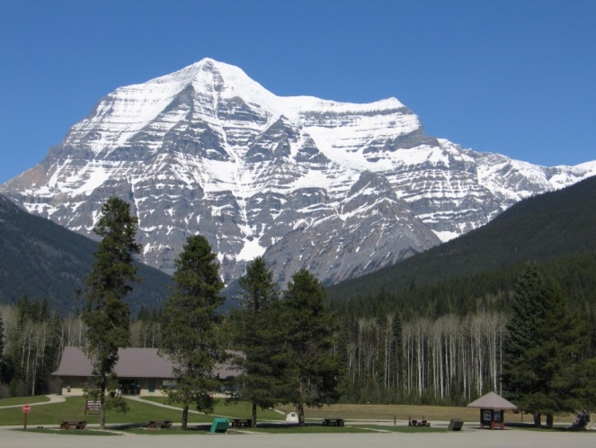
We in BC tend to take our mountainous terrain for granted and those glorious summits somehow become a backdrop to our everyday life. But for less familiar travellers of our province, those snow-capped peaks can be a little intimidating, especially if you drive an RV or fifth wheel, or your vehicle struggles going uphill. That’s why it shouldn’t be a surprise that one of our most frequently asked question is: “What’s the flattest route across BC?”
So, if you’ve come here looking for a route through our province that’s scenic but not too steep, we’ve got you covered.
 Our Mountainous Grades Explained
The reality is that there’s no way to avoid some mountainous grades in BC. It’s just part of who we are.
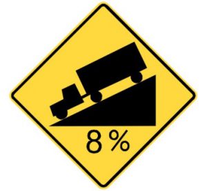
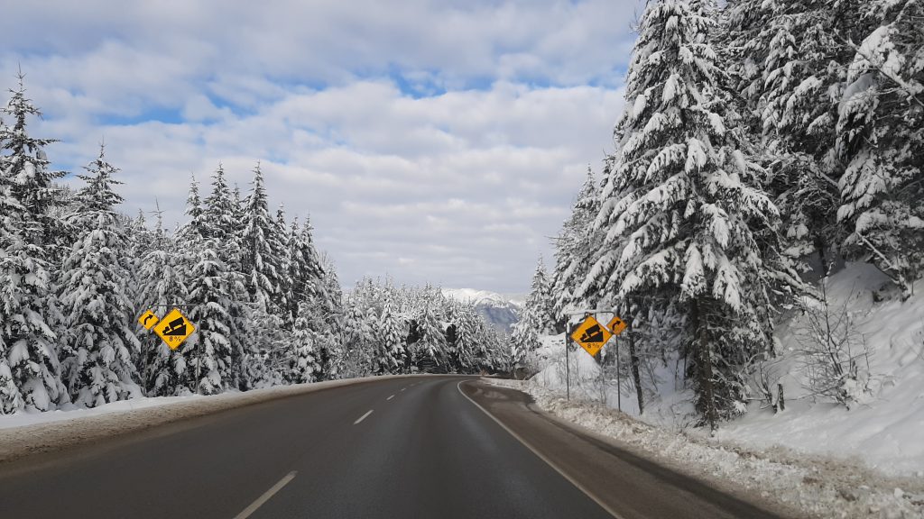
The issue for vehicles is really never the steepness of the grade, but the overall length the grade is carried over. The Coquihalla, Rogers Pass, and the Salmo-Creston have the longest stretches of grades carried over in the province. They tend to be 8%, but can carry over distances of 20 kilometres or more. Our grades are typically about 8% (maximum) with a few grades that exceed this (9%-12%) over short distances. Most modern vehicles can handle any grade on our highway system these days, especially if you get the towing package on your vehicle.
How to Tackle BC Terrain
On the Uphill:
- Go slowly – the biggest problem people have is overheating when they “push” their vehicle too hard.
- Reduce your speed on the long hills to avoid overheating your vehicle.
Going Downhill:
- Watch for “Steep Hill” warning signs.
- Make sure your brakes are in good working order and remember – in the event of an emergency, runaway lanes are located along steeper grade descents in case you need them.
- If you’re a commercial driver, use the brake checks to test your brakes.
- Gear down on long descents – use your vehicle’s engine to slow you. Shift into a lower gear if you drive a manual transmission vehicle. If your vehicle is an automatic, slow down, then shift into a lower gear.
- Gearing down will slow you, so you won’t need to use your brakes all the time. “Riding” your brakes can overheat them. This will wear out your brakes and you could actually lose them (and their stopping power) altogether if you don’t give them a break.
- If you still need to brake much of the time, shift into an even lower gear.
- Once you and your automatic transmission vehicle are on flatter terrain, shift back into “D” for “drive”.
Always:
- Check DriveBC.ca. This is our traveller information website. It’s where we share all of our road condition and closure information. If it’s happening on BC Highways, you’ll find it here.
- Be prepared. Mishaps and unforeseen circumstances happen, and being prepared for them can go a long way. Make sure you have plenty of food, water and spare clothes – just in case.
Heavy Vehicles (and Some RVs) Stop for Brake Checks
Drivers of heavy commercial vehicles (and also drivers of pickup trucks towing a large RV with a gross vehicle weight of more than 5,500 kilograms) are required by law to check their brakes before travelling down steep grades that are posted with regulatory signs.
Note: if you’re pulling an RV that weighs more than 4,600 kilograms when fully loaded, you’ll need either a House Trailer or Heavy Trailer endorsement on your Class 4 or 5 license. If the trailer weighs over 4,600 kg GVW, and there are air brakes on either the trailer or tow vehicle, you will need to upgrade to a Class 1 commercial licence. For other requirements, see ICBC’s: Licensing for recreational vehicles fact sheet.
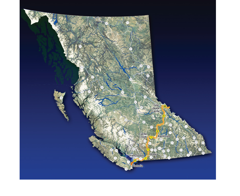
What is the Flattest Route Across BC? Heading west:
- Alberta Border at BC Hwy 16 to Hwy 5
- Hwy 5 to Kamloops
- Kamloops (Hwy 1) to Cache Creek
- Cache Creek (Hwy 1) to Hope
- Hope (Hwy 1) to Vancouver
- Hwy 17 Tsawwassen Ferry Terminal (Vancouver) to Swartz Bay Ferry Terminal (Victoria) via BC Ferries
Read this list in reverse if you’re heading east from Victoria or Vancouver, toward the Alberta border.
Prefer it in a visual? Here you go!
A Note for Cyclists: This route was identified as the flattest for motorized road trips. It is still the flattest route for cyclists travelling across the province, but keep in mind that the flattest route isn’t the shortest one. Also, some sections of Highway 1 have cycling restrictions.
We hope that this helps you in your travels. If you have questions about these highways or anything else we’re involved with, let us know in the comments below. Safe and happy (flat) trails!
My concern isn’t pulling a trailer, it’s ear pressure. It almost killed me going over the 97C and the Coquihalla. What is the best way to go between Jasper AB and Oliver BC with the least amount of elevation?
Hi Karen,
We don’t have the specifics for elevation along that route. Hwy 1 to Kamloops, then Hwy 5 to Hw 16 is the flattest route to the Alberta border. After some googling, we found this website which might be helpful for planning your specific route: http://www.flattestroute.com
Safe travels.
I’m towing a small trailer with a minivan (under recommended maximum tow weight). I avoided traveling Hwy 5 from Hope to Merritt because I wasn’t comfortable with the incline. I went Hwy #1 from Hope to 100 Mile House, instead (there were a few steep sections around Boston Bar). How would highway #3 from Hope to Manning Park compare to both stretches mentioned above?
Hi there, Darren – thanks for your question. The road between Hope and Manning Park (or further towards Princeton) has less of a grade incline than BC Highway 5 (Coquihalla) and is more inline with what you would find travelling from Hope to Kamloops. Google maps street view might also be a good place for you to look at the terrain. Hope this information is helpful. Safe travels.
Hi I’m gonna be driving from Kamloops to cranbrook towing a 5th wheel weighing around 10,000lbs and am curious as to how much easier it would be towing through Rogers pass Hwy 1 vs going through crows nest / Kootenay pass on Hwy 3 as the last time I had difficulty stopping my vehicle on the descent going downhill through the Kootenay pass pulling a toy hauler weighing 6300lbs. Does the Kootenay pass have a longer duration of downhill say vs the Rogers pass.
Hi Mitchell,
Kootenay Pass has a longer duration of downhill according to our grade profiles, links below.
Here’s a link to more info on the grade at Kootenay Pass: https://www2.gov.bc.ca/assets/gov/driving-and-transportation/driving/elevations/hwy_3_kootenay_pass_grade-profile.pdf
And here’s one for Rogers Pass: https://www2.gov.bc.ca/assets/gov/driving-and-transportation/driving/elevations/hwy_1_rogers_pass_grade-profile.pdf
Hope this is helpful.
Safe travels.
I’m actually looking for the best route from Whistler to Jasper and wasn’t sure whether 99 or 5 was the best route
Hi Steve – thanks for your question. Highway 99 between Whistler and Lillooet is a more rugged and less travelled route. Very scenic and curvy. BC Highway 5 is a more modern freeway with higher speed limits and more traffic. Both have steep grades. Hope this is helpful.
The pdf elevation profiles showed that the drive from Merritt to Hope through the Coquihalla Pass had a steeper grade over the last 40 km going West that Rogers Pass. Is that still the flattest route from Vancouver to Alberta (Jasper)?
RAM 2500 diesel towing a 29 ft 5th Wheel
Hi, Steve – apologies for the delay and thank you for your question and patience. The flattest route to Jasper from Vancouver is the one outlined in the blog – taking Hwy 1 to Hope, Hwy 1 to Cache Creek, Hwy 1 to Kamloops, Hwy 5 to Hwy 16, and then the final stretch on Hwy 16 across the Alberta border and to Jasper. This route will not take you over the Coquihalla Pass or Rogers Pass, making it the flattest route.
Please let us know if this information satisfies your curiosity. If not, we can share this with our engineering staff for their review and confirmation. Thanks again Steve, and drive safe out there.
What would be the safest, flattest route that will avoid the worst of the spring flooding as well as any spring wildfires? We are beginning our cross-country drive on the 13th of May, 2023. What areas should we avoid?
Hi there CJ – that’s a tough one as mother nature does not follow a set rule book for flooding and wildfire. We encourage you plan the route you want to travel and check DriveBC.ca for updates and changing road conditions as frequently as you can. Major routes and highways are likely easier to plan around as they are our primary focus for reopening, should flooding or wildfires become a concern.
I’m more scared of other drivers, and more so simi trucks and transport tracks etc. IS not a better rout is downward into USA and then pop back up into Canada?
Hi Yvonne – we can’t say for sure but likely you will encounter commercial traffic on almost every route you choose to travel, US or Canadian. If you can travel south of the border and want to – we encourage you to do so. One note to consider is that the Washington State Department of Transportation does not keep all of their high mountain passes open during winter. Hope this is helpful!
This could be relevant for EV drivers doing road trips. While EVs can benefit from regenerative braking when going downhill, it will not make up all the extra battery power they used to go uphill. If someone has time to take the flatter, scenic route, they might in fact save money on charging their EV, assuming there are EV chargers along the scenic route.
Even flatter than going Cache Creek to Prince George and then crossing at Dawson Creek?
Hi Steve – thanks for your comment. That route might actually be flatter but we created this for folks looking to get to Calgary or Edmonton in a reasonable amount of time.
This route is my favourite. I drive a Roadtrek 190P, class B RV and my first crossing in 2020 was through the Roger’s Pass, but those steep grades had me geared down to 3rd and doing a comfortable (for me) 85 km. The only problem was that we’re many vehicles wanting to go much faster and making unsafe passes to get ahead of me. I found the hwy 16 and then 5 to Kamloops a more gentler downhill ride and I may have only geared down once. So this is now my preferred way over the Rockies
Thanks for sharing, Pat!
I just had eye surgery where they injected a gas bubble in your eye. Gruesome. But also restricts flying. And even as a passenger in a car going 5000 ft elevations!! I’m mad I’ll miss that beautiful mountain drive fir our relaxation East but how can we safely drive from Surrey avoiding the mountain ranges on the way to Calgary? My eye could pop. But trip can’t wait as we’ve sold the house! Help!
Hi Mandy,
The routing advised in this blog will keep you travelling below 5,000 feet in elevation. The highest elevation you would be at on that route would be Yellowhead Pass on Hwy 16 in the Rockies — 1,660 metres (3,497 feet). FYI – a listing of BC’s mountain passes: https://www2.gov.bc.ca/gov/content/transportation/driving-and-cycling/traveller-information/routes-and-driving-conditions/elevations
Wishing you safe travels and a smooth recovery from your surgery!
Flattest route from Vancouver through Alberta? Travelling in a Honda fit. So small car not great on really steep hills.
Hi Steven,
Thanks for your question. From the blog – What is the Flattest Route Across BC?
Heading west:
Alberta Border at BC Hwy 16 to Hwy 5
Hwy 5 to Kamloops
Kamloops (Hwy 1) to Cache Creek
Cache Creek (Hwy 1) to Hope
Hope (Hwy 1) to Vancouver
(Read this list in reverse if you’re heading east from Victoria or Vancouver, toward the Alberta border.)
Safe travels!
Driving from Abbotsford to Medicine Hat on March 12, in a VW Tiguan with good snow tires and dragging 2 cats that are not good travelers. Do you forsee any major issues as far as weather goes? I’ve never done this before, and not looking forward to it much! I just want to get from here to there without incident!!
Hi Sonia,
Mid March is a tricky time to predict weather but to be safe you should expect winter weather. Give yourself plenty of time to travel, so you don’t feel rushed. Be prepared to stop unexpectedly by having a full tank of gas, water, food, warm clothes and kitty treats. 🙂 And remember to check your route on DriveBC before you go.
Hwy5 from Kamloops to Valemount is a great drive that is in need of a few more passing lanes; particularly north of Clearwater. Love the trip, though.
Hi there Greg – thanks for your question. We reached out to our area staff and they have advised that there are not currently any plans for passing lanes on Highway 5 north of Clearwater. We hope that this is helpful. Safe travels.
So Kamloops to Cache Creek, then 100 mile house is pretty flat, no cliffs?
Hi there Karen,
Kamloops to Cache Creek is relatively flat. We recommend you use google street view to get a better sense of the landscape, if you’d like a visual to confirm. Hope that this is helpful!
Which route would be the least elevation from Hope to Kelowna? Hwy 3 or Hwy 5? what would you recommend. I’ll be towing a 28′ fifth wheel trailer. The truck is equipped with air bags and heavy tow package and tow haul mode.
Hi Mark – thanks for your question.
Both Highway 3 and 5 have high mountain passes with considerable elevation. Here’s a link to a table outlining the pass elevation for each: https://www2.gov.bc.ca/gov/content/transportation/driving-and-cycling/traveller-information/routes-and-driving-conditions/elevations
BC Highway 1 through the Fraser Canyon has considerably less elevation changes to contend with. While the trip would take longer using this route, if you have the time to spare, we recommend it. Hope that this information is helpful!
hi, i’m looking to travel from Toronto to Vancouver in Oct 2020. I am trying to avoid the steep elevations especially as i might run into winter conditions higher up. i will have winter tires, but i’ve heard that i will also need to have chains in my trunk? I drive a mazda 3 4 door hatchback, so am wondering what the chances are of actually using chains (i guess i need to figure out how to use them too….). I’ve driven from Vancouver to Toronto but it was in the summer and i went through the mountains no issues (other than where the wildfires were at that particular year). Thanks.
Hello Shirley – thanks for your message. We do encourage travellers to carry chains, in case they need to use them, but winter tires should do the job just fine. If conditions persist that would warrant chains, the BC RCMP and/or our staff will advise. We encourage you to check DriveBC.ca before you go, and as often as you can do so during your trip, to make sure that there are no events which might impede your travel. Here is a link to a video we produced showing you how to chain up tires on a commercial vehicle: https://www.youtube.com/watch?v=oH3rL6tqUj0
We hope that this information is helpful. Safe travels!
This is so helpful! Is there a flattest route you can recommend from Calgary or Lethbridge? We won’t be able to make it north to Hwy 16.
Thanks!
Hi Iain,
Thanks for the feedback and your question. Heading west from Calgary would bring you right through those mighty Rocky Mountains, which are both scenic and steep. BC Highway 3 from Lethbridge would be another option, but still contains some mighty mountains slopes. Here’s a handy list of our mountain passes and their corresponding elevations: https://www2.gov.bc.ca/gov/content/transportation/driving-and-cycling/traveller-information/routes-and-driving-conditions/elevations
Flattest from Lethbridge to the coast would be Hwy 3 to just before Cranbrook, north on 95 to Golden, then Hwy 1 the rest of the way. Biggest hills going that way would be the Roger’s Pass between Golden and Revelstoke, and it’s only about 2 hours (at most) longer than going via Calgary.
I believe there is an error with the text that indicates that if you have an RV trailer with a GVWR of greater than 4600kg “you’ll need to obtain a Class 1 commercial licence.” You will require either a House Trailer or Heavy Trailer endorsement on your Class 4 or 5 license. You only need to obtain a Class 1 commercial license if the trailer or tow vehicle are equipped with air brakes and the trailer is in excess of 4600kgs. Very few recreational trailers are equipped with air brakes.
Hi Ryan,
You’re correct. Thanks for catching that! We’ve revised that section of the blog post.
Hello TranBC, could you explain the segment “6. Tsawwassen Ferry Terminal (Vancouver) to Swartz Bay Ferry Terminal (Victoria)”? Is that not the ferry ride?
Hi Lina,
Thanks for you question about Step 6 — where one travels between the Tsawwassen Ferry Terminal (Vancouver) and Swartz Bay Ferry Terminal (Victoria). Yes, that part of the flattest route would be made by putting your vehicle and yourself aboard a BC Ferry, which might provide a few waves but no hills). I will add that to the blog to clarify this for readers.