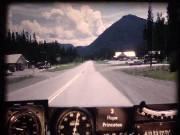
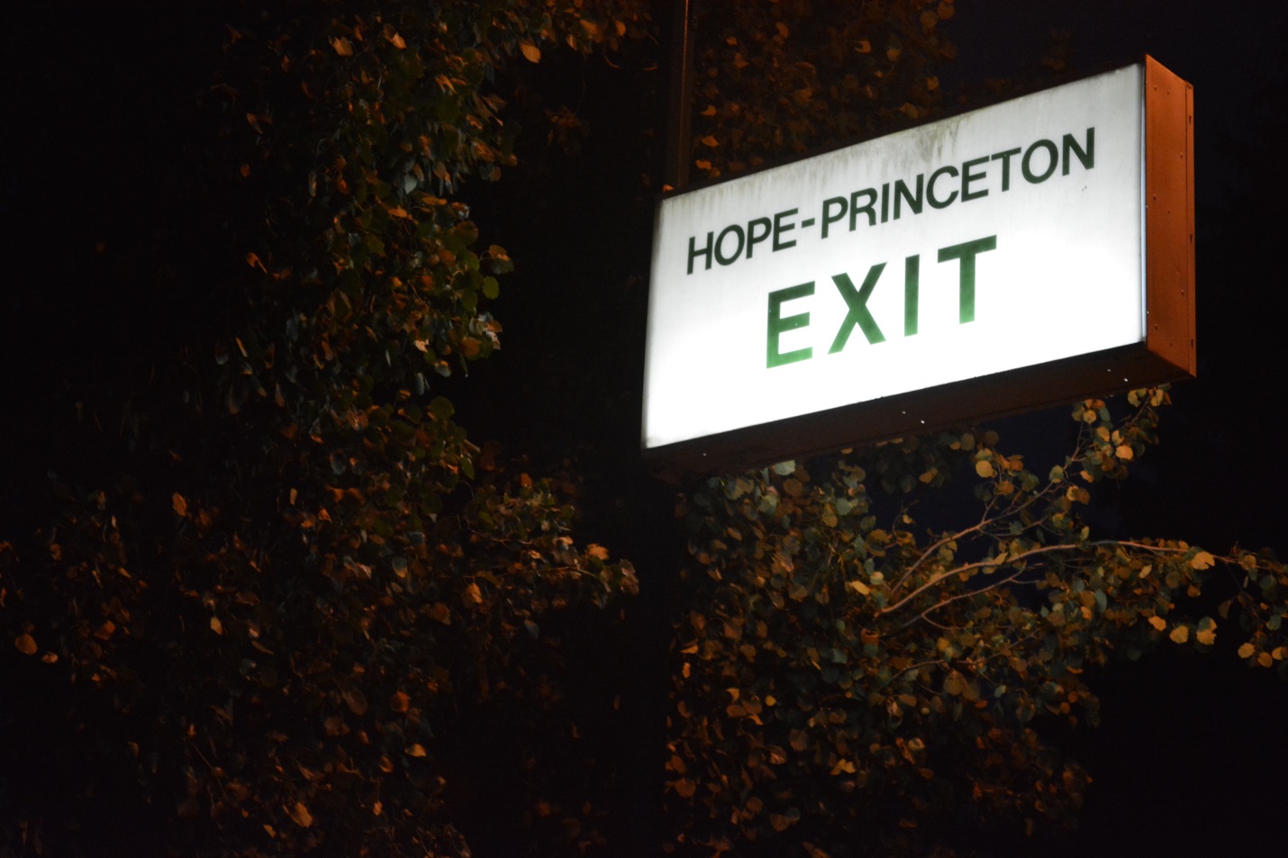
As many of you already know, we’ve been digitizing 16mm photolog footage from 1966 to give you our BC Road Trip Time Machine video series. We love this stuff and you do to. In fact, some of you have loved it so much, you’ve set out on your own road trips to document modern day roads and compare them to our time machine footage – awesome stuff. Get ready for more amazing footage with our latest installment, which takes us from Hope to Princeton on BC Highway 3, as it was in 1966.
What Makes This Footage So Special?
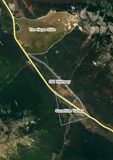
Some of you may know that, a year before this photolog footage was taken, the largest known landslide in Canadian history occurred on this stretch of highway. Devastatingly, it took four lives with it and changed the landscape of the area forever.
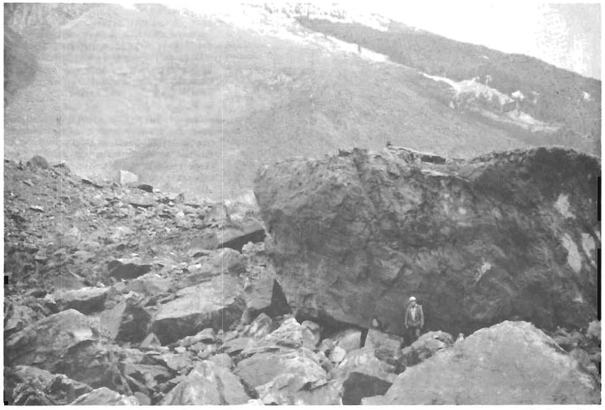
In the early morning hours of Saturday, January 9th, 1965 nearly half of Johnson Peak collapsed and descended into the Nicolum Valley, approximately 20 km east of Hope, destroying nearly four kilometres of Highway 3 (the Hope-Princeton Highway) and filling up the bottom the valley with rock and mud up to a depth of 200 feet. Outram Lake at the foot of the slide area was completely filled with debris.
Department of Highways (our old name) crews worked tirelessly for 13 days in order to re-establish the highway connection and in this photolog video you can actually see the path they cut through the debris to reconnect the road. In the early 1980’s the highway alignment was rerouted around the base of the slide debris field, instead of through it. Visitors to the area today can pull of the highway and visit a monument dedicated to the event.
In the years since the slide occurred, the Hope-Princeton Highway has seen many other changes and improvements including:
- Two lanes in each direction for the majority of the Hope to Princeton stretch
- Ongoing program of bridge replacement
- Safety lights at Skagit Bluffs
- Sunday Summit to Sunday Creek realignment and passing lanes
Before the construction of the Coquihalla (BC Highway 5) in 1986, BC Highway 3 (also known as the Southern Trans-Canada Highway) was one of two primary routes for motorists travelling from the Lower Mainland to the interior of the province and beyond. The other route was the Trans-Canada also known as BC Highway 1, which heads north out of Hope through the Fraser Canyon, toward Kamloops and then east across the province toward Alberta. Have a look at that stretch of road in 1966, here.
What are Photologs?
“Photologs” were created to capture road condition information across the province and give our engineers the ability to study a particular stretch of road without having to travel into the field. The original photologs were collected by rigging a camera onto the dash of a car that took still images every 80 feet or so and then running them all together as a single film.
Looking back on these old reels reveals a lot more than just pavement condition. The camera installed onto the dash of a car and driven over 9,000 km of BC highways captured some incredible glimpses of our province during the heyday that was the 60’s. So sit back, relax and watch this glimpse of a world long gone by in the rear view mirror.
Are you patiently waiting to see footage of a particular BC highway that we haven’t shared yet? Let us know in the comments below.
Fastest trip ever to Princeton. Enjoyed seeing Landmarks. Sumalo Lodge, Allison Pass, Towers Ranch, Similkimeen Falls, and the old Whipsaw. Spotted Miller and Brown trucks, a Chapmans and Safeways also.
Thanks for this, Jay! We love hearing what you saw. Thanks for sharing. 🙂
This is incredible! I loved it! Memories!
Glad to hear, Chris. 🙂
Do you have footage for the old Highway 1 (the “Lower Levels”, Marine Drive) through West Vancouver for the same time period? I love to take visitors through there and say at particularly terrifying/scenic spots, “logging trucks”, as I recall some scary encounters along that stretch when all traffic, including the big trucks laden with logs, had to take that route. Quite the experience for us as new arrivals from Montreal. Still one of my favourite drives and now way more scenic than scary.
The old road from Vancouver to Whistler in the 60s would be instructive, too, for those who only know the slick spacious new one. And (piling on here) the road from Whistler to Pemberton.
Hello there G Jones – thanks for your message. We haven’t seen the lower levels in our travels yet, but will add your ask to our list and share out what we find if we do find it. We do have a digitized version of the road from Horseshoe Bay to Squamish in 1966 – but not to Whistler as it wasn’t really on the map at that time and the pavement ended at Squamish. Here’s the link: https://youtu.be/JzoauPdsndM
Likewise, the road between Whistler and Pemberton won’t be in the reels as it wasn’t part of our inventory at that time. We are currently working on producing the stretch between Lillooet and Highway 97 near Cache Creek – so stay tuned for that!
Frank Slide April 29, 1903 is the largest in Canadian history.
Hello and thank you for your comment. The Frank Slide is often contested as the other significant slide event but we do believe it was smaller in scale (though more lives were lost).
Don’t know how I stumbled upon this but I was born feb 10th 1965 in Chilliwack hospital as there was a road closure and they couldn’t get home.
How long did it take to drive Vancouver to Hope in the 50’s on old Hwy 1
Hi Greg – great question. Unfortunately, we don’t have an answer for that, but we assume it would have taken longer without the TCH in place through the valley, or the Port Mann Bridge in place. Traffic would have likely gone west toward Surrey and then north across the Fraser via ferry (George Massey Tunnel opened for travel in 1959).
There was also the Pattullo Bridge which has been open since 1937.
Brings back memories . We were up there during the summer of 1966 , the heat , a/c was almost non-existent then , windows down . The good old days . Thank you .
Ahhhh, sounds divine. Thanks for sharing the memory, Larry. 🙂
Somebody mentioned the Marron Valley. We have 3 photos of the “balancing rock” near the Marron Valley Road. These are from 1945. Also have photos of the time train cars failed to load on the ferry at Penticton and ended up in the Lake. Some old photos of Penticton, former Experimental Farm at Summerland, And the old public camp ground in Penticton.
We have photos from 1945 when we travelled the entire length of what was to become the Hope-Princeton Highway. We drove through unbridged creeks, the famous forest fire, and have photos of Tashme and construction in a couple of locations. Interned Japanese were workig on the road in several locations.
Sounds like these would be amazing photos to see. We would love to see them! If you are able, please post to our Facebook page (@TranBC). Thanks!
Are you aware of tashme museum in Sunshinevalley they would love to see the photos you have
Just wondering if anybody has old pictures of the Texaco gas station Eastgate and Shell gas station at Copper Canyon
Thanks for your comment Cliff – hopefully someone can help!
Is there a photolog of Highway 3 from east of Princeton to Castlegar or anywhere towards Creston, Cranbrook & the Alberta border?
Hi Mitch – we haven’t seen one yet, but will put it on the list!
Would love to see the old highway from Nelson to Ymir and salmo. Also the new part of the Nelson to castlegar Highway. Thankyou. I definitely enjoyed seeing the old highways.
Thanks for this request Franny – we will add it to our list!
I asked when the hope Princeton was paved. Not the history of the highway. Why can’t I get an answer.
Hi Ron – we’re sorry – did you send us this request previously? We can find a record of it on this post. The Hope Princeton Highway was paved prior to its opening in 1949 and many, many times since then. Does this help?
Do you possibly have footage of Hwy 3A from Keremeos to Penticton. The portion of road I am really interested in is when they built the section of Hwy around Yellow Lake through around Trout Lake replacing the section of road through Marron Valley. I believe it was around 1949 or early ’50’s. Our road (Taggart Cres) which comes off of Hwy 3A now used to be part of the old Hwy. Curious to see where the old hwy was and when the present hwy was build. Thanks…it is an interesting piece of hwy history.
Hello Sandra,
We most likely have a photolog of 3A in the film canisters but we have not captured it yet. The furthest back these videos go is to 1966, so if you are looking for something that falls in the 1950s range (or older), I am afraid we don’t have that. You might be able to find local alignment maps in the Keremeos or Penticton museums? Hope that this helps. We are working to capture and produce these videos as we have time to do them. They do take some time to release. We have added 3A to the wish list. Hope that this helps!
My dad worked at Allison pass forever. He started when they used to actually shovel the sand out of the trucks onto the road. He retired as senior road foreman when they privatized. I worked in manning park for a year in 1980/81
Hi Brad – thanks for sharing this with us. I too worked at Manning Park for a few seasons in the 90s. Great, great memories.
It’s an amazing place and you can be proud of your history with it. Thanks again for sharing with us.
I lived at Allison Pass from 1975-1979.Didn’t like it up there but my kids did.
Do you have Hwy 499 from US border to Oak Street Bridge?
Hi Richard,
I’m not sure if we have the photolog of Highway 499 from the US border to the Oak Street Bridge.
I will forward your request to our person who is managing the photolog collection. If the footage is there, and usable, we’ll put a video together with it, and post it here on TranBC.
Hi – Do you have the route from Abbotsford to Hope? I would really enjoy seeing that stretch!!
Hello Mark,
We surely do, we just haven’t gotten to it yet. We hope to get to more of it soon and will put your request on our wish list!
This great historical footage. I know that the camera and equipment were in car top boat that was mounted on top of a station wagon. At the time it was used to check on maintenance and crews throughout the province. The reason for the short black out around half way through is a stop at the Allison Pass Camp (possibly for lunch at the bunkhouse dining room). In the mid 60s we traveled this route every summer when my father attend the army reserve camp on Vernon and saw first hand the devastation caused by the Hope Slide. I later lived and worked at Allison Pass for the ministry and contractors from 1973 to 2003
Hi John,
It’s wonderful to hear from you about the camera setup used for the photolog footage, and your time with the ministry and contractors on Allison Pass. (Sounds like the bunkhouse dining room might have been a fun stop!) You can find all our photolog videos on: https://www.youtube.com/playlist?list=PLKHNpQ_j-IWG8CG_KN7cwl5mMO2bz2x8w We add a new one every few months. You might be interested to know that all the past editions of Road Runner have been digitized and are available on: http://www.th.gov.bc.ca/publications/roadrunners/ Best Regards!
I’m currently a bridge worker for a local highway’s contractor, and have been so for 8 years, and prior to that, I worked in the roads division for 18 years. The 18 years worked, were at Allison Pass, in Manning Park. First of all, I want to say thank you, and that this video is truly amazing! So many familiar sights! Plus sites that were there in 66, but long since abandoned before I started in 89. To reply to Brian Lang’s comment, the road IS MOSTLY 4 lane, as opposed to what it used to be, and some of it will always be 2 lane. We don’t always need to drive so fast, that we don’t see the beauty of our surroundings. BTW… The company I work for, actually built the Hope-Princeton Hwy in the 40s. Thank you again for this wonderful video!
So glad you enjoyed the video, David!
Is it possible to slow the video down?
Hi KD,
Thanks for asking about the video. Yes, you can slow it down. Click on the gear shaped icon in the bottom right corner of the video screen. Click on the word “Speed” and choose your desired speed. (We find .5 to be the best speed for catching more of the details).
Hello,
In the “Time Machine” video, are those dials and scopes added for an aesthetic effect? Or would they have been present within these trips? If these scopes are real, what purpose do they serve?
Best,
Mackenzie RR
Hi Mackenzie,
The dials served a purpose! They are a spedometer, altimeter, distance marker, ball bank indicator and compass. Hope that this helps!
Neat. Are these types of survey videos still created?
Hi Mackenzie,
Road condition information is now collected using a different tool. http://tranbc.ca/2014/12/08/aran-the-flashy-road-analyzing-tool/
You wrote: “Two lanes in each direction for the majority of the Hope to Princeton stretch”
I’d love to see the statistics on that. After driving it this summer, and repeatedly getting stuck behind slow moving RV’s, I highly doubt this point. A lot more work needs to be done to 4-lane this route – all the way through to Keremos. East of there the amount of traffic dropped off significantly.