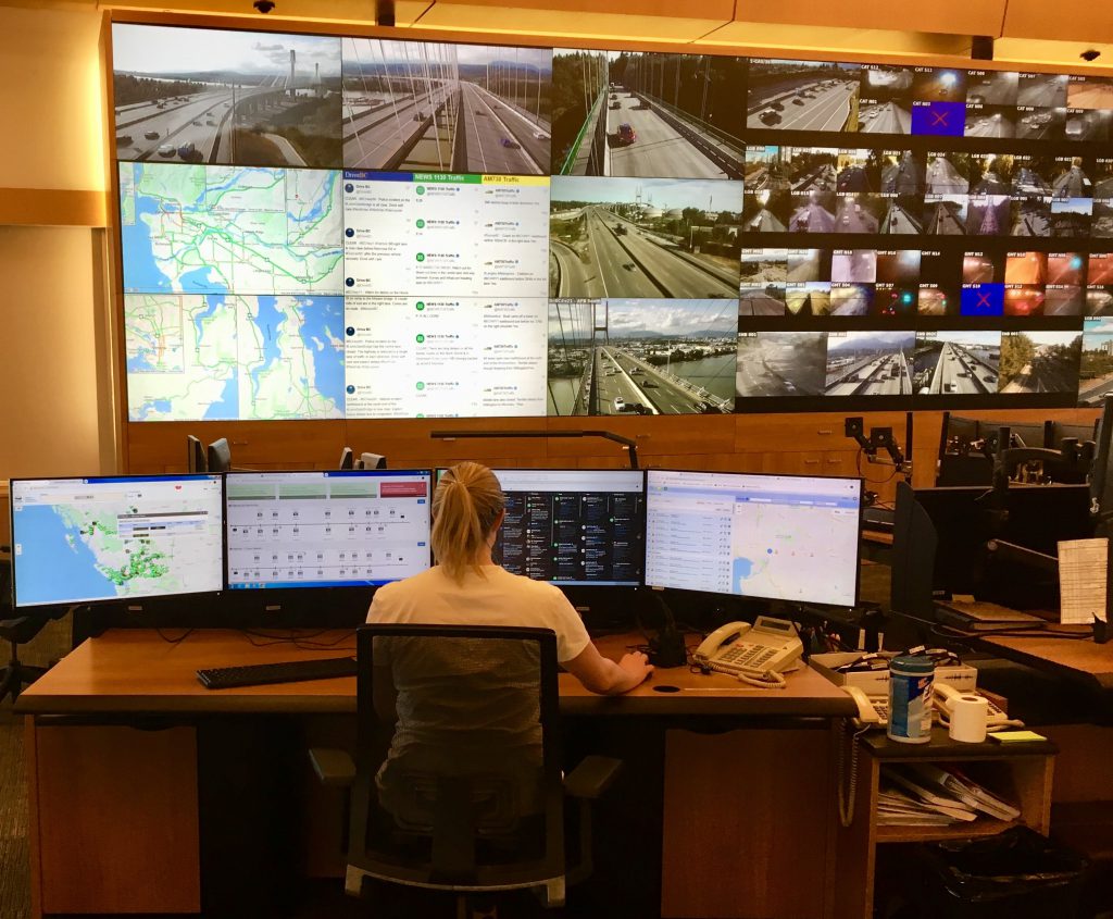
What is the Transportation Management Centre of BC (TMCBC)? Well, for starters, think of it as the nerve centre for road/weather conditions and traffic information across BC.
Based in Coquitlam, the TMCBC is the hub for collecting transportation information and communicating it to the public, 24 hours a day, seven days a week, via DriveBC and Twitter.
Your Eyes on the Road
The TMCBC is equipped with more than 200 live-streaming video feeds, and 750 cameras strategically located on highways across the province (you can see these webcams firsthand on DriveBC).
By monitoring the roads and weather so closely, TMCBC employees are able to give travellers and commercial drivers the information they need to plan a safe, efficient trip. Using information provided by ministry staff and maintenance contractors throughout the province, and numerous other sources, staff respond quickly to incidents by alerting travellers and coordinating with emergency response agencies and our maintenance contractors to manage traffic using detour routes, counter-flow lanes and overhead Dynamic Message Signs.
Some situations, like incidents (collisions, usually) are unexpected. Other events — like road maintenance, construction, parades, or community and athletic happenings — are planned. And of course, there are road conditions which could affect your travel — ice, traffic congestion, wildlife migrations, rain accumulation, blowing snow, etc.
An example of a planned event is the Highway 91/17 and Deltaport Way Upgrade Project which is expected to be complete in 2023. It’s a combination of improvements to Highway 91, Highway 17, Highway 91 Connector and Deltaport Way which will improve travel safety and efficiency. TMCBC staff post information about the work and monitor traffic and report congestion, delays, incidents and other events via DriveBC, Twitter and our dynamic message signs.
Sharing information with municipalities and other agencies is a big reason for the TMCBC’s success. Twenty-seven partnerships, including data and fibre-sharing agreements, allow us all to share video images, traffic data and fibre optic cable for the benefit of travellers.
Cutting Edge Technologies
Working alongside our maintenance contractors, the centre manages and operates lighted lane control systems for the Lions Gate Bridge, George Massey Tunnel and Cassiar Tunnel. The direction of traffic can be changed, in one or more lanes to create more efficient traffic flow, based on traffic, visibility and weather conditions.
Besides equipping staff to monitor, communicate and manage traffic flow, the TMCBC’s technology can change speed limits based on weather and other road conditions on three highways. The Variable Speed Limit Sign system sends weather and traffic data to the TMCBC, which operators use to calculate appropriate speed limit adjustments on 47 new overhead variable speed limit signs. That means posted speed limits can better reflect road conditions, as well as congestion ahead caused by traffic volume or incidents.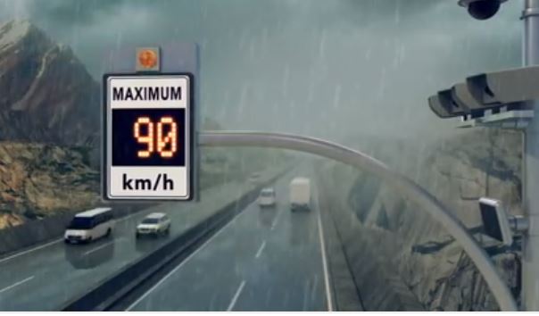
Emergency Response Headquarters
The TMCBC is a post-disaster building; in other words, it’s a building that’s essential for maintaining services when disaster strikes. If and when a major earthquake hits, the TMCBC will help lead the response as an emergency operations centre, giving emergency service providers timely information about bridges and highways.
How?
Bridges are equipped with seismic monitors tied into, what’s called, the Strong Motion Network. This data, combined with reports from the field, would inform emergency response, Emergency Management BC, supply carriers etc. on the status and safety of our infrastructure.
In fact, during Exercise Coastal Response, which ran June 7-10, 2016, in Port Alberni, the TMCBC practised its earthquake notification procedure. The centre’s tasks included coordinating key ministry operations staff, as well as supporting ministry operations in keeping track of mock incident and damage scenarios rolling out as part of the exercise.
The centre also provides support for all kinds of emergency events, for example, during wildfires and flooding. This involves both immediate response following a disaster and the recovery phase when repairs are being made, and everyday life is starting to resume for people.
The TMCBC is on the cutting edge for providing timely, relevant information for all types of travellers in BC — from daily commuters, to long haul truckers, emergency responders, vacationers, goods and services delivery people and more.
Hello,
What would be the appropriate method of communicating with DriveBC to share info about a small cycling event?
Thank-you
Hi there – please reach out to your local area office. Your event may require a permit and our staff will need more information to determine impact to traffic. Here’s a link to our regional office contact info: https://www2.gov.bc.ca/gov/content/transportation/transportation-reports-and-reference/regional-district-contacts
Hope this is helpful!
I am interested in knowing why the conditions posted recently on Drive BC for Highway #3 between Hope and Princeton are so innacurrate compared to what the actual conditions are? I have driven the highway knowing what the Drive BC postings and they couldn’t be further from the truth. Clear roads all the way with no delays or issues at all but being told to expect heavy snowfall (none forecasted), long delays (no traffic control or incidents) and extreme winter driving conditions(sunny day with clear roads). This has been a frequent occurence over the past month with many of the same traffic postings appearing regardless of the actual conditions.
Hi there Anonymous,
Thanks for connecting with us here to share your concerns. We have shared your concerns about the accuracy of the conditions reported to our staff for their review. Road condition events on DriveBC are inputted by our maintenance contractors based on the information available at the time of posting and, as you likely are aware, conditions can change on these routes quickly. Travellers on BC mountain passes should expect winter weather conditions between October and May. We hope that this is helpful. Safe travels.
Hi
wanted to under stand the ATMS platform being used and its benfits , Is it a integrated Platform to the ITS devices
Hello Nandakumar – thanks for your question. BC MoTI is using IBI Group’s ATMS platform which supports integration of a variety of ITS field devices including those critical to managing the Province’s Variable Speed Limit System, Port Mann Highway 1 Travel Time System, among others. We hope this is helpful! Safe travels.
I would like to know how your center determines when to change the new variable speed signs in the Revelstoke Area? I live in Revelstoke and travel west of town every day and there are major inconsistencies in what the new speed signs are reporting and the speeds are being changed to a reduced speed limit when conditions do not require it.
I would appreciate further communication on the matter or additional input from local residences on what is determined to be safe speeds for the area.
Thank you,
Hello David,
Thanks for your interest in the operation of the Variable Speed Limit System (VSLS). It is imperative that we receive feedback from individuals like yourself who frequently travel these corridors in all types of weather so that we are able to post reasonable speed limits that meet the expectations of as many drivers as possible.
The VSLS is currently posting speed limits based on three different inputs. Firstly, changes in the operating speed of the highway due to any type of event (construction, weather, or congestion) can reduce the posted speed limit. Secondly, the road surface condition is measured and events which are considered heavy rainfall or worse (snow and ice) may reduce the speed limit to 80 km/h. Thirdly, a reduction in visibility due to fog may also reduce the speed limit.
We are working hard to keep the variable speed limits as current as possible. As you are aware, weather changes very quickly along the corridor and we need to ensure the system is responding to those changes. We are encouraging users of the VSLS corridors to provide the ministry with feedback through the DriveBC website which we can use to continue to improve the system to provide a more reliable driving experience.
http://www.drivebc.ca/#feedback
We hope that this helps!
I see the VSLS in Eagle Pass used inadvisably during construction/maintenance. Often the speed limit will be lowered in perfect road-surface, weather, and visibility conditions, with no sign of construction … until you get a few kilometres down the road.
You can string signs upstream forever and most folk won’t lift off ’till they see some reason to do so. Those drivers are then mixed with drivers doing the reduced speed, wondering if they should because they still haven’t seen any sign, or sign of work, other than VSLS. Not good. Not making the highway safer.
Construction and temporary speed zones need to be long enough to encompass the works, and as short as possible. The VSLS sign locations are almost never in aide of this. Using them is lazy traffic management and control. It works counter to protection of the cone zone.
Yes, dropping it from 100 to 50 is likely going to require a two step drop, and yes, more signs to place and pick up. Just do it.
Thanks for your comment Grainger – we appreciate it!