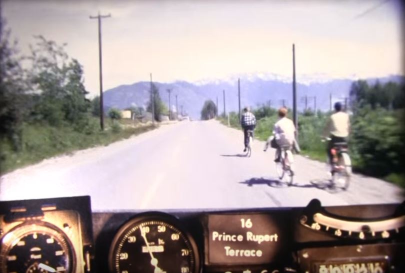
Join us on a Highway 16 road trip from 50 years ago, through some of BC’s most spectacular natural landscapes – Prince Rupert to Terrace.
The folks in our Skeena District office travelled this segment of the BC Road Trip Time Machine recently, and identified dramatic changes between then and now. What a difference five decades makes! Some comparisons to watch for on your journey…
So Curvy!
Highway 16 had a lot of curves in 1966, and vegetation grew close to its edges. Today the road is “brushed back” and has been straightened out, providing hugely improved visibility. About 85 to 90 per cent of the highway has been realigned, and those sections are now wider and have wider shoulders.
Nowadays, the road is further away from the railway tracks you see in this video. The video shows at least five level crossings where the highway crossed the train tracks. Today only one level crossing (viewable at 10:59) remains.
Many Wood Poles and Structures
All the bridges were wood back then, including several large Howe Trusses (bridges with overhead restrictions). Now they are all steel or concrete, and no wooden structures remain.
The video shows w-shaped steel highway barriers on sharp corners. Today most of the barriers are concrete, and there are more of them, to help prevent vehicles from leaving the road.
In 1966, motorists actually drove through an electrical transmission tower (see 4:26). Nowadays, you drive beside that same tower, and can see where the old route was. Back then, there were also plenty of power poles along the stretch. Only a few remain, as a large transmission line on the opposite side of the river now delivers power to Prince Rupert.
Watch for These Video Highlights
7:31 – A helicopter on the side of the road
9:27 – 35-mile mountain where now there are five avalanche control units above the highway that can be fired remotely, 24/7.
10:36 – Local landmark “Carwash Rock” before it was cut back to allow for more lane width.
You can see still photos of these and more highlights on Flickr.
Embark on this time travel experience, and at the end, you’ll be welcomed to Terrace by a big red and white banner!
To see how the road looks 50 years later, see the cool side-by-side video, created by David Zille. Prince Rupert to Terrace: Then and now aligns our video, with video from a drive that David took in 2016, slowing down for landmarks.
Our BC Road Trip Time Machine videos are produced from 16mm film footage, gathered in 1966. A camera rigged onto the dash of a car took still images every 80 feet or so, and the Highways Department (as we were known then) ran them all together as a single film. To take more nostalgic trips, see Road Trip Time Machine.
Just as i remember it but now a more pleasant drive.
Glad to hear that, Rob. Safe travels.
In 1966 the road to Prince Rupert wasn’t paved and was so narrow it was difficult for 2 vehicles to pass. Some places it curved so sharply you feared going over the side.
Brings back memories. So thankful it is no longer like this.
Thanks for your comment. We agree – a lot has changed – much for the better!
The beauty is incredible. Totally incredible. I’m from Southern California and I knew a girl from Terrace, who moved to Southern California around 48 years ago, or so. She would go back in the summer to visit her relatives, grandmother,etc. Her name was Carita. She was a beautiful person inside and out.
Thanks for sharing Bobby – yes, BC is full of beauty!
Hi everyone,
As per my comment above, on a recent trip back to Rupert (my hometown), I recorded the drive and have just posted a side by side comparison:
https://youtu.be/egOY7TMyGfk
Thanks to the BC Ministry of Transportation and Infrastructure for the original (awesome) footage!
Dave
Hi Dave,
Thanks so much for sharing the wonderful video you created, coupling our footage from 50 years ago, with what the drive looks like now and pointing out the highlights along the way. A lot sure has changed!
I’ve shared this with the folks in our Skeena District office in Terrace and they really enjoyed it. One responded, “Looks awesome!”
We’ll post it sometime soon, on our Facebook page, so that even more people can appreciate it. 🙂
Made the trip from Terrace to Pr. Rupert fro Nov. 1964 to Jan. 1966. Sure a lot of better roads now.
Hi Don,
Thanks for sharing 🙂
Amazing footage! I would like to inquire into using this content in a video piece but am having trouble finding contact info for TranBC. Could someone please contact me?
Best,
Max
Hello Max,
Thanks for your connecting with us here. Here is the official blurb about using our content:
These photographs are being made available for publication by news organizations and/or for personal use printing by the subject(s) of the photographs. The photographs may not be used in materials, advertisements, products, or promotions that in any way suggest approval or endorsement of the Province of British Columbia.
So, basically, as long as you are not using the footage for commercial gain, you are free to use it. We only ask that you please credit the BC Ministry of Transportation and Infrastructure if you do use it.
Hope this helps and if you have any other questions, don’t hesitate to let us know. We would also love to see your final video!
Made that trip many times to visit our cousins in Terrace. Dad worked for CN and did that trip as well, hanging out in the caboose. Found out after we moved away that Mom always had to be asking him questions to make sure he was awake. As the route followed the tracks quite closely, Dad could drive it almost while sleeping. Scary to think about that now. 16 to Terrace was my first highway driving as well.
Wow – great stories! Thanks for sharing with us Colin. 🙂
After many many thousands of trips starting in 1956, O what a change.
Bill Kearley
Aarin Trucking Ltd.
It was great to be part of the reconstruction.
Time to tee up a video car and do it again – 02 July 2016, exactly 50 years later. Interesting to se what has, and hasn’t, changed.
Hi James, on a recent trip back to Rupert (my hometown), I recorded the drive and have just posted a side by side comparison:
https://youtu.be/egOY7TMyGfk
Thanks to the BC Ministry of Transportation and Infrastructure for the original (awesome) footage!
Dave