A strange thing happens when you’re travelling BC’s highways and you head through Rogers Pass, drive a section of Highway 93, cruise alongside Long Beach near Tofino, or travel Highway 97, 133 kilometres north of Dawson Creek. You see, the ground under your tires changes…
You may think that’s provincially owned and operated road beneath you…but it’s not. These stretches of road are owned and operated by the federal government’s Parks Canada Agency, which has a long involvement with the surrounding areas for ecological (parks) or military (Second World War) reasons.
The road doesn’t feel or look a lot different, and there’s little to draw attention to the transition from provincial to federal highway. That’s because the two governments don’t want your travel experience to be a whole lot different. We both focus on safety for motorists and keeping travellers informed. We work behind the scenes to help you get to your destination safely, no matter which jurisdiction you move through.
Southeastern B.C.
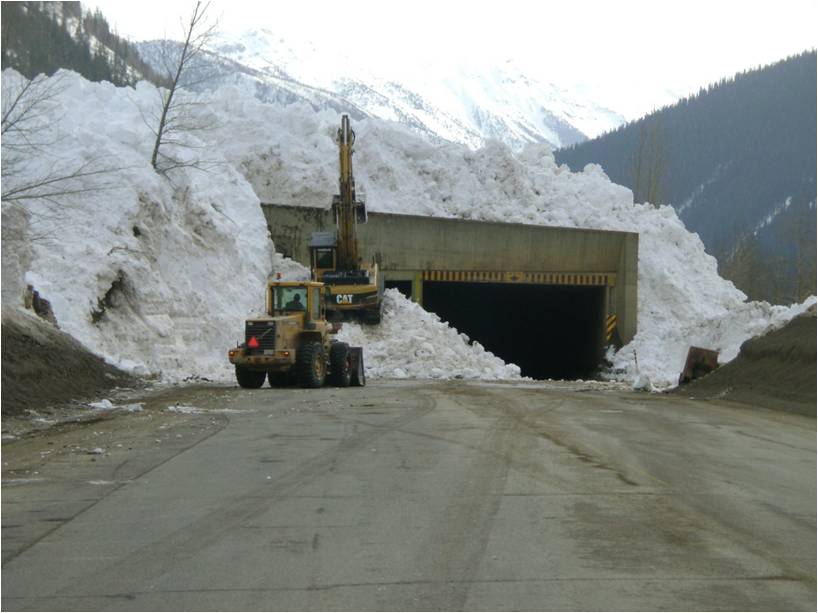
The Trans-Canada Highway in southeastern B.C. travels through federally-owned Mount Revelstoke, Glacier and Yoho national parks. More than 100 kilometres of road are maintained by Parks Canada’s Highway Service Centre. Parks Canada, in partnership with Canadian Armed Forces, operates the world’s largest artillery-based mobile avalanche control program to keep highway travellers safe from avalanche hazard in Glacier National Park. Information about road conditions in the national parks is posted on overhead highway signs at Revelstoke, the summit of Rogers Pass, Golden and near the BC- Alberta border.
Federally operated roadway also exists on Highway 93, beginning about one kilometre east of Radium Hot Springs at Kootenay National Park. This section goes northeast for 102 kilometres to where it meets with Highway 1, at Castle Junction, in Alberta.
Because DriveBC is where the public looks for current road conditions, Parks Canada provides the BC Ministry of Transportation and Infrastructure (us) with highway information for all four parks, which we post on the website.
“Our partnership with DriveBC is invaluable,” says Brenda DeMone, director of highway operations for the mountain national parks, for Parks Canada. “DriveBC provides travellers with current information on road conditions, as well as incidents, temporary delays for avalanche control and wildlife on roads, to help make everyone’s journey through our national parks safe and enjoyable.”
Should you encounter road conditions of concern while travelling through these federal areas, Parks Canada is ready to respond. For Revelstoke and Glacier National Parks, contact Parks Canada at 1-250-837-7500 and let them know where you saw the problem. For Yoho and Kootenay National Parks, call Park Canada’s Banff dispatch at 1-888-927-3367. If you’re not sure which national park you’re in, or if you’re even in one of the parks, call our contactor Emcon Services at 1-866-353-3136, to tell them of the location.
Vancouver Island
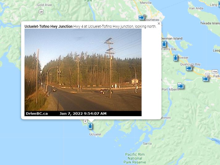
When heading for Tofino on Highway 4, through Pacific Rim National Park Reserve, you’ll again be on federal land. Two message signs, between Port Alberni and the junction by the park, alert drivers to conditions on the stretch. Should you have any concerns with highway conditions within the park reserve, call Parks Canada’s 24-hour phone line at 1-877-852-3100. If you’re not sure whether you’re in the park, make note of your location and check in with our contractor, Mainroad Mid-Island at 1-877-215-6006.
Alaska Highway
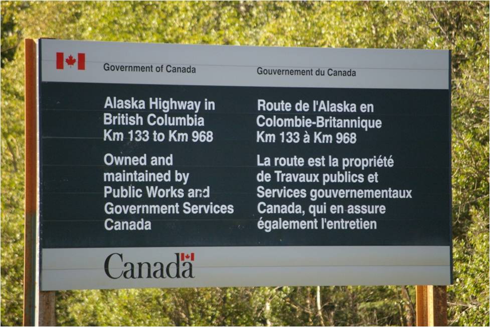
Motorists on Highway 97 will find themselves on federal highway, once they get exactly 135.57 kilometres north of Dawson Creek — a spot also known as Mile 83 of the Alaska Highway. The Alaska Highway was built through Canada to connect the US to Alaska during the Second World War, and was an epic feat when completed in 1942. During the late 1960s and 1970s, the provincial government paved from Mile 0 at Dawson Creek, to Mile 83, and eventually the remainder of the route to Delta Junction, Alaska was hard surfaced.
About two kilometres before Mile 83, the provincial government has a riverside rest area which offers running water, flush toilets and a playground. The federal government’s overhead message sign is strategically located nearby to let you know of any conditions or concerns further north. The rest area is the last place to turn around for a long way, should travellers decide the extended, steep hills of the famed 2,232-kilometre Alaska Highway are more than they want to take on.
For a short section through Fort Nelson townsite, the road becomes provincial again, then it’s back to being federal highway. Should you spot problems on the federal route, contact 250-774-6956. If you’re on provincial road, call our maintenance contractor, Dawson Road Maintenance Ltd at 1-800-842-4122.
While the ground beneath you doesn’t change in any physical way where sections of road become federal highway (and you may not even notice a difference between provincial and federal routes) it’s an interesting distinction. The provincial and federal governments work together to make sure the highways are safe and the transition between the two jurisdictions is seamless, so you can keep your eyes on the road and enjoy BC’s spectacular scenery.
Not sure who to call, when you see an issue on any of our 47,000 kilometres of provincial highway? Check to see which service area you’re in, on our Highway Maintenance Boundary Maps. Once you’ve noted the service area number, you’ll find it and the maintenance contractor’s contact information here.
hello. Just letting you know that the ‘epic feat’ link in the Alaska Highway section of this article is broken.
Thanks so much for this heads up, Rachelle. The link has now been fixed: https://www.tranbc.ca/2017/05/24/why-building-of-the-alaska-highway-is-still-an-epic-feat-decades-later/
Regard the recent washout July 1th 2022, Fireside Maintenance camp area,
on H97 under section Government of Canada .
Q; any Pro-Active Maintenance regard to remove any beaver dams will create a futur danger washout on H97….!!!
( …cheaper ill say to do this …. now it more likely a 2 years projects!!!!….)
Sincerely
Luc G.
Resident of the North Yukon Territoires Canada since 1993.
Hi Luc,
That section of the Alaska Highway is managed and maintained by the federal government. I suggest you send your comments to the company responsible for maintenance on behalf of that organization: 250-774-6956.
I drive the Alaska highway daily between fort Nelson and the Yukon my question is why did the government deactivate the northbound brake check at steamboat forcing trucks to cross the highway on a crest of the hill wich is also on a corner and many times it is almost zero visibility up there how could someone possibly think this is safe
Hi Norm,
This segment of highway is operated by Public Works and Government Services of Canada, based in Fort Nelson. I believe they have more plans for this brake check in the near future and can be reached at 250 774 6956 for details.
Hope this is helpful.
Hi,
I spent two seasons in Ft. Nelson upgrading the Liard Highway with Bob Newton crew. It is a great place to work and the people are so nice. I love the Bison roaming free there. One day I was doing my densometer work and finishing the spot I came around to get in my Highways truck. There was a Bison standing only about ten meters in front of me. The magnificent animal just walked around me just over the edge of the road and no problems. One day I would like to go back as a tourist and do the circle, up the Alaska Hwy and down the Cassiar Hwy. I worked at Iskut for two seasons where we had a project starting at the airstrip crossing the road for 17 km north. I had a trailer up there and we had an office trailer set up at the motel/restaurant around the corner from Iskut. I survived the cutbacks (3/4 of Fiels Services) and got a promotion – to Iskut 2004. My retirement project: http://uralica.com/biomass-stove.htm
Thanks for sharing Osmo! We love hearing stories from past staffers and wish you well on your current endeavours!
Hi,
I worked on Highway 77 from the junction to the NWT border. I worked at the pit inspecting the crushing, laid out stakes, calculated total volume of gravel to be crushed etc. Wild Bison just roam around everywhere. I was walking around the pit and as I walked past the crushed gravel pile I met a bison right there. Surprised me. They also surprised me on the road doing density testing. But they absolutely didn’t pose a threat as long as you didn’t bother them. I wondered what I would do and how fast I could climb that pile but the animal was no danger. It just slowly walked away.
I was there two summers. We visited the hot springs. That year there was a bear attack on someone there. Our crew rented a house in town and I really enjoyed my work and the countryside there with Bob Newton Field Services crew, around 2000 I believe.
Osmo Joronen
Engineering Assistant
Moti Field Services
Hello Osmo and thanks for sharing! We love hearing from staffers (past and present) about their MOTI journeys!
Fascinating. Who maintains the sections of Haines Road and Klondike Highways through far NW BC that access Haines and Skagway respectively? What about the Liard Highway and the Atlin Road? (I notice that there are rest areas on the official map of rest areas along these two roads, but not the other ones, nor Highway 97 beyond Mile 83.)
Hi Will. Thanks for reading. Our maintenance contractor, Lakes District Maintenance Stikine, maintains the road into Atlin through our Service Area 28 contract. South Klondike Highway and the Haines Highway are maintained by Yukon Highways. These roads originate in the Yukon, terminate in the United States and do not connect with BC highways. So, they are not considered part of BC’s highway system. Hope this info is helpful!
https://www.yukoninfo.com/highways/
I live in charlie lake bc every since dawson matanice took over it’s been the worst I have ever seen the hi way the alaska hi has no sand and no plows in sight
Hi Michelle – thanks for your feedback. We will share this with our local area staff but also encourage you to share this feedback directly with the maintenance contractor as this is the most direct way to let them know and they are required to log and respond to all incoming concerns.
Here’s their contact info: https://www.dawsonroadmaintenance.ca/service/
The USA has nice paved roads, they are always looking after their people on the road. Maintenance, maintenance. A little less alcohol for Christmas parties and use the excess cash for maintenance.
Hi Karen,
Thanks for your feedback. We make safety a priority for our roads and drivers through our road maintenance, both in winter and in summer. If you’re curious about the details, it can be found on our Highway Maintenance website here: https://www2.gov.bc.ca/gov/content/transportation/transportation-infrastructure/contracting-to-transportation/highway-bridge-maintenance/highway-maintenance
Haha if you care so much about safety on our roads then why was the northbound brake check at steamboat mountain deactivated causing slow
Moving trucks to cross the highway on a crest of a hill witch is also on a corner most times in zero visibility conditions in fall and winter months please explain how you think this is safer for all involved
Hi Anonymous,
This segment of highway is operated by Public Works and Government Services of Canada, based in Fort Nelson. We believe they have more plans for this brake check in the near future and can be reached at 250 774 6956 for details.
Hi, I was wondering if the Federal Government may consider an emergency service provider for the desolate stretch of road along Highway 97 between Fort St. John and Fort Nelson? I would like to provide details on this proposal.
Athabasca County in Alberta has a similar program where they sub contracted emergency services to a contractor along Highway 63 due to the extended travel time from the nearest first responders.
Now that Canada LNG is going ahead, there will be an increase in highway traffic again, as seen in 2013, along with the increase in motor vehicle incidents. If a person has a collision or roll over near Pink Mountain, for example, it could take over 2 hours for fire/ rescue and BC EMS to arrive.
Hello Kris,
We spoke with our local area manager who asked that you contact the Federal Government directly at the following regarding this:
George Smith,
Manager, Alaska Highway Maintenance Program – Public Services and Procurement Canada/Government of Canada
Fort Nelson, BC
Office: 250-774-6956
Email: George.Smith@pwgsc-tpsgc.gc.ca
Highway 97 sure changes with the jurisdictions. Traffic Light after traffic light for hundreds of kilometers. When I drive from here in Vernon to Osoyoos it’s over 3 traffic lights every km for 180km. As soon as I cross the border, the highway is straighter and wider with less build-up right to the highway. Plus, I can drive on average 15km/h faster.
When I take 97 north, it’s lots of traffic lights again and lots of sharp corners. Then I get past Fort St. John, and it’s smooth sailing except for the provincial part around Fort Nelson and the windy parts over the Rockies, but those are being straightened by the feds, so it’s a far better road than the 97 from Prince George to Dawson Creek!
Hello Thomas and thank you for your question. BC sure is becoming a busy place, isn’t it? As communities grow and evolve around highways ( as we see happening along Highway 97 in the Okanagan), traffic volume levels require traffic lights to allow those communities access to major highways. When traffic volumes increase exponentially and as budget allows we try to install overpasses to accommodate.
But the road DOES change. The potholes and damaged sections of the road through the Park on Hiway 4 are causing accidents, damages and hundreds of dollars in repair bills. It is absolutely ridiculous that we have to travel that road daily in that condition!
Should you have any concerns with any part of Highway 4, please contact Emcon Services at 1-866-353-3136. The contractor provides maintenance for both the federal and provincial governments.