It was the most ambitious highway project in the province’s history.
It’s one of the most heavily travelled route in all of British Columbia.
From top to bottom, motorists can experience every single type of weather condition known to man. With a summit reaching 1,244 metres tall (imagine almost 3 CN Towers stacked up), it isn’t uncommon for it to be snowing at the peak and sunny at the base.
We’re talking, of course about the Coquihalla Highway.
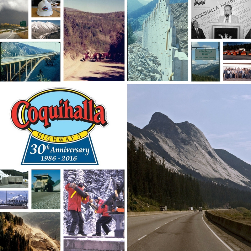
The Coquihalla turns 30 (!) this year and to celebrate, we’ve collected images, videos and stories recounting the amazing tale of its construction and the impact this famous route has had on our lives.
Situated in southwestern BC, the Coquihalla (part of BC Highway 5) was completed in three phases. The first phase of construction, which officially opened on May 16, 1986, was the longest stretch at 120 kilometres. With the second and third phases, which linked Merritt to Kamloops and to Peachland respectively, overall travel time was significantly reduced, opening up a connection between major coastal communities and the interior of BC and providing a faster, safer alternative to the Trans-Canada Fraser Canyon route.
History: Choosing the Route and Making Inroads
Design of the Coquihalla Highway began with exploration of the proposed route in 1973, followed by an official survey in 1978 when the first construction contract was let.
Accelerated design and construction began in the spring of 1984 in preparation for Expo 86 in Vancouver. To be sure the project was completed on time, more than 10,000 people were needed to fill all of the jobs. More than 1,000 pieces of heavy equipment worked non-stop every day during the summer of 1985 to get it done!
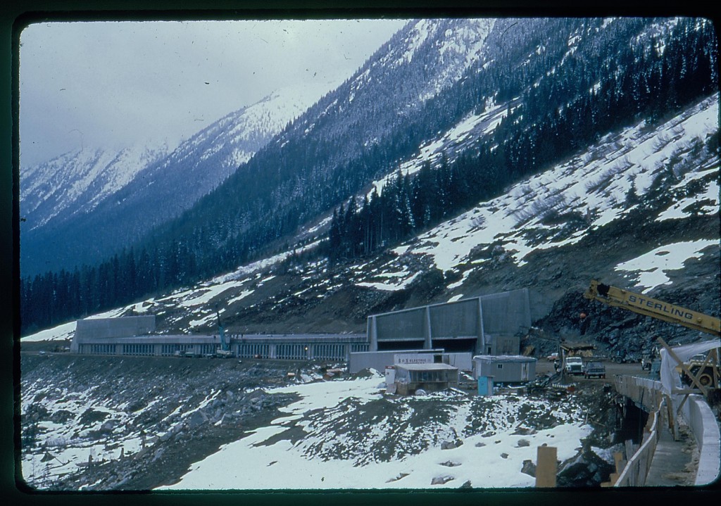
The flat floor of the Boston Bar Creek valley was identified as a better route than following the Coquihalla River’s steep and narrow upper gorge; however this route also meant an increased risk from avalanches that had to be overcome. An incredible eight avalanche dams, 19 containment basins, two diversion trenches and three sets of avalanche benches were built in addition to the massive Great Bear Snowshed, to protect the highway.
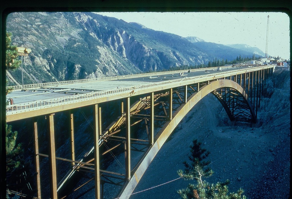
The Coquihalla Highway is also bridge engineer’s dream, with a bridge or overpass on average every 3,158 metres.
In total:
- 18 highway interchanges
- 38 bridge and overpass structures
- 19 vehicle underpasses and
- 50 pipeline crossings were built along the route
Green Ahead of its Time
The construction of the Coquihalla also included award-winning work to protect fauna and flora along the route. All environmental work was planned and performed under the supervision of environment and fishery experts.
Connecting Communities, Building the Future of BC
When the Coquihalla opened, it wasn’t just a faster route to the interior of the province; it also became a vital link between the community of Merritt and the rest of the province. For years leading up to the opening of the Coq, the community of Merritt had been lobbying the province to build a new route through the Coquihalla Pass to Hope, which was accessible only by cattle trails. Today Merritt is a vibrant and growing community, an important hub between the coast and the interior of the province. The City of Kamloops and the Okanagan have also experienced a tremendous amount of growth and change since the Phase 2 and 3 of the Coquihalla were completed, evolving into the bustling metropolitan hubs we know them as today.
The Coquihalla corridor also plays a vital role in our Pacific Gateway strategy by supporting the fast and efficient movement of goods between BC, the rest of Canada and the rest of the world.
Coquihalla, Phase 1 by the Numbers
- Nine million tonnes of gravel (625,000 dump truck loads) were hauled.
- 45 kilometres of culvert pipe were installed.
- 700,000 loads of dirt were hauled.
- 160,000 tonnes of concrete were poured.
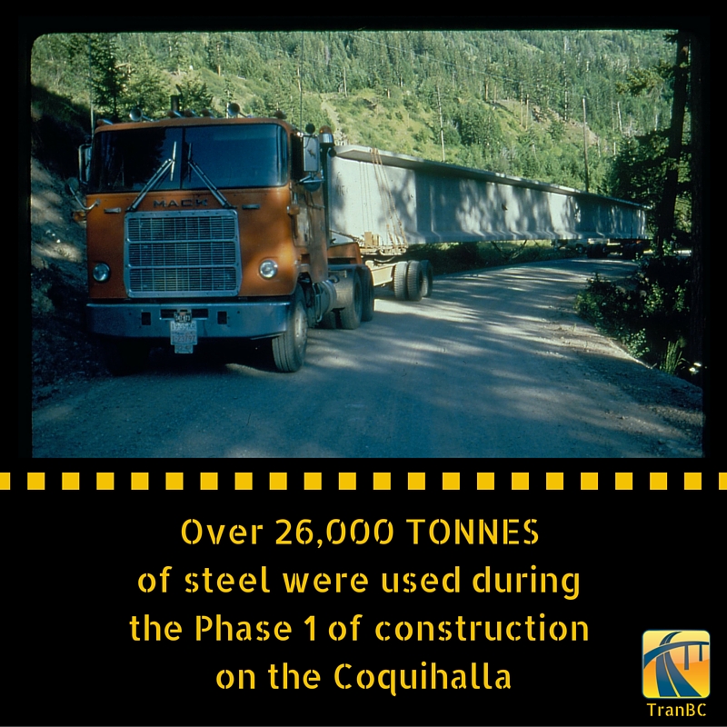
- 26,000 tonnes of steel were installed.
- 90,000 metres of fencing were installed.
- 150,000 metres of median and guard rail were installed.
Stay tuned as we shared more stories, images and videos celebrating the Coquihalla. If you have a question or comment about this or any of the other work we do, let us know in the comments below.
Hi – Can you say why the Coquihalla was not designated to be the Trans-Canada Highway, transferring that designation over from Hwy. 1, which follows the Fraser River up to Lytton and Cache Creek? In other provinces, the Trans-Canada was moved to wider, better, and safer highways as they were built, most notably as city bypasses. Why did this not happen for the Coquihalla?
Hello, Mark – thanks for your question. Unfortunately, the answer to that decision is not very clear – we no longer have staff on hand these days to provide that level of insight as most have retired. The Coquihalla was delivered as a provincially funded project, not federal – which might have been why it was not transferred over to formal TCH designation. Hope this is helpful. Safe travels.
who owned the cattle range the coquihalla was built on, I have heard Bill Bennett owned much of the land
Hi there Judi – thanks for connecting with us here. Before the construction of the Coquihalla, there was a cattle trail between Merritt and the south coast. There are also most certainly are also cattle ranches in the Merritt area – it is an area rich in cattle culture.
Here’s a link to a few historical images and documents which might interest you.
https://www.flickr.com/photos/tranbc/26874262251
https://www.flickr.com/photos/tranbc/26336800174/in/album-72157668240995405/
https://www.flickr.com/photos/tranbc/albums/72157668272082045
https://www.flickr.com/photos/tranbc/albums/72157668240995405
https://www.flickr.com/photos/tranbc/albums/72157667588133180
We hope this is helpful.
How long did it take to build the whole highway?
Hello Nancy – thanks for your question. On May 16, 1986, Phase 1 was officially opened and Highway 5 was re-routed between Hope and Merritt. Phase 2 between Merritt and Kamloops opened in September 1987, re-routing Highway 5, while Phase 3 was opened in October 1990 and designated as Highway 97C. Hope this information is helpful.
My father was the superintendent on the last bridge before Merritt. 34 years ago on August 22, 1987 just after the highway opened I got engaged on Halloween night on the bridge. As an extra bonus was nicely surprised to enter Merritt with Halloween fireworks.
What a wonderful memory! Thank you so much for sharing that with us here, Theresa! <3
Where does the coquihalla begin from the east to the west and end from the east to the west
Hi Trudy – great question!
Here’s a link to more information on start and end points of BC highways. We hope you find it helpful: https://www2.gov.bc.ca/gov/content/transportation/transportation-reports-and-reference/reference-information/numbered-routes#N5
Such a cool article & awesome video! It’s hard to comprehend the speed and scale of this project, it really beggars belief. The archival footage is fascinating. I wasn’t born yet when the Coquihalla was built; until now, I never realized that it was constructed in less than two years!
I have very fond memories as a child riding through the Great Bear Snow Shed on family vacations en route to Revelstoke, it was so exciting, especially knowing there were more ahead! Riding through the mountains and seeing the landscape at that age really inspired my passion for nature & wilderness.
To this day, I love driving the Coquihalla, particularly the area by the summit. The view of Yak Peak with its granite face is just amazing, whenever I drive through those mountains I feel as though one is entering a different world.
Once again, thanks for posting this great article & reminding of fantastic memories!
Hi Jeffrey and thank you for this wonderful comment and kudos. We love hearing these stories, about the impact BC highways have on those who travel them. Safe travels.
I just found my I drove the Coquihalla on opening day sticker from when I was 14 and drove it with my parents. It’s still in great shape LOL
Score! That’s a prized possession these days. Most of those bumper stickers were stuck on bumpers back in the day. Thanks for sharing with us, Mark. Safe travels!
Great work out there, through these troubling times. (May 6th, 2020)
HAPPY BIRTHDAY
In the rain and weather… You know the STORY. WEATHER and ALL it’s GLORY, so my hats off to all who are part of the story.
Thanks Bart and Moe show! We appreciate you taking the time to send us a message. Safe travels out there!
my grandfather james edward steven was the head in engernering the tunals i did not notice his name in this artical
did i miss it or is it not in here
ps. sorry about the spelling
Hi Matthew,
Thanks for your message. Unfortunately, we were only able to highlight a few of the people who contributed to this project – a complete list would be hard to compile at this point. We sure do appreciate the pride you and your family must have in knowing the work your grandfather did!
I understand that the caribou have migratory routes that traverse the area where the Coquihalla was built and that tunnels were built specifically for animal migration. Is that true and do you have any documentation resources about how environment and biodiversity preservation were considered? Any people who remember these considerations?
Thanks
Hello Laurence,
The Coquihalla project was groundbreaking in many ways and environmental work was one of those areas. This video explains how wildlife fencing and underpasses were constructed as a part of the project to help moose and deer move freely without having to engage with traffic.
https://youtu.be/JQkqrsWJOqw?list=PLKHNpQ_j-IWG0KGtZyzQt3kB9hZsGu9kQ
We don’t have too many folks left from the days of the construction, but we have forwarded your question to our Environmental Management group, who are responsible for managing the safety of wildlife along BC highways.
Myself, Ross Coulter and Bill Kobenter worked in the Design & Surveys Department. We researched and maintained the geometric design standards that all engineers and civil technicians used for the production and design of this magnificent feat of engineering. I’ve worked on the 144″ water pipeline in Libya, Bay Area Rapid Transit extension and the China Town extension for San Francisco Muni and none of then presented the technical difficulties that the Coquahalla did. Kudos to all my coworkers for doing the impossible.
Thanks for sharing this with us Paul – we love hearing these stories from the men and women who played such an important role in helping build our province!
Thank you Paul! I am Bill Kobenter’s son. My father was a very dedicated member of Highways going back to the WAC era. He always prided himself in working with a dedicated team of knowledgeable and skilled co-workers. He, like many, believed passionately in the domain, the discipline and the work. Reading your comments brought back a smile and many memories, such as the time there was a competition to design a new logo for Highways and my fathers contribution (which years later looked similar to the ICBC logo!). Once again thank you!
my grandfather james edward steven was in that dapartment did you meet him
he pasted last year and i didn,t get to know him much before he pasted and i am doing a family tree project and i some info.
pls contact me at Loonlake11@gmail.com if you have any intell on him, thanks.
Thanks you so much for the page you have put together. My uncle, that has since passed away, was one of the superintendent of the jobs and I remember seeing a old 8 mm video of him flying over the route in a helicopter. And pictures he took as the project went on as he loved his camera. I was lucky enough to even been able to travel the highway before it was open and remember how strange it was with know other cars around.
Randy Jackson
Wow Randy – how cool is that?! Thanks for sharing your story with us – we love hearing personal highway history like this. 🙂
I agree the toll booths should have remained open to cover maintainace costs .i am curious to know how long it took for construction of the connector hwy 97 c . It opened well after the coquihalla , but when did construction begin ?
Hello Maggie,
Construction of the connector began shortly after the opening of the Coquihalla Phase 2 in 1987 and was completed in 1990. You might enjoy browsing some of the old newspaper clippings about this here: https://www.flickr.com/photos/tranbc/collections/72157668147973266/
Just worked out that if the Coquihalla had been built at the same rate as the Trans-Canada is being 4 laned (less than 4 km per annum since 2001) the FIRST phase would have opened in 2008.
Hi Nick,
Thanks for this stat.
In the Alps, a vast region that has been travelled for many centuries, all roads, including the latest freeways, avoid high plateau regions. These roads are designed to follow valleys, even if it means digging expensive tunnels in narrow valleys and under passes. For two excellent reasons: to avoid high altitude weather and to stay close to services. Valleys are lived in, so service stations and emergency services are never far away. That has a spin-off effect as well (hotels, restaurants, motor services) in regions that need a steady influx of money for long term sustainability.
These factors were disregarded when the Coquihalla and the 97 connectors were built.
Hi Bruno,
Thanks for connecting with us here. The majority of BC’s highways follow valley routes for the same reasons you mentioned above. The Coquihalla was constructed to save travel time by providing a more direct route to the interior of the province. Its midway point (Merritt BC) has a variety of commercial and emergency services as well. That being said, BC Highway 1 and 3 are still available for travellers who wish to take the lower, slower route. Hope that this helps!
I took the Coquihalla highway after it opened on my way to Expo 86. I got one of the bumper stickers. “I Drove the Coquihalla”, which I still have. Good article, some interesting facts.
Thanks for your feedback Bryan and remember to keep that bumper sticker – they’re a collectible now!
I am curious about the statement that it’s the most heavily travelled route in BC. According to your figures the Malahat has a higher daily volume but if that doesn’t count because it’s on the Island, then surely Highway 1 through Coquitlam Burnaby and Vancouver sees more traffic?
Hi Brendan,
Thanks for connecting with us and for the great catch. This should read “one of the most heavily travelled routes”.
Who were the contractors on the coquihalla
Hi Cawston,
Are you looking for the names of specific contractors used during construction?
I think it was a mistake to remove the toll booths, since the revenue $100 million or more per year, could be used to improve other routes -as mentioned by other commenters. Also since it seems half the traffic is from Alberta, it was a method by which they could contribute to both the construction and ongoing improvement and maintenance costs.
One sorely needed improvement is an eastbound off-ramp onto 97C near Merritt. Traffic now has to slow right down for a 180 turn, and often as not stop at traffic lights leading to visitor centre! Then turn left and grind up a major grade. Inconvenient for passenger cars but a huge time and fuel waster for transport trucks. With a proper off ramp much of the vehicle momentum would be preserved for the uphill grade.
Hi Keith,
Thanks for your comments. We have shared them forward with the local area manager for review.
A highway to be proud of. Can’t say the same for sfpr hwy17 or hwy7 or hwy97 or pretty much every other highway in bc besides highway 1 through the lower Fraser
Hi Jose,
Anything we can help with?
Incredible, thanks for sharing
Thanks Mae! Be sure to check out our main page for more: http://tranbc.ca/coquihalla-30th-anniversary/#sthash.7tGJsokJ.U2Jdczgd.dpbs
Shame the traffic to the rest of Canada then has to negotiate a 55 year old, 2 lane, winding accident and closure prone bottleneck. Despite the ‘aim’ to 4 lane from Kamloops to the Alberta Border and Christy Clark’s promise of $650 m over 10 years, at the current rate of progress they will still be doing so in 30 years from now (and for some considerable time after that).
Hi Nick,
Thanks for your comment. We are sorry to hear you are not happy with the rate of progress to four lane the Trans-Canada from Kamloops to the Alberta border. As you know the geography along this route can be restrictive but we continue to make improvements as outlined on our Trans-Canada four-laning program website here: http://engage.gov.bc.ca/bchwy1/projects/
Biggest engineering mistake ever made!!! Disgusting tragedy!!!
Sorry to hear you feel that way, Sue.