British Columbia is located within the Pacific Ring of Fire, which is an area around the Pacific Ocean that experiences a high number of earthquakes. As much as we’d like to, the Ministry of Transportation and Infrastructure can’t stop a major earthquake from happening, but we can prepare to reduce its impact on motorists by arming our structures with early warning sensors.
 Have you ever heard of a primary wave? No, it’s not coveted by surfers in Tofino. The primary wave, or P-wave, is of the seismic variety, and warns of the gnarly incoming force of an earthquake. We monitor P-waves to help protect travellers against earthquake damage to some highway structures.
Take the George Massey Tunnel, for example. Early warning sensors are located at both ends of the tunnel because an earthquake could possibly damage this underwater link between Richmond and Delta. The early warning sensors are designed to “catch” the P-wave, which triggers roadside warning signs alerting motorists not to enter the tunnel before the earthquake, or secondary wave (S-wave), hits.
For all you visual learners, this animated graphic helps explain the movements and speeds of the P-wave and S-wave.
The P-wave travels nearly twice as fast as the S-wave. Now, imagine driving along Highway 99, approaching the George Massey Tunnel from either Richmond or Delta. Here’s what you would experience if an earthquake occurred off the coast.
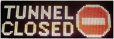
- You would see an LED message sign reading “TUNNEL CLOSED” and displaying a “do not enter” symbol, same as you would if there was an incident. There are three signs located at each end of the tunnel;
- The red X “closed” signs overhead all lanes entering the tunnel are activated, as are the green “open” signs on all lanes exiting the tunnel. The goal is to get everyone out of the tunnel as quickly as possible while preventing cars from entering;
- From the time the warning signs are activated, drivers have between five and 20 seconds before the S-wave arrives, possibly causing damage to the tunnel.
In a disaster situation, every second counts toward saving lives. The ministry’s goal is to improve and expand the province’s early warning system, something we’ve been doing in partnership with researchers from the University of British Columbia.
 Complementing the early warning system is the online British Columbia Smart Infrastructure Monitoring System‘s (BCSIMS) network of strong motion sensors (note: you may need to download Microsoft Silverlight to fully experience the site). There are more than 100 of these compact sensors strategically placed around Vancouver Island and the Lower Mainland – everywhere from schools and local businesses, to private residences and the bridges themselves.
Although you may not realize it, minor earthquakes occur quite regularly. Motion sensors help us understand how the earth below our feet is shifting by measuring and transmitting data about local earthquake activity to ministry inspectors, emergency teams and the public. An online map shows ongoing visuals for seismic events, making the network a particularly helpful tool for Emergency Management BC and responders needing to identify an earthquake’s location, strength and damage.
Whether we’re monitoring ongoing earthquake activity or expanding our early warning system, being prepared for the unexpected is an important part of building transportation infrastructure in BC. Catching a P-wave early could save lives.
Congratulations on your expansion of the province’s early warning system and for partnering with researchers and engineers from the University of British Columbia. This is a much needed system to detect crustal earthquakes, along with the undersea network of sensors being implemented by Ocean Networks Canada _Neptune in the Cascadia Subduction Zone. Thank you.
Hello Jackie,
Thanks for your kind comments and for connecting with us here.
Always appreciate what you folks do for us. Thanks.