The results of the province-wide Rural Highway Safety and Speed Review are here. We went out on the road to speak with you in person and online from Nov. 29, 2013 to Jan. 24, 2014 to assess four key areas of road safety on rural highways:
- slow moving vehicles
- wildlife safety
- requirements for winter tires
- setting appropriate speed limits
At the same time, we conducted technical work, including research from other jurisdictions, and an engineering assessment of the speed, safety, design and land use for all the individual highway segments identified for speed increases. Your input and the information we gained through that technical review helped to identify and prioritize these improvements.
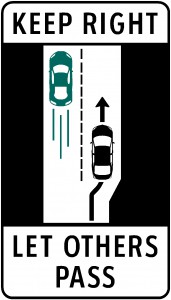 Keep Right Except to Pass
Frustrated by the safety hazards caused by slower-moving vehicles? You let us know. The ministry will be bringing forward changes to the Motor Vehicle Act to clarify the requirement for slower vehicles to keep right, while giving police clearer direction on how to enforce the requirement. We’ll also be increasing driver education about the importance of keeping to the right except to pass, and adopting new signage and pavement markings to increase voluntary compliance.
Public consultation found that people were generally divided across all regions on the degree that slower-moving vehicles were a safety concern. The exception was Highway 4 from Parksville to Tofino, for which 70% of respondents thought it was an issue. In light of this, we’re going to pilot “Slow Traffic Delaying 5 Vehicles Must Use Pullout on Hwy 4” signage in that area.
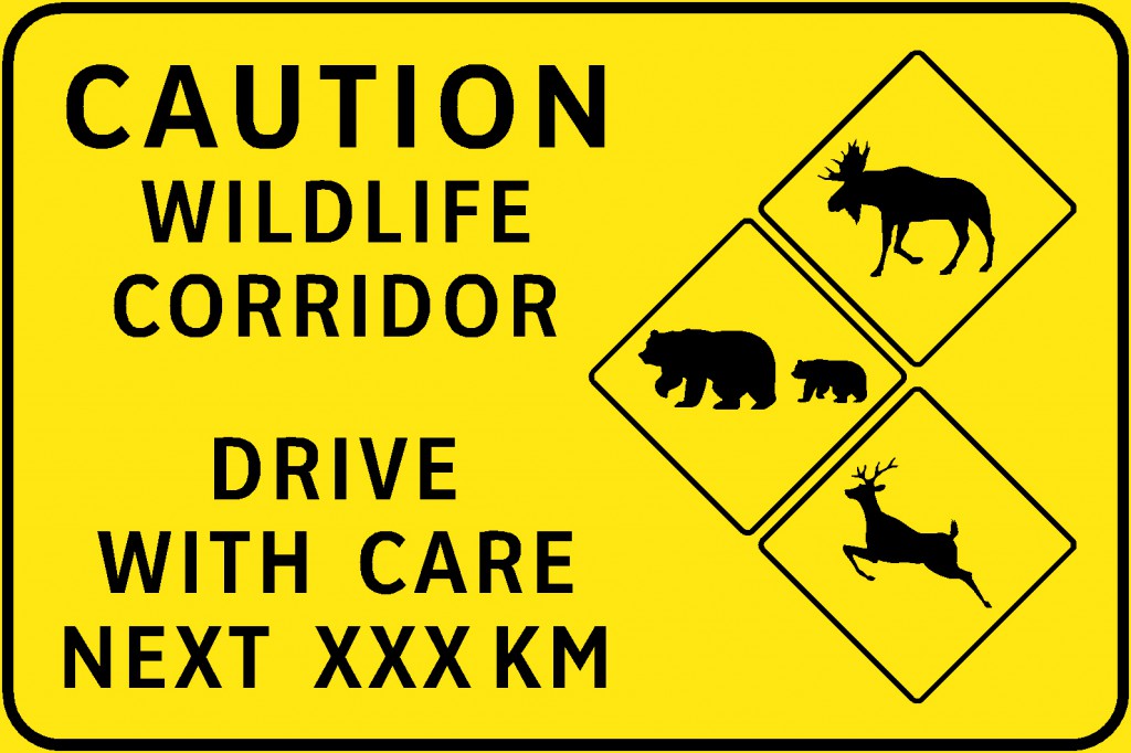
Wildlife Safety
What you told us was that you didn’t often find wildlife to be a concern in the south coast and southern interior areas of BC, while those in the central and northern parts of the province felt more likely to find wildlife to be a safety concern. As well, our data indicates that collisions involving wildlife are prevalent and identifies a number of higher risk areas.
Here’s what we’re going to do:
- Install gateway signs at the entrance to highway corridors with higher instances of wildlife collisions.
- Increase the use of flashing LED warning signs and wildlife fencing in high crash locations.
- Pilot project: two wildlife detection systems in a known high wildlife accident area on Highway 3 between Cranbrook and Sparwood. This section has some of the highest deer and elk mortality rates in the province.
- We will also continue to monitor wildlife incidents, identify high-risk sections, and implement further measures as needed.
Winter Tires Requirements
After our assessment and hearing from you, we’re going to update legislation to clarify that winter tires includes those rated Mud and Snow (M+S) and those with the mountain/snowflake symbol. Studded tire and chain regulations will also be updated to reflect new technology.
To really reinforce this, we’re installing new winter tire signs to clarify the requirements for winter tires and chains and the time-frame for use (was October 1 to April 30). We will also work with our road safety partners to put additional resources into the “Shift Into Winter” campaign, which reminds motorists to prepare their vehicles, consult DriveBC, and drive to road conditions.

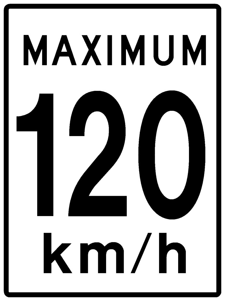
Setting Appropriate Speed Limits
Speed limits will be adjusted on approximately 1,300 kilometres, or about 15% of the total highway reviewed (9,100 km) during this process. Most of the recommended increases are limited to an additional 10 km/h with the province’s new maximum speed limit on certain sections of divided multi-lane highway raised to 120 km/h.
The majority of participants in the southern part of the province support increasing speed limits.
- 56% in central BC
- 72% in the Okanagan
- 61% in the southern interior
- For the Coquihalla/Trans-Canada Highway corridor, 70% supported a speed increase
- 81% in the Lower Mainland
- 55% on Vancouver Island
Participants in the northern region were more divided on speed limits.
- 52% of participants indicated they would prefer no change to speed limits.
- 42% of participants indicated that speed limits should increase.
Fueled by these results, decisions on each specific section of highway were also based on an engineering study which included an assessment of the ambient speed, highway safety, road design, and land use to make the final decision.
Here’s what we’re going to do:
- Speed limit changes to approximately 1,300 kilometres of provincial highway (35 sections) in the BC southern interior, Lower Mainland and Vancouver Island.
- No changes to speed limits on rural provincial highways in northern British Columbia.
- Pilot variable speed zones on sections of the Trans-Canada, Coquihalla, and Sea-to-Sky highways.
The ministry and its safety partners will monitor the speed and safety performance of the sections of highway where changes are being made to ensure the numbers of serious crashes continue to decline.
Unless otherwise noted, new speed limits will be phased in over the summer.
|
BC Highway |
Area |
Current Speed Limit |
New Speed Limit |
|
Fraser Valley and Fraser Canyon |
|||
| Highway 1 | Whatcom Rd to Highway #3 Junction | 100 | 110 (starts July 2,2014) |
| Highway 1 | East of Lake of the Wood Rest Area to Boston Bar | 80,90 | 100 |
| Highway 1 | Boston Bar to Falls Creek | 90 | 100 |
| Highway 7 | Vehicle Pull-out west of Haigh Scale, Agassiz to Highway #1 Junction, Hope | 90,100 | 100 |
|
Sea to Sky |
|||
| Highway 99 | Eagle Ridge Interchange, Horseshoe Bay to south of the Stawamus River Bridge near Squamish | 80 | 90 |
| Highway 99 | North of Depot Rd, Squamish to Function Junction, Whistler | 80, 90 | 100 |
| Highway 99 | South of Whistler Heliport Rd to Pemberton Boundary | 80 | 90 |
| Highway 99 | East of Lillooet near the Pavilion Lime Plant to the Highway #97 | 90 | 100 |
|
Vancouver Island |
|||
| Highway 1 | Three 80km/h sections between Bench Rd, Cowichan Bay and Beck Rd, north of the Nanaimo Airport | 80, 90 | 90 |
| Highway 19 | Parksville to south of Willis Rd, Campbell River | 110 | 120 |
| Highway 19 | Duncan Bay Rd to Menzies Rd, Campbell River | 80 | 90 |
| Highway 19 | Campbell River to Sullivan Rd, Sayward | 90 | 100 |
| Highway 19 | North of Campbell Way, Port Mcnellis to Douglas Street, Port Hardy | 80, 90 | 100 |
|
Southern Interior |
|||
| Highway 1 | Six Mile Rest Area near Tobiano to Savona | 90 | 100 |
| Highway 1 | Chase to Hilltop Rd, East of Sorrento (excluding 60km/h section through Sorrento) | 90 | 100 |
| Highway 1 | Canoe to Highway 23 South, Revelstoke (excluding 60km/h section through Sicamous) | 90, 100 | 100 |
| Highway 1 | Highway 23 North, Revelstoke to Anderson Rd, Golden (excluding parks) | 90 | 100 |
| Highway 3 | Start of Highway 3 to Highway 5 Coquihalla junction | 100 | 110 |
| Highway 3 | Sunshine Valley to Manning Park East Boundary | 80, 90 | 100 |
| Highway 3 | Sunday Summit to Whipsaw Creek, west of Princeton | 80 | 90 |
| Highway 5 | Hope (Exit 177) to Othello Rd | 100 | 110 (starts July 2,2014) |
| Highway 5 | Othello Rd, near Hope to Highway 1 junction | 110 | 120 (starts July 2,2014) |
| Highway 5 | Heffley to Little Fort (excluding 60km/h section through Barriere) | 90 | 100 |
| Highway 5A | Old Hedley Rd, north of Princeton to Highway 97C junction (excluding 70km/h section through Aspen Grove) | 80 | 90 |
| Highway 6 | New Denver to Purdy Rd, north of Hills (excluding 70km/h section through Hills) | 80 | 90 |
| Highway 6 | Purdy Road, Hills to Upper Brouse Road, Nakusp | 90 | 100 |
| Highway 33 | South of Gallagher Road to McCulloch Road | 90 | 100 |
| Highway 33 | North of Highway 3 junction, Rock Creek to Westbridge | 90 | 100 |
| Highway 97 | North of Willow Drive, 70 Mile House to BCR Overpass, 100 Mile House | 100 | 110 |
| Highway 97 | Gatzke Rd, north of Oyama to College Way, south of Vernon | 90 | 100 – Pending completion of engineering assessment to determine if median barriers are required before implementation of the new speed limit |
| Highway 97 | Highway 97A junction near Swan Lake to Westside Rd | 80 | 90 |
| Highway 97A | North of Smith Drive, Armstrong to Highway 97B junction, Enderby (excluding 50 km/h section through Enderby) | 90 | 100 |
| Highway 97A | Highway 97B junction, near Grindrod to Sicamous (excluding 50 km/h section through Grindrod) | 80 | 90 |
| Highway 97C | Merritt to Aspen Grove | 100 | 110 |
| Highway 97C | Aspen Grove to Drought Hill Interchange, Peachland | 110 | 120 (starts July 2,2014) |
Remember, speed limits are the maximum speed for ideal conditions so reduce speed in rough weather or poor road conditions. Checking DriveBC before leaving home is a good idea, too.
Your safety remains the ministry’s number one priority. We will continue to closely monitor safety on all provincial highways, and are committed to the ongoing evaluation and monitoring of speed limits and safety measures. We’ll be working closely with the road safety community through the Road Safety Executive Steering Committee.
This committee includes the ministry as well as health professionals such as the Provincial Health Officer and the Chief Coroner, the RCMP and local law enforcement, ICBC, WorkSafeBC, and RoadSafetyBC. The ministry will also work to improve the way that data critical to identifying trends in highway safety is shared among all committee members.
The number of serious crashes on provincial highways has decreased by 28 per cent since 2003. This is the direct result of targeted and strategic enforcement, driver education, improved vehicle technology, and increased penalties.
Join the discussion